Buzzards Bay in Bourne in Barnstable County, Massachusetts — The American Northeast (New England)
Comassakumakanit
Photographed by Bryan Simmons, July 2012
1. Comassakumakanit Marker
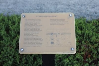
Arrowheads found during construction of this trail indicate that the Wampanoag hunted dear and small game in this hilly area. In addition the Indians relied upon the nearby Herring Run as a direct source of food and to fertilize their crop of corn and beans - a practice later adapted by Pilgrim farmers.
Staghorn Sumac, the low tree surrounding you, provided a refreshing drink made from its red berries, only one of the many fruits important to the Indian diet.
Erected by U.S. Army Corps of Engineers.
Topics. This historical marker is listed in these topic lists: Indigenous Peoples and Communities • Settlements & Settlers.
Location. Marker has been reported missing. It was located near 41° 46.321′ N, 70° 33.779′ W.
this page online

Regionally, this marker was on Massachusetts’ Cape Cod. It was also in the American Northeast, in New England, and on the Eastern Seaboard. Globally, it was in the North Atlantic Region, North America, the Western Hemisphere, the Western World, and the Anglosphere. Historically, it found itself in what was once one of the original Thirteen Colonies.
Other nearby markers. At least 8 other markers are within 3 miles of this location, measured as the crow flies: Burying Hill (approx. 0.2 miles away); Still on Patrol (approx. ¼ mile away); Cape Cod Canal (approx. half a mile away); August Belmont (approx. half a mile away); William Barclay Parsons (approx. half a mile away); Monica Dickens Stratton (approx. half a mile away); a different marker also named The Cape Cod Canal
Photographed by Bryan Simmons, July 2012
2. Comassakumakanit Marker
Another marker is no longer nearby. Bournedale's Yesterdays (was a few steps from this marker but has been confirmed missing).
Credits. This page was last revised on June 10, 2023. It was originally submitted on July 15, 2012, by Bryan Simmons of Attleboro, Massachusetts. This page has been viewed 1,167 times since then and 42 times this year. Last updated on June 10, 2023, by Greg Golfomitsos of Plymouth, Massachusetts. Photos: 1, 2. submitted on July 15, 2012, by Bryan Simmons of Attleboro, Massachusetts. • J. Makali Bruton was the editor who published this page.
