Beaufort in Carteret County, North Carolina — The American South (South Atlantic)
Remembering our Ancestors
African Presence & The Middle Passage
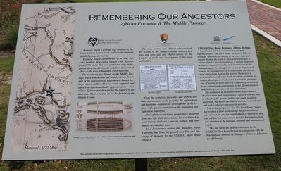
Beaufort, North Carolina, was involved in the Trans-Atlantic human trade and is a documented Middle Passage arrival site.
Enslaved people disembarked at or neat this exact location, now called Topsail Park. Records from 1769 show that one particular ship transported thirty-six Africans directly from the coast of Africa to the Port of Beaufort, North Carolina.
The ocean voyage, known as the Middle Passage, was a treacherous and brutal journey. It was part of the largest forced migration in human history; twelve million Africans were captured and taken from their homeland. Approximately two million Africans perished during the journey to the Americas. Their remains lie at the bottom of the Atlantic Ocean.
The men, women, and children who survived the voyage of the Middle Passage disembarked here and were sold into chattel slavery for the purpose of profit and development of this town and nation.
Over the centuries, these men and women, and their descendants made possible the agricultural and maritime commercial development of the region, with special emphasis on the menhaden and turpentine industries.
Although these enslaved people have departed from this life, their descendants have continued to contribute to the town's success, culture, and community in countless ways.
As a documented arrival site, Beaufort, North Carolina, has been designated as a Site and Itinerary of Memory by the UNESCO Slave Route Project.
UNESCO Slave Route: Resistance, Liberty, Heritage
Launched in 1994, the international and interregional project ‘The Slave Route: Resistance Liberty, Heritage’ addresses the history of the slave trade and slavery through the prism of intercultural dialogue, a culture of peace and reconciliation. It thereby endeavors to improve the understanding and transmission of this human tragedy by making better known its deep-seated causes, its consequences for societies today and the cultural interactions born of this history. The project is structured around five key fields of activity: scientific research, development of educational materials, preservation of written archives and oral traditions, promotion of living cultures and contributions by the African diaspora and, lastly, preservation of sites of memory.
The promotion of the memorial heritage related to the slave trade and slavery plays a decisive role not only in educating the general public, and young people in particular, but also in facilitating national reconciliation and social cohesion processes in societies.
It is in this perspective that The Slave Route Project has created a label to encourage the preservation of sites of memory and

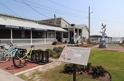
Photographed By Dave W, June 10, 2023
2. Remembering our Ancestors Marker
UNESCO "Routes of Enslaved Peoples: Resistance, Liberty and Heritage" Project
Click for more information.
Click for more information.
This site fulfils the quality criteria set by the UNESCO Slave Route Project in conjunction with the International Network of Managers of Sites and Itineraries of Memory.
Erected by Beaufort, North Carolina's Middle Passage Project Committee; a division of Eastern Carolina Foundation for Equity and Equality, Inc.
Topics. This historical marker is listed in these topic lists: African Americans • Colonial Era • Waterways & Vessels. A significant historical year for this entry is 1769.
Location. 34° 43.061′ N, 76° 40.036′ W. Marker is in Beaufort, North Carolina, in Carteret County. Marker is at the intersection of Front Street and Orange Street, on the right when traveling east on Front Street. Located in Topsail Marine Memorial Park. Touch for map. Marker is at or near this postal address: 220 Front St, Beaufort NC 28516, United States of America. Touch for directions.
Other nearby markers. At least 8 other markers are within walking distance of this marker. Jacob Henry (within shouting distance of this marker); USS Monitor: America's First Ironclad (about 300 feet away, measured in a direct line); Beaufort (about 600 feet away); Michael John Smith (about 700 feet away); John G. Newton (approx. 0.2 miles away); Old Burying Ground (approx. 0.2 miles away); Whale Fishery (approx. ¼ mile away); Cateret County Gold Star Families Memorial Monument (approx. ¼ mile away). Touch for a list and map of all markers in Beaufort.
Credits. This page was last revised on August 16, 2023. It was originally submitted on June 15, 2023, by Dave W of Co, Colorado. This page has been viewed 102 times since then and 17 times this year. Photos: 1, 2. submitted on June 15, 2023, by Dave W of Co, Colorado. • Bernard Fisher was the editor who published this page.
