Swope Parkway - Elmwood in Kansas City in Jackson County, Missouri — The American Midwest (Upper Plains)
Battle of the Big Blue, October 22, 1864
| — | Battle of Westport • Byram's Ford • Big Blue Battlefield • 22-23 October 1864 | — |
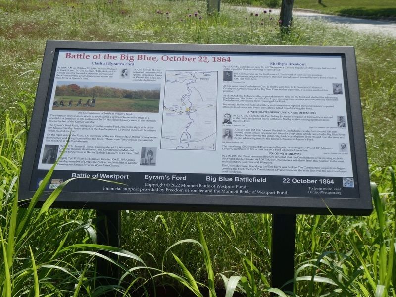
Photographed by Robert Macoubrie, June 22, 2023
1. Battle of the Big Blue, October 22, 1864
(captions)
Lt. Col. George H. Hoyt seasoned commander of special operations forces of Kansas Red Legs, and staunch abolitionist.
2014 Reenactment of battle at Byram's Ford.
The skirmish line ran from north to south along a split rail fence at the edge of a cornfield. A battalion of 300 soldiers of the 3rd Wisconsin Cavalry were in the skirmish line to the left of the Kansas Cavalry.
The Byram's Ford Road, emerging from the nearby Ford, ran on the right side of the 15th Kansas Cavalry. In the center of the Road were two 12-pound mountain howitzers which blasted the Ford.
On the right side of the Road, 130 members of the 4th Kansas State Militia cavalry were dismounted and firing from behind the fence. There were 750 troops in the skirmish line shooting at the Confederates.
(captions)
[Left] 1st Lt. James B. Pond. Commander of 3rd Wisconsin Cavalry, staunch abolitionist, and Congressional Medal of Honor for heroism at Baxter Springs Massacre in October 1863.
[Right] Cpl. William H. Harrison Grinter. Co. E, 15th Kansas Cavalry, member of Delaware Nation, and resident of Grinter Crossing on Kansas River in Wyandotte County.
this page online
The Confederates on the bluff were a 1/2 mile east of your current position. Thompson's brigade descended the bluff and advanced toward Byram's Ford which is 1200 feet from here.
At this same time, Confederate Gen. Jo Shelby with Col. B.F. Gordon's 5" Missouri Cavalry of 300 men crossed the Big Blue River farther upstream, 1 ½ miles south of this position.
At 11:00 AM, the Federal artillery opened fire from here on the Ford and shelled the advancing Confederates. The Federal skirmishers began shooting their carbines and successfully halted the Confederates, preventing their crossing of the Ford.
For several hours, the Federal artillery and skirmishers repelled the Confederates' repeated attempts to advance and break through the felled trees blocking the Ford.
Also at 12:30 PM Col. Alonzo Slayback's Confederate cavalry battalion of 300 men moved down stream one mile and found a deep defile which ran into the Big Blue River. Hidden from view by the defile, Slayback's cavalrymen soon crossed over the river and began advancing toward the Union defenders at Byram's Ford.
The remaining 1200 troops of Thompson's Brigade, including the 11th and 12th Missouri Cavalry, continued to fire across Byram's Ford upon the Union line.
The Union defensive line along the Blue River was broken. The Confederate wagon train began crossing the Ford. Shelby's Confederates advanced toward the state line over the next two hours until sundown.
To learn more, visit BattleofWestport.org
Erected 2022 by Freedom's Frontier and the Monnett Battle of Westport Fund.
Topics. This historical marker is listed in this topic list: War, US Civil. A significant historical date for this entry is October 22, 1864.
Location. 39° 0.968′ N, 94° 31.591′ W. Marker is in Kansas City, Missouri, in Jackson County. It is in Swope Parkway - Elmwood. It can be reached from Manchester Trafficway half a mile north of East 63rd Street Trafficway when traveling north. Touch for map. Marker is at or near this postal address: 6000 Manchester Trafficway, Kansas City MO 64130, United States of America. Touch for directions.

Regionally, this marker is in the American Midwest, in the Lewis & Clark Corridor, in the Corn Belt, and on the Santa Fe Trail Corridor. Globally, it is in North America, the Western Hemisphere, the Western World, and the Anglosphere. Historically, it finds itself in what was once the territory of the Mississippian Culture, the Louisiana Purchase, and the Antebellum South.
Other nearby markers. At least 8 other markers are within walking distance of this marker: Taking Bloody Hill (about 300 feet away, measured in a direct line); Battle of the Big Blue, October 23, 1864 (about 300 feet away); Saving Kansas City's Battlefield (about 300 feet away); a different marker also named Battle of the Big Blue (about 300 feet away); Byram's Ford Battlefield (about 400 feet away); a different marker also named Battle of the Big Blue (about 600 feet away); The Log House, October 23, 1864 (approx. 0.2 miles away); The Battle of Westport, October 21-23, 1864 (approx. 0.2 miles away). Touch for a list and map of all markers in Kansas City.
Also see . . . The Battle of Westport. Battle of Westport Fund (Submitted on June 25, 2023.)
Credits. This page was last revised on October 22, 2024. It was originally submitted on June 23, 2023, by Robert Macoubrie of Lenexa, Kansas. This page has been viewed 617 times since then and 60 times this year. Photo 1. submitted on June 23, 2023, by Robert Macoubrie of Lenexa, Kansas. • Bernard Fisher was the editor who published this page.
Editor’s want-list for this marker. Wide shot of marker and its surroundings. Precise GPS coordinates. • Can you help?
