Old City in Philadelphia in Philadelphia County, Pennsylvania — The American Northeast (Mid-Atlantic)
A Changing Neighborhood
Independence National Historical Park
— National Park Service, U.S. Department of the Interior —
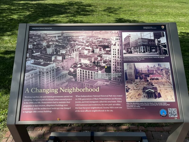
Working together, city and federal governments carried out sweeping changes as part of a broad urban renewal project in the 1950s and 60s. Homeowners had to maintain their properties or face eviction, dilapidated buildings were demolished, and the architectural landscape was changed to highlight the 18th century buildings.
When Independence National Historical Park was created in 1948, generations of Black Philadelphians and Russian, Jewish and Irish immigrants called this area home. Filled with businesses and residences, the new park sat within this busy but poor neighborhood. Society Hill is now one of the most affluent neighborhoods in the city.
[Captions:]
View of Carpenters' Hall and the Second Bank of the United States. You are standing at the approximate location of the yellow dot.
Independence National Historical Park, 1950
The northeast corner of 4th and Chestnut Streets. Notice the signage announcing demolition in the area.
Independence National Historical Park, 1954
After the demolition work, the First Bank of the United States and Carpenters' Hall stood isolated, awaiting the landscaping that surround you today.
Independence National Historical Park, 1959
Erected 2023 by National Park Service, U.S. Department of the Interior.
Topics. This historical marker is listed in these topic lists: African Americans • Architecture • Immigration • Parks & Recreational Areas • Settlements & Settlers. A significant historical year for this entry is 1948.
Location. 39° 56.861′ N, 75° 8.855′ W. Marker is in Philadelphia, Pennsylvania, in Philadelphia County. It is in Old City. Marker can be reached from Walnut Street (County Road 3006) east of South 4th Street, on the right when traveling west. Touch for map. Marker is at or near this postal address: 341 Walnut Street, Philadelphia PA 19106, United States of America. Touch for directions.
Other nearby markers. At least 8 other markers are within walking distance of this marker. A Working-Class House in the Capital City (within shouting distance of this marker); 18th Century Garden (within shouting distance of this marker); James Madison 4th President lived here (within shouting distance of this marker); Carpenters' Hall (within shouting distance of this marker); A Backyard in the Capital City (within shouting distance of this marker); Old St. Joseph's Roman Catholic Church (within shouting distance of this marker); Todd House (within shouting distance of this marker); Historic Dock Creek (within shouting distance of this marker). Touch for a list and map of all markers in Philadelphia.
Additional keywords. urban displacement; urban renewal; historic preservation
Credits. This page was last revised on July 4, 2023. It was originally submitted on July 4, 2023, by Devry Becker Jones of Washington, District of Columbia. This page has been viewed 50 times since then and 8 times this year. Photos: 1, 2. submitted on July 4, 2023, by Devry Becker Jones of Washington, District of Columbia.

