Mission Viejo in Orange County, California — The American West (Pacific Coastal)
Mission Viejo
Make Volunteering you Mission
Photographed by Adam Margolis, June 27, 2023
1. Mission Viejo Marker
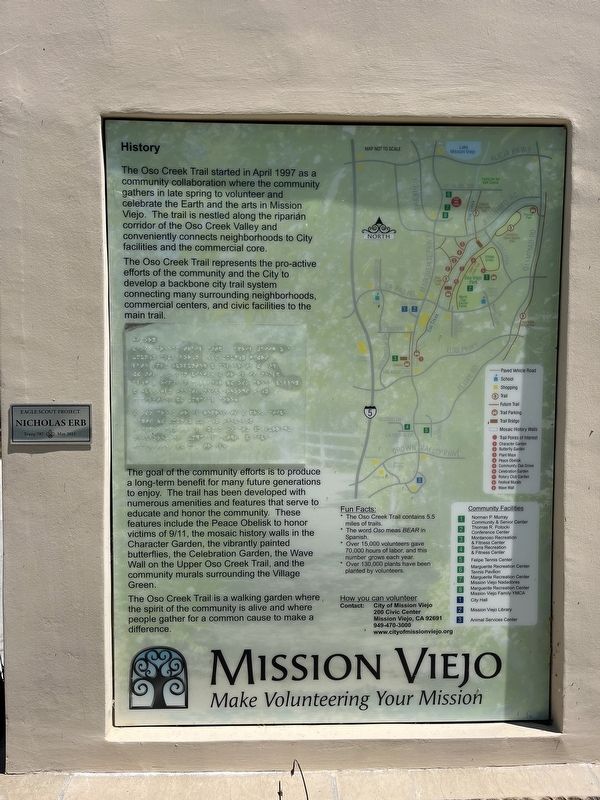
The Oso Creek Trail started in April 1997 as a community collaboration where volunteers gather in late spring to celebrate the Earth and the arts in Mission Viejo. The trail is nestled along the riparian corridor of the Oso Creek Valley and conveniently connects residence to City facilities, the commercial core and surrounding neighborhoods.
The Oso Creek Trail represents the pro-active efforts of the community and the City to develop a backbone city trail system.
The goal of the community efforts is to produce a long-term benefit for many future generations to enjoy. The trail has been developed with numerous amenities and features that serve to educate and honor the community. These features include the Peace Obelisk to honor victims of 9/11, the mosaic history walls in the Character Garden, the vibrantly painted butterflies, the Celebration Garden, the Wave Wall on the Upper Oso Creek Trail, and the community murals surrounding the Village Green.
The Oso Creek Trail is a walking garden where the spirit of the community is alive and where people gather for a common cause to make a difference.
Erected 2013
this page online
Topics. This historical marker is listed in these topic lists: Charity & Public Work • Parks & Recreational Areas. A significant historical month for this entry is April 1997.
Location. 33° 36.948′ N, 117° 39.105′ W. Marker is in Mission Viejo, California, in Orange County. It can be reached from Marguerite Parkway. Touch for map. Marker is at or near this postal address: 23840 Marguerite Pkwy, Mission Viejo CA 92692, United States of America. Touch for directions.

Regionally, this marker is in Greater Los Angeles and in the Peninsular Ranges. It is also on the American Pacific Coast. Globally, it is in North America, on the Ring of Fire, on the Pacific Rim, in the Western Hemisphere, in the Western World, and in the Anglosphere. Historically, it finds itself in what was once New Spain and also Mexico’s Alta California.
Other nearby markers. At least 8 other markers are within one mile of this marker, measured as the crow flies: Mountain Wall (approx. 0.7 miles away); Carving Farmland into a Lake (approx. 0.8 miles away); Farming the Upper Oso Lease (approx. 0.8 miles away); Lake Mission Viejo Advanced Purified Water Project
Photographed by Adam Margolis, June 27, 2023
2. Mission Viejo Marker
Photographed by Adam Margolis, June 27, 2023
3. Mission Viejo Marker
Credits. This page was last revised on August 14, 2023. It was originally submitted on July 12, 2023, by Adam Margolis of Mission Viejo, California. This page has been viewed 288 times since then and 51 times this year. Photos: 1, 2, 3. submitted on July 12, 2023, by Adam Margolis of Mission Viejo, California. • Bill Pfingsten was the editor who published this page.
