Metamora in Franklin County, Indiana — The American Midwest (Great Lakes)
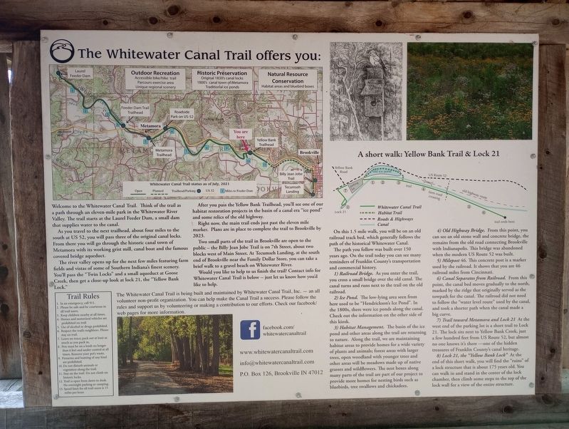
The Whitewater Canal Trail Offers You:
Yellow Banks Trail & Lock 21
Welcome to the Whitewater Canal Trail. Think of the trail as a path through an eleven-mile park in the Whitewater River Valley. The trail starts at the Laurel Feeder Dam, a small dam that supplies water to the canal.
As you travel to the next trailhead, about four miles to the south at US 52, you will pass three of the original canal locks. From there you will go through the historic canal town of Metamora with its working grist mill, canal boat and the famous covered bridge aqueduct.
The river valley opens up for the next few miles featuring farm fields and vistas of some of Southern Indiana's finest scenery. You'll pass the "Twin Locks" and a small aqueduct at Goose Creek, then get a close-up look at lock 21, the "Yellow Bank Lock."
After you pass the Yellow Bank Trailhead, you'll see one of our habitat restoration projects in the basin of a canal era "ice pond" and some relics of the old highway.
Right now, the main trail ends just past the eleven mile marker. Plans are in place to complete the trail to Brookville by 2023.
Two small parts of the trail in Brookville are open to the public - the Billy Jean Jobe Trail is on 7th Street, about two blocks west of Main Street. At Tecumseh Landing, at the south end of Brookville near the Family Dollar Store, you can take a brief walk to a gravel beach on Whitewater River.
Would you like to help to us finish the trail? Contact info for Whitewater Canal Trail is below -- just let us know how you'd like to help.
A short walk: Yellow Bank Trail & Lock 21
On this 1.5 mile walk, you will be on an old railroad track bed, which generally follows the path of the historical Whitewater Canal.
The path you follow was built over 150 years ago. On the trail today you can see many reminders of Franklin County's transportation and commercial history.
1) Railroad Bridge. As you enter the trail, you cross a small bridge over the old canal. The canal turns and runs next to the trail on the old railroad.
2) Ice Pond. The low-lying area seen from here used to be "Hendrickson's Ice Pond". In the 1800s, there were ice ponds along the canal. Check out the information on the other side of this kiosk.
3) Habitat Management. The basin of the ice pond and other areas along the trail are returning to nature. Along the trail, we are maintaining habitat areas to provide homes for a wide variety of plants and animals; forest areas with larger trees, open woodland with younger trees and other areas will be meadows made up of native grasses and wildflowers. The nest boxes along many parts of the trail are part of our project to provide more homes for nesting birds such as bluebirds, tree swallows and chickadees.
4) Old Highway Bridge. From this point, you can see an old stone wall and concrete bridge, the remains from the old road connecting Brookville with Indianapolis. This bridge was abandoned when the modern US Route 52 was built.
5) Milepost 46. This concrete post is a marker used by the railroad. It shows that you are 46 railroad miles from Cincinnati.
6) Canal Separates from Railroad. From this point, the canal bed moves gradually to the north, marked by the ridge that originally served as the towpath for the canal. The railroad did not need to follow the "water level route” used by the canal, and took a shorter path when the canal made a big curve.
7) Trail toward Metamora and Lock 21. At the west end of the parking lot is a short trail to Lock 21. The lock sits next to Yellow Bank Creek, just a few hundred feet from US Route 52, but almost no one knows it's there one of the hidden treasures of Franklin County's canal heritage.
8) Lock 21, the "Yellow Bank Lock”. At the end of this short walk, you will find the "ruins” of a lock structure that is about 175 years old. You can walk in and stand in the center of the lock chamber, then climb some steps to the top of the lock wall for a view of the entire structure.
Topics. This historical marker is listed in these topic lists: Bridges & Viaducts • Parks & Recreational Areas • Railroads & Streetcars • Waterways & Vessels.
Location. 39° 26.264′ N, 85° 3.569′ W. Marker is in Metamora, Indiana, in Franklin County. Marker is on U.S. 52, 0.1 miles east of Yellow Bank Road, on the right when traveling east. Touch for map. Marker is at or near this postal address: 15040 Route 52, Brookville IN 47012, United States of America. Touch for directions.
Other nearby markers. At least 8 other markers are within 3 miles of this marker, measured as the crow flies. Yellow Bank Flag Stop / Hendrickson's Ice Pond (here, next to this marker); a different marker also named The Whitewater Canal Trail Offers You: (about 300 feet away, measured in a direct line); Lock 21 and the Twin Arch Aqueduct at Yellow Bank Creek (about 800 feet away); Boundary Hill (approx. 1.1 miles away); Intersection of Treaty Lines (approx. 2.1 miles away); David Stoops - Pioneer (approx. 2.3 miles away); Brookville's Carnegie Library (approx. 2.7 miles away); Goodwin Home (approx. 2.7 miles away). Touch for a list and map of all markers in Metamora.
Credits. This page was last revised on July 28, 2023. It was originally submitted on July 21, 2023, by Craig Doda of Napoleon, Ohio. This page has been viewed 57 times since then and 14 times this year. Photos: 1, 2. submitted on July 21, 2023, by Craig Doda of Napoleon, Ohio. • Devry Becker Jones was the editor who published this page.

