Brookville Township near Metamora in Franklin County, Indiana — The American Midwest (Great Lakes)
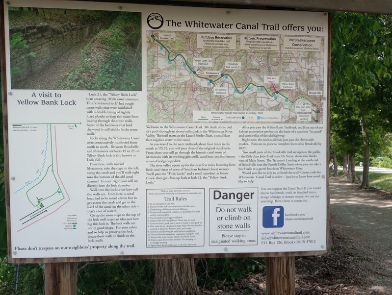
The Whitewater Canal Trail Offers You:
Lock 21, the "Yellow Bank Lock" is an amazing 1830s canal structure. This "combined lock" had rough stone walls that were combined with a double lining of tightly fitted planks to keep the water from leaking through the stone walls. Some of the hardware that held the wood is still visible in the stone walls.
Locks along the Whitewater Canal were consecutively numbered from south to north. Between Brookville and Metamora are locks 19 to 25. so Yellow Bank lock is also known as Lock # 21.
From here, walk toward Metamora, take the steps to the left, along the creek and you'll walk right into the bottom of the old canal channel. To your right, you will see directly into the lock chamber.
Walk into the lock to see how tall the walls are. From here, a canal boat had to be raised eleven feet to get across the creek and get to the level of the canal on the other side- that's a lot of water!
Go up the stone steps to the top of the lock wall to get an idea just how big this lock is. The lock walls are not in good shape. For your safety and to help us preserve the lock, please don't walk or climb on the lock. walls.
Welcome to the Whitewater Canal Trail. We think of the trail as a path through an eleven-mile park in the Whitewater River Valley. The trail starts at the Laurel Feeder Dam, a small dam that supplies water to the canal.
As you travel to the next trailhead, about four miles to the south at US 52, you will pass three of the original canal locks. From there you will go through the historic canal town of Metamora with its working grist mill, canal boat and the famous covered bridge aqueduct.
The river valley opens up for the next few miles featuring farm fields and vistas of some of Southern Indiana's finest scenery. You'll pass the "Twin Locks” and a small aqueduct at Goose Creek, then get close-up look at lock 21, the "Yellow Bank Lock."
After you pass the Yellow Bank Trailhead, you'll see one of our habitat restoration projects in the basin of a canal era "ice pond" and some relics of the old highway.
Right now, the main trail ends just past the eleven mile marker. Plans are in place to complete the trail to Brookville by 2023.
Two small parts of the Brookville trail are open to the public - the Billy Jean Jobe Trail is on 7th Street, about two blocks west of Main Street. The Tecumseh Landing at the south end of Brookville near the Family Dollar Store where you can take a brief walk to a gravel beach on Whitewater River.
Would you like to help to us finish the trail? Contact info for Whitewater Canal Trail is below -- just let us know how you'd like to help.
Topics. This historical marker is listed in these topic lists: Parks & Recreational Areas • Waterways & Vessels.
Location. 39° 26.262′ N, 85° 3.627′ W. Marker is near Metamora, Indiana, in Franklin County. It is in Brookville Township. Marker is on U.S. 52 east of Yellow Bank Road, on the right when traveling east. Touch for map. Marker is at or near this postal address: 15040 Route 52, Brookville IN 47012, United States of America. Touch for directions.
Other nearby markers. At least 8 other markers are within 3 miles of this marker, measured as the crow flies. A different marker also named The Whitewater Canal Trail Offers You: (about 300 feet away, measured in a direct line); Yellow Bank Flag Stop / Hendrickson's Ice Pond (about 300 feet away); Lock 21 and the Twin Arch Aqueduct at Yellow Bank Creek (about 500 feet away); Boundary Hill (approx. 1.1 miles away); Intersection of Treaty Lines (approx. 2.1 miles away); David Stoops - Pioneer (approx. 2.4 miles away); Brookville's Carnegie Library (approx. 2.7 miles away); Goodwin Home (approx. 2.7 miles away). Touch for a list and map of all markers in Metamora.
Credits. This page was last revised on July 28, 2023. It was originally submitted on July 21, 2023, by Craig Doda of Napoleon, Ohio. This page has been viewed 48 times since then and 11 times this year. Photos: 1, 2. submitted on July 21, 2023, by Craig Doda of Napoleon, Ohio. • Devry Becker Jones was the editor who published this page.

