Blowing Rock in Watauga County, North Carolina — The American South (South Atlantic)
Blowing Rock's History
| — | Blowing Rock History Walk | — |
Photographed by Duane and Tracy Marsteller, June 24, 2023
1. Blowing Rock's History Marker
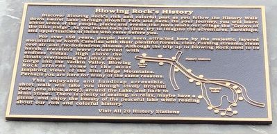
For over 150 years, people have been attracted here by the majestic, layered mountains of North Carolina with their plentiful forests, clear, rushing streams, clean cool air, and rhododendron blooms. Although the trip up to Blowing Rock used to be harsh, travelers were rewarded with endless vistas. High above the clouds overlooking the John's River Gorge and the Yadkin Valley, Blowing Rock affords some of the most inspiring views of the Blue Ridge Mountains. Perhaps you are here for many of the same reasons.
This enjoyable and handicap accessible, short walk will take you through lovely Broyhill Park (one block away), around the Lake, and back to Main Street. There is plenty of seating, so relax, maybe have a picnic, and enjoy
this page online
Caption: Visit All 20 History Stations
Erected by Blowing Rock Historical Society • Blowing Rock Village Foundation • Town of Blowing Rock.
Topics. This historical marker is listed in these topic lists: Education • Parks & Recreational Areas.
Location. 36° 7.937′ N, 81° 40.718′ W. Marker is in Blowing Rock, North Carolina, in Watauga County. It is at the intersection of Laurel Lane and Main Street (Business U.S. 321), on the right when traveling west on Laurel Lane. Touch for map. Marker is at or near this postal address: 1116 Main St, Blowing Rock NC 28605, United States of America. Touch for directions.

Regionally, this marker is in andspecifically he Mountains in the High Country. It is also in the American South, specifically in the Upper South, in Appalachia, and specifically in Southern Appalachia. Globally, it is in North America, the Western Hemisphere, the Western World, and the Anglosphere. Historically, it finds itself in what was once the original Cherokee Nation,
Photographed by Duane and Tracy Marsteller, June 24, 2023
2. Blowing Rock's History Marker
Other nearby markers. At least 8 other markers are within walking distance of this marker: Appalachian Ski Mountain (here, next to this marker); Main Street Through the Years (a few steps from this marker); Blowing Rock Charity Horse Show (a few steps from this marker); Mayview Manor Hotel (a few steps from this marker); Tweetsie Railroad (a few steps from this marker); Martin House (within shouting distance of this marker); Sonny's Grill (within shouting distance of this marker); Early Visitors and Settlers (within shouting distance of this marker). Touch for a list and map of all markers in Blowing Rock.
Also see . . . Backstory: Blowing Rock's History (PDF). Did you know the village’s first mayor drove a stampede of cattle down Main Street? Or that infamous sharpshooter Annie Oakley showcased her skills at Mayview Manor? Or that a tiny version of Tweetsie Railroad (the Tweetsie Junior) used to circle around Mayview Lake and could carry children and adults? Delve into these stories and more with the History Walk and its paired online backstories. (Blowing Rock Historical Society) (Submitted on July 23, 2023, by Duane and Tracy Marsteller of Murfreesboro, Tennessee.)
Credits. This page was last revised on July 24, 2023. It was originally submitted on July 22, 2023, by Duane and Tracy Marsteller of Murfreesboro, Tennessee. This page has been viewed 247 times since then and 38 times this year. Photos: 1, 2. submitted on July 22, 2023, by Duane and Tracy Marsteller of Murfreesboro, Tennessee.
