Hiawassee in Towns County, Georgia — The American South (South Atlantic)
Logan Turnpike
— Chattahoochee-Oconee National Forests —
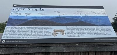
Previously isolated communities now had the opportunity to trade produce, livestock and forest products such as ginseng and chestnuts for store-bought' items such as coffee, sugar and shoes. The road, so steep and rugged, would often require wagons to drag fair sized trees behind them to keep form running over the horses. Logan's Turnpike remained well used into the 1920s until the road was abandoned after the completion of a paved road across Neel's Gap to the south for easier automobile access.
(photo legend)
Helen, Ga 13 miles
Yonah Mtn 3,166'
Jack's Knob 3,805'
Cleveland, Ga 20 miles
Walker Mtn 2,585'
Horsetrough Man 4,045'
Wildcat Man 3,760'
Rocky Mtn 4,191'
Tesnatee Gap
Cowrock Man 3,852'
Logan Turnpike
Wolf Laurel Top 3,760'
Frozentop 3,160'
Dahlonega, Ga 25 miles
Skyline of Atlanta 80 miles
USDA is an equal opportunity provider and employer
Erected by United States Department of Agriculture.
Topics. This historical marker is listed in these topic lists: Industry & Commerce • Parks & Recreational Areas • Roads & Vehicles. A significant historical year for this entry is 1821.
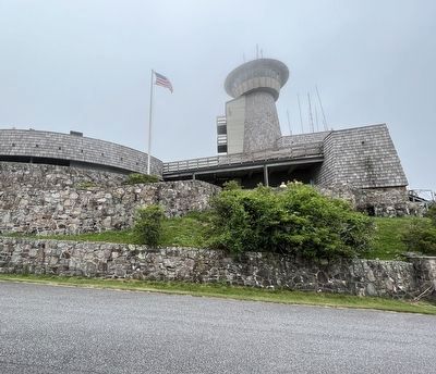
Location. 34° 52.456′ N, 83° 48.637′ W. Marker is in Hiawassee, Georgia, in Towns County. Marker can be reached from Georgia Route 180 Spur, 9 miles north of Georgia Route 180. Located at the Brasstown Bald Visitors Center. Touch for map. Marker is at or near this postal address: 2941 GA-180 Spur, Hiawassee GA 30546, United States of America. Touch for directions.
Other nearby markers. At least 8 other markers are within 6 miles of this marker, measured as the crow flies. Gold Rush Spurs Cherokee Removal (a few steps from this marker); Designated Wilderness (within shouting distance of this marker); Returning Fire to the Mountains (within shouting distance of this marker); Appalachian Trail (within shouting distance of this marker); Brasstown Bald (about 300 feet away, measured in a direct line); Track Rock Gap (approx. 3.8 miles away); a different marker also named Brasstown Bald (approx. 5.4 miles away); Towns County (approx. 5.9 miles away). Touch for a list and map of all markers in Hiawassee.
Also see . . . Brasstown Bald Visitor Information Center. Forest Service USDA (Submitted on July 29, 2023.)
Credits. This page was last revised on July 29, 2023. It was originally submitted on July 26, 2023, by Sandra Hughes Tidwell of Killen, Alabama, USA. This page has been viewed 101 times since then and 42 times this year. Photos: 1, 2. submitted on July 26, 2023, by Sandra Hughes Tidwell of Killen, Alabama, USA. • Bernard Fisher was the editor who published this page.

