
Near Nassau in Rensselaer County, New York — The American Northeast (Mid-Atlantic)
Empire State Trail
at Nassau Lake
Photographed by Steve Stoessel, July 29, 2023
1. Empire State Trail Marker, Side One
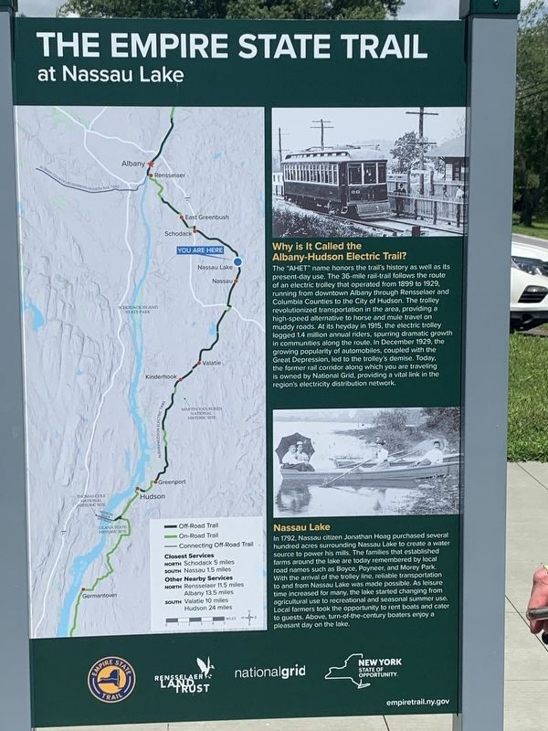
Why is It Called the Albany-Hudson Electric Trail?
The "AHET" name honors the trail's history as well as its present-day use. The 36-mile rail-trail follows the route of an electric trolley that operated from 1899 to 1929. running from downtown Albany through Rensselaer and Columbia Counties to the City of Hudson. The trolley revolutionized transportation in the area, providing a high-speed alternative to horse and mule travel on muddy roads. At its heyday in 1915, the electric trolley logged 1.4 million annual riders, spurring dramatic growth in communities along the route. In December 1929, the growing popularity of automobiles, coupled with the Great Depression, led to the trolley's demise. Today. the former rail corridor along which you are traveling is owned by National Grid, providing a vital link in the region's electricity distribution network
Nassau Lake
In 1792, Nassau citizen Jonathan Hoag purchased several hundred acres surrounding Nassau Lake to create a water source to power his mills. The families that established farms around the lake are today remembered by local road names such as Boyce, Poyneer,
this page online
(opposite side)
The 750-mi Empire State Trail connects people to New York's spectacular natural beauty, cultural heritage. iconic landscapes, and unparalleled outdoor recreation opportunities. The Trail promotes healthy lifestyles and provides a place for friends and families to experience the Empire State's special places and rich diversity - connecting urban centers, village main streets, and rural communities from New York City through the Hudson River Valley, west to Buffalo along the historic Erie Canal, and north to the Champlain Valley and Adirondacks
Enjoy the journey
empiretrail.ny.gov
Erected by Empire State Trail, National Grid, Rensselaer Land Trust.
Topics. This historical marker is listed in these topic lists: Railroads & Streetcars

Photographed by Steve Stoessel, July 29, 2023
2. Empire State Trail Marker, Side Two
Location. 42° 32.125′ N, 73° 36.519′ W. Marker is near Nassau, New York, in Rensselaer County. It is on Schodack-Nassau Road (County Route 7) north of Old Forge Road, on the right when traveling south. Marker is at the parking lot for Albany-Hudson Electric Trail beside Nassau Lake. Touch for map. Marker is at or near this postal address: 217 Schodack-Nassau Road, Nassau NY 12123, United States of America. Touch for directions.

Regionally, this marker is in Upstate New York, in the Capital District, and in the Albany Metropolitan Area. It is also in the American Northeast and in the Mid-Atlantic. Globally, it is in North America, the Western Hemisphere, the Western World, and the Anglosphere. Historically, it finds itself in what was once New Netherland and also one of the original Thirteen Colonies.
Other nearby markers. At least 8 other markers are within 4 miles of this marker, measured as the crow flies: Mohican Homelands (here, next to this marker); Passenger and Freight Depots (approx. 1.2 miles away); Nassau Academy
Photographed by Steve Stoessel, July 22, 2023
3. Empire State Trail Marker
Also see . . . Empire State Trail Description and map. (Submitted on August 9, 2023, by Steve Stoessel of Niskayuna, New York.)
Credits. This page was last revised on August 15, 2023. It was originally submitted on August 9, 2023, by Steve Stoessel of Niskayuna, New York. This page has been viewed 202 times since then and 17 times this year. Photos: 1, 2, 3. submitted on August 9, 2023, by Steve Stoessel of Niskayuna, New York. • Michael Herrick was the editor who published this page.
