Litchfield in Litchfield County, Connecticut — The American Northeast (New England)
Stone Walls / Chestnut Grove / Wet Meadow
Inscription.
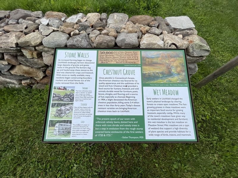
Stone Walls
as increased farming began to change Litchfield's landscape, farmers discovered large deposits of granite and gneiss rocks in the ground. The farmers dug up and hauled away these stones as the land was cleared for crops and livestock. With stone so readily available, many residents began constructing boundary markers and animal fences out of the rocks removed from the fields.
Thrown
The most rudimentary stone wall is a "thrown" or "tossed" wall, a simple row of piled stones at the edge of a field or pasture. These walls require little experience to build but need regular upkeep.
Stacked
Most old New England walls are "stacked" walls, in which the stones are stacked neatly like firewood. Fore added stability, farmers could stack two parallel rows of stones, leaning against one another.
Laid
The presence of a mason or quarryman allowed for the construction of a "laid" wall, a more stable and elegant wall made from cut or quarried stones layered in a weave pattern.
Chestnut Grove
Once plentiful in Connecticut's forests, the American chestnut was favored for its quality, appearance, and the usefulness of its wood and fruit. Chestnut trees provided a food source for humans, livestock, and wild animals; durable wood for furniture, posts, fences, shingles, and flooring; and a source of fuel, especially as charcoal. Beginning in 1904, a blight devastated the American chestnut population, killing some 3.4 billion trees in less than forty years. Today's disease resistant varieties are bringing American chestnut trees back to Litchfield.
"The present epoch of our town with unfenced, velvety lawns, dotted here and there with rare shrubs and stately trees is but a step in evolution from the rough stump covered home enclosures of the first settlers of 1720 & 1721."
- Esther Thompson, 1920
Wet Meadow
Early settlers in Litchfield changed the town's physical landscape by clearing forests to create open meadows. The fast-growing grasses in these meadows were an important food source for grazing livestock, especially cattle. While many of the town's meadows have given way to residential development and farmland, this wet meadow is the last meadow on Meadow Street. Wet meadows are a type of wetland that support a high diversity of plant species and provide habitats for a wide range of birds, insects, and mammals.
Erected by Litchfield Historical Society.
Topics. This historical marker is listed in these topic lists: Architecture
• Colonial Era • Horticulture & Forestry • Natural Features • Natural Resources • Settlements & Settlers. A significant historical year for this entry is 1904.
Location. 41° 44.64′ N, 73° 11.373′ W. Marker is in Litchfield, Connecticut, in Litchfield County. Marker can be reached from South Street (Connecticut Route 65) north of Wolcott Street, on the right when traveling south. Touch for map. Marker is at or near this postal address: 58 South St, Litchfield CT 06759, United States of America. Touch for directions.
Other nearby markers. At least 8 other markers are within walking distance of this marker. The Garden (a few steps from this marker); The Orchard (within shouting distance of this marker); Welcome to the Tapping Reeve Meadow (within shouting distance of this marker); Oliver Wolcott Jr. Home (approx. 0.2 miles away); Litchfield World War I Monument (approx. 0.2 miles away); Site of Recruiting Tent (approx. 0.2 miles away); War on Terrorism Memorial (approx. 0.2 miles away); Litchfield Vietnam War Monument (approx. 0.2 miles away). Touch for a list and map of all markers in Litchfield.
Credits. This page was last revised on August 9, 2023. It was originally submitted on August 9, 2023, by Devry Becker Jones of Washington, District of Columbia. This page has been viewed 43 times since then and 10 times this year. Photos: 1, 2. submitted on August 9, 2023, by Devry Becker Jones of Washington, District of Columbia.

