Near Shiloh in Hardin County, Tennessee — The American South (East South Central)
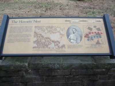
The Hornets' Nest
During the next eight hours, Confederate infantry charged the road and the wooded stronghold they called the "Hornets' Nest" eleven times. Repeatedly they were repulsed by swarms of minie balls.
A 5-minute walk down the Sunken Road leads to an exhibit on the surrender of the Hornets' Nest. The ground you will be walking over is the scene of some of the most desperate and deadly fighting in the Civil War.
Topics. This historical marker is listed in this topic list: War, US Civil.
Location. 35° 8.286′ N, 88° 20.405′ W. Marker is near Shiloh, Tennessee, in Hardin County. Marker is on Corinth-Pittsburg Landing Road, on the left when traveling west. Located at stop three, the Hornet's Nest, on the driving tour of Shiloh National Battlefield. Touch for map. Marker is in this post office area: Shiloh TN 38376, United States of America. Touch for directions.
Other nearby markers. At least 8 other markers are within walking distance of this marker. Battle Reaches Duncan's Farm (a few steps from this marker); 2d Iowa Infantry (a few steps from this marker); Battle Returns to Duncan's Farm (a few steps from this marker); 6th Indiana Infantry (within shouting distance of this marker); 15th Michigan Infantry (within shouting distance of this marker); 58th Illinois Infantry (within shouting distance of this marker); 1st Ohio Infantry (about 500 feet away, measured in a direct line); 5th Kentucky Infantry (about 500 feet away). Touch for a list and map of all markers in Shiloh.
More about this marker. In the center is a drawing depicting the fighting, with the quote: "Then the supporting infantry, rising from their recumbent position, sent fort a sheet of leaden hail that elicited curses, shrieks, groans, and shouts, all blended into an appalling cry." - Capt. Andrew Hickenlooper, 5th Ohio Independent Battery
Also in the center is a portrait of Col. Randall Gibson. Col. Randall L. Gibson, a Yale graduate, led four charges against the nearly impregnable Hornets' Nest. Each time his men were overwhelmed by murderous storms of minie balls, shot, shell, and canister.
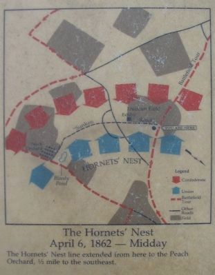
On the far right is a map of the action in this sector - The Hornets' Nest - April 6, 1862 - Midday. The Hornets' Nest line extended from here to the Peach Orchard, 1/2 mile to the southeast. At the top of the marker is a timeline showing the span of the battle, with the time of the Confederate attacks on the Hornets' Nest indicated.
Credits. This page was last revised on September 22, 2020. It was originally submitted on October 10, 2009, by Craig Swain of Leesburg, Virginia. This page has been viewed 1,549 times since then and 24 times this year. Photos: 1, 2, 3, 4. submitted on October 10, 2009, by Craig Swain of Leesburg, Virginia.


