
Westport in Bristol County, Massachusetts — The American Northeast (New England)
Legend of the Turnips

Photographed by Steven Lubar, circa 2006
1. Legend of the Turnips Marker
Erected by Town of Westport.
Topics. This historical marker is listed in these topic lists: Agriculture • Horticulture & Forestry. A significant historical year for this entry is 1876.
Location. 41° 33.26′ N, 71° 5.673′ W. Marker is in Westport, Massachusetts, in Bristol County. It is on Main Road half a mile south of Allen Way, on the right when traveling south. Touch for map. Marker is in this post office area: Westport MA 02790, United States of America. Touch for directions.

Regionally,
this page online
Other nearby markers. At least 8 other markers are within 7 miles of this marker, measured as the crow flies: Rhode Island Red (approx. 1.7 miles away in Rhode Island); Weetamoo (approx. 4½ miles away in Rhode Island); Chace-Cory House (approx. 4.9 miles away in Rhode Island); Take a Walk on Your Land (approx. 5 miles away in Rhode Island); Col. Benjamin Church (approx. 5 miles away in Rhode Island); Awashonks (approx. 6.1 miles away in Rhode Island); Summer Weeku Frame (approx. 6.3 miles away in Rhode Island); Welcome to Sakonnet (approx. 6.3 miles away in Rhode Island).
Additional keywords. vegetable, farm, garden
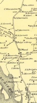
From the collection of the Westport Historical Society.
2. Macomber Turnip Farms Map
Credits. This page was last revised on June 16, 2016. It was originally submitted on October 11, 2009. This page has been viewed 4,727 times since then and 79 times this year. Photos: 1. submitted on October 11, 2009. 2. submitted on October 15, 2009. • Kevin W. was the editor who published this page.
Editor’s want-list for this marker. Confirm location. • Separate HMdb entries for other area markers. • Can you help?
