Near Houlton in St. Croix County, Wisconsin — The American Midwest (Great Lakes)
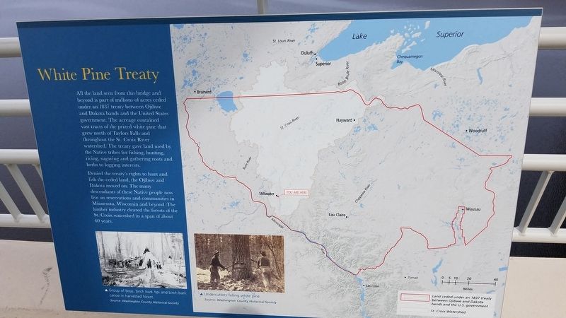
White Pine Treaty
Denied the treaty’s rights to hunt and fish the ceded land, the Ojibwe and Dakota moved on. The many decedents of these Native people now live on reservations and communities in Minnesota, Wisconsin, and beyond. The lumber industry cleared the forests in the St. Croix watershed in a span of about 60 years.
Photo captions:
{Left} Groups of boys, birch bark tipi and birch bark canoe in harvested forest.
Source: Washington County Historical Society
Undercutters felling white pine
Source: Washington County Historical Society
{Map} Red line: Land ceded under an 1837 treaty between Ojibwe and Dakota bands and the U.S. government
White area: St. Croix watershed
Erected 2017.
Topics. This historical marker is listed in these topic lists: Environment • Industry & Commerce • Native Americans.
Location. 45° 2.538′ N, 92° 47.1′ W. Marker is near Houlton, Wisconsin, in St. Croix County. Marker is on Wisconsin Route 64, on the right when traveling west. It is located along the St. Croix River Crossing Loop Trail. Touch for map. Marker is in this post office area: Hudson WI 54016, United States of America. Touch for directions.
Other nearby markers. At least 8 other markers are within walking distance of this marker. Steamboats on the St. Croix (a few steps from this marker in Minnesota); Where's the State Boundary? (a few steps from this marker in Minnesota); Migration (approx. ¼ mile away); Protecting the Watershed (approx. ¼ mile away); Home to Bald Eagles (approx. ¼ mile away); St. Croix Crossing (approx. ¼ mile away in Minnesota); Building a Bridge (approx. ¼ mile away in Minnesota); Brule-St. Croix Waterway (approx. 0.4 miles away). Touch for a list and map of all markers in Houlton.
Credits. This page was last revised on September 25, 2023. It was originally submitted on April 13, 2020, by Fitzie Heimdahl of Eau Claire, Wisconsin. This page has been viewed 235 times since then and 37 times this year. Last updated on September 25, 2023, by McGhiever of Minneapolis, Minnesota. Photos: 1, 2. submitted on April 13, 2020, by Fitzie Heimdahl of Eau Claire, Wisconsin. • Bill Pfingsten was the editor who published this page.

