Casco Antiguo in Zaragoza, Aragón, Spain — Southwestern Europe (Iberian Peninsula)
Plaza de España
Historia de Zaragoza
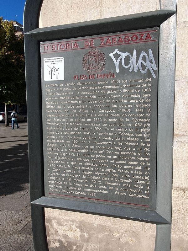
La plaza de España (llamada así desde 1940) fue a mitad del siglo XIX el punto de partida para la expansión urbanística de la ciudad hacia el sur. La constitución del gobierno liberal de 1833 puso en manos de la burguesía suelo urbano disponible para construir, fomentando así el desarrollo de la ciudad fuera de los limites de la urbe antigua y saneando los solares ruinosos heredados de los Sitios de Zaragoza (1808). Tras là desamortización de 1835, en el suelo del destruido convento de San Francisco se edificó en 1853 la sede de la Diputación Provincial, cuya fachada neoclásica fue sustituida en 1952 por otra similar, obra de Teodoro Ríos. En el centro de la plaza comenzó a funcionar en 1845 la Fuente de la Princesa, que por primera vez trajo agua corriente al centro de la ciudad; fue reemplazada en 1904 por el Monumento a los Mártires de la Religión y de la Patria que se contempla hoy, que a su vez recuerda a la desaparecida Cruz del Coso en memoria de los mártires (siglo XV). En 1860 se podía ver un incipiente bulevar central jalonado de edificios porticados el actual paseo de la Independencia que se dibujaba como núcleo comercial. De 1910 data la fachada-mueble de La Joyita. Frente a ésta, en el Coso, destaca el Casino Mercantil (hoy sede bancaria) proyecto de Francisco de Albiñana para la burguesía industrial zaragozana del momento (1912). Décadas más tarde la expansión de la banca se deja sentir en la construcción de entidades financieras monumentales: Banco Zaragozano (1928) y Banco de España (1933).
Plaza de España
The Plaza de España (so called since 1940) was in the mid-nineteenth century the starting point for the urban expansion of the city to the south. The constitution of the liberal government of 1833 put in the hands of the bourgeoisie urban land available for construction, thus encouraging the development of the city outside the limits of the old city and sanitizing the ruinous plots inherited from the Sieges of Zaragoza (1808). After the Confiscation of 1835, on the ground of the destroyed convent of San Francisco, was built in 1853 the headquarters of the Diputación Provincial, whose neoclassical façade was replaced in 1952 by another similar one, the work of Teodoro Ríos. In the center of the square began to operate in 1845 the Fountain of the Princess, which for the first time brought running water to the city center. It was replaced in 1904 by the Monument to the Martyrs of the Religion and the Nation that can be seen today, which in turn remembers the missing Cross of Coso in memory of the martyrs (15th century). In 1860 you could see an incipient Central Boulevard dotted with arcaded buildings. The current Paseo de la Independence was created as a commercial nucleus. From 1910 is the façade and property of La Joyita. In front of it, in El Coso, is highlighted the Casino Mercantil (today bank headquarters), Francisco de Albiñana's project for the industrial bourgeoisie of Zaragoza (1912). Decades later the expansion of banking is felt in the construction of monumental financial institutions of the Banco Zaragozano (1928) and the Bank of Spain (1933).
Topics. This historical marker is listed in these topic lists: Industry & Commerce • Roads & Vehicles • Wars, Non-US. A significant historical year for this entry is 1833.
Location. 41° 39.117′ N, 0° 52.887′ W. Marker is in Zaragoza, Aragón. It is in Casco Antiguo. Marker is on Plaza de España south of Calle de Don Jaime I, on the right when traveling south. Touch for map. Marker is at or near this postal address: Pl de España 4, Zaragoza, Aragón 50001, Spain. Touch for directions.
Other nearby markers. At least 8 other markers are within walking distance of this marker. A different marker also named Plaza de España (a few steps from this marker); Monument to the Martyrs to Religion and the Nation (within shouting distance of this marker); Calle San Diego (about 180 meters away, measured in a direct line); José Sinués y Urbiola (about 180 meters away); Plaza de Santiago Sas (about 240 meters away); Calle de Don Alfonso I (about 240 meters away); Santiago Ramón y Cajal (approx. 0.3 kilometers away); Pedro María Ric y Monserrat (approx. 0.3 kilometers away). Touch for a list and map of all markers in Zaragoza.
Credits. This page was last revised on October 14, 2023. It was originally submitted on October 14, 2023, by J. Makali Bruton of Accra, Ghana. This page has been viewed 38 times since then and 4 times this year. Photos: 1, 2. submitted on October 14, 2023, by J. Makali Bruton of Accra, Ghana.

