Near Hot Springs in Custer County, South Dakota — The American Midwest (Upper Plains)
Home on the Range
Wind Cave National Park

Photographed by Cosmos Mariner, August 16, 2023
1. Home on the Range Marker
Few images evoke the mobile nature of the Plains Indians life like the tipi. Crafted from what the land would yield — a few young trees, bison hides, and wooden stakes for anchoring — the tipi provided a sturdy yet portable home for families that moved with the seasons.
Step inside
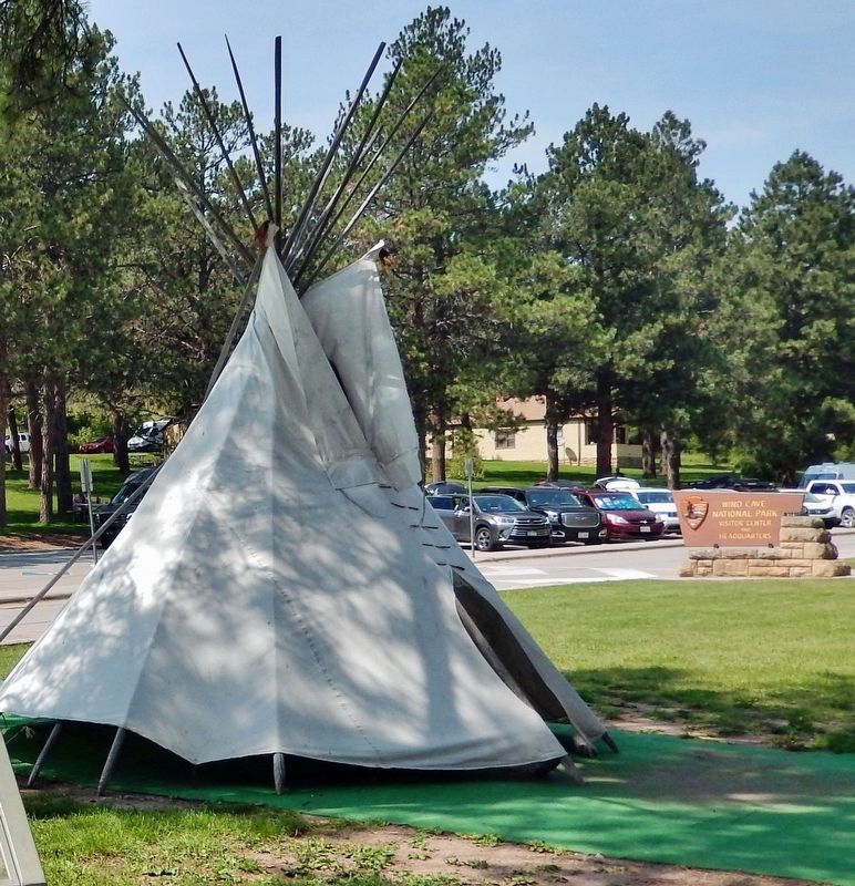
This replica tipi offers a glimpse into a way of life defined by challenge, but filled with freedom. Imagine passing a mid-winter morning inside. Hides line the walls, small fire and friendly company keeping the cold at bay. Or emerging through the doorway on a clear summer night for a last glance at countless stars, stretching silently to all horizons.
Sound appealing? Daunting? Both?
”Our tipi faced east most of the year. We liked the morning sun to waken us. The wind pushing against the back of the lodge forced the smoke out of the tipi... Sometimes we had rocks near the fire and at night we would wrap these hot stones to be placed near our feet to keep them warm.”
—Mrs. Red Warbonnet, Lakota woman, on living in a tipi with her two grandmothers as a young girl
Erected by National Park Service, U.S. Department of the Interior.
Topics.
this page online
Location. 43° 33.378′ N, 103° 28.699′ W. Marker is near Hot Springs, South Dakota, in Custer County. It can be reached from Wind Cave Road one mile south of U.S. 385. The marker and Tipi replica are located along the walkway near the southwest corner of the Wind Cave National Park Visitor Center. Touch for map. Marker is at or near this postal address: 26611 US Highway 385, Hot Springs SD 57747, United States of America. Touch for directions.

Regionally, this marker is in West River and in Greater Rapid City. It is also in the American Black Hills, in the Lewis & Clark Corridor, on the prairies, and on the Northern Plains. Globally, it is in North America, the Western Hemisphere, the Western World, and the Anglosphere. Historically, it finds itself in what was once Rupert’s Land and also the Louisiana Purchase.
Other nearby markers. At least 8 other markers are within 3 miles of this marker, measured as the crow flies: The CCC's Enduring Legacy (here, next to this marker); Stephen Tyng Mather

Photographed by Cosmos Mariner, August 16, 2023
2. Home on the Range Marker
Looking northwest. The Tipi replica & Wind Cave National Park Visitor Center parking in background.
Also see . . . Tipi (Wikipedia). Excerpt:
A tipi, often called a lodge in English, is a conical tent, historically made of animal hides or pelts, and in more recent generations of canvas, stretched on a framework of wooden poles. Historically, the tipi has been used by some Indigenous peoples of the Plains in the Great Plains and Canadian Prairies of North America, notably the seven tribes of the Sioux, as well as among the Iowa people, the Otoe and Pawnee, and among the Blackfeet, Crow, Assiniboines, Arapaho, and Plains Cree. They are also used west of the Rocky Mountains by Indigenous peoples of the Plateau such as the Yakama and the Cayuse. They are still in use in many of these communities, though now primarily for ceremonial purposes rather(Submitted on October 18, 2023, by Cosmos Mariner of Cape Canaveral, Florida.)than daily living.Photographed by Cosmos Mariner, August 16, 20233. Tipi ReplicaA few steps from the marker.
Credits. This page was last revised on October 19, 2023. It was originally submitted on October 18, 2023, by Cosmos Mariner of Cape Canaveral, Florida. This page has been viewed 207 times since then and 15 times this year. Photos: 1, 2, 3. submitted on October 18, 2023, by Cosmos Mariner of Cape Canaveral, Florida.
