Truckee in Nevada County, California — The American West (Pacific Coastal)
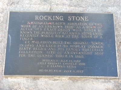
Rocking Stone
C.F. McGlashan built the original tower in 1895 and used it to display Donner Party relics and his famous butterfly collection. Site of an overnight stop for the Olympic Torch in 1960.
Erected 1967 by Chief Truckee Chapter No. 3691, E Clampus Vitus. Dedicated July 15, 1967. Re-dedicated July 4, 1977.
Topics and series. This historical marker is listed in these topic lists: Native Americans • Natural Resources • Notable Places. In addition, it is included in the E Clampus Vitus series list. A significant historical year for this entry is 1895.
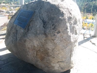
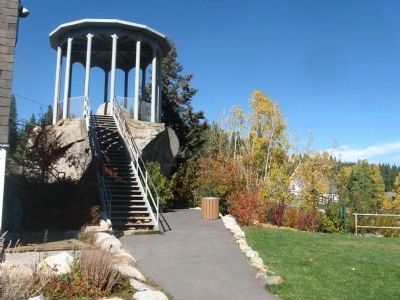
Location. 39° 19.68′ N, 120° 11.28′ W. Marker is in Truckee, California, in Nevada County. Marker is on High Street near Keiser Avenue. Marker is located on the rock at the top of the tower at the Truckee Veterans Hall. Touch for map. Marker is at or near this postal address: 10166 High Street, Truckee CA 96161, United States of America. Touch for directions.
Other nearby markers. At least 8 other markers are within walking distance of this marker. World War I Memorial / Victory Highway Monument (about 300 feet away, measured in a direct line); Old Truckee Jail (about 300 feet away); Theodore Dehone Judah (about 800 feet away); First Transcontinental Railroad - Truckee (about 800 feet away); “The Tin Can” ----------- “Dot’s Place” (approx. 0.2 miles away); Truckee (approx. 0.2 miles away); Truckee’s Old Stone Garage and Site of Town’s First Dwelling (approx. 0.2 miles away); George Schaffer House (approx. 0.2 miles away). Touch for a list and map of all markers in Truckee.
Additional commentary.
1. From the Historic Truckee Walking Tour Brochure
Rocking Stone Tower:
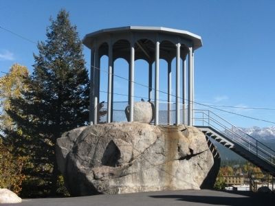
Legend tells us that this rock was used by Native Americans who inhabited this area to keep their fish and dried meat safe from animals and birds. The slightest vibrations of the smaller stone served to frighten the birds away and the height of the larger stone was too high for animals to climb. Although the stone no longer rocks, having been cemented in place, the 17-ton stone is one of 25 known rocking stones in the world.
Charles F. McGlashan, a prominent Truckee citizen from 1872 to 1931 and the man who interviewed the survivors of the Donner Party and wrote The History of the Donner Party, built an enclosed, high-arched windowed tower over this rock in 1893. Inside the tower he kept many of the Donner Party relics and memorabilia, which are now on display at the Donner Memorial State Park Museum. Here he also kept his exquisite collection of butterflies and moths, which can also be viewed at the Donner Museum.
Next to the rock, is the arched Veterans Memorial Building where McGlashan's two-story residence once stood. Constructed in 1903, the residence was similar in design to the tower and when lit up at night, it was given the name, "McGlashan's Crystal Palace.
In 1935 when the landmark was under the care of a caretaker, the mansion burned to the ground. For many years, the land stood vacant until, in 1939, members of the Truckee American Legion Post 439, under the auspices of James McIver Jr., constructed the present building which became a meeting place for most of the town's community activities, including important town meetings, dances, parties, etc.
During World War II civil defense meetings were held in the hall. The nearby Rocking Stone Tower served as an aircraft observation post, as there was fear of an enemy attack on the railroad over the summit.
The building is presently owned by the Truckee-Donner Recreation and Park District and serves as a community center, as well as a meeting place for veterans and other community needs.
— Submitted October 22, 2009, by Syd Whittle of Mesa, Arizona.
Credits. This page was last revised on June 16, 2016. It was originally submitted on October 22, 2009, by Syd Whittle of Mesa, Arizona. This page has been viewed 3,691 times since then and 56 times this year. Photos: 1, 2, 3, 4. submitted on October 22, 2009, by Syd Whittle of Mesa, Arizona.


