McDowell in Highland County, Virginia — The American South (Mid-Atlantic)
The Guns of Cemetery Hill
The Battle of McDowell (May 8, 1862)
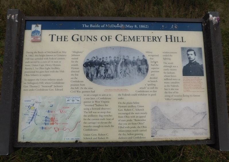
During the Battle of McDowell on May 8, 1862, this height known as Cemetery Hill was crowded with Federal cannon, each served by a crew of 14 men or more. Union Capt. Henry Hyman, Battery I, 1st Ohio Light Artillery, positioned his guns here with the 55th Ohio Infantry in support.
To support the Union infantry attack on Sitlington's Hill, where Confederate Gen. Thomas J. "Stonewall" Jackson's men under Confederate Gen. Edward "Allegheny" Johnson waited for the assault. Hyman directed the fire on the Confederate position from this hill. (At the time Civil War, gunners had to see a target to aim at it; a year later, a Confederate gunner in West Virginia "invented" indirect fire using a forward observer.) The hill was so steep that the artillerists dug trenches for the cannon trails (rear of the carriage) to elevate the muzzles enough to reach the Confederates.
Union Gens, Robert C. Schenck and Robert H. Milroy recognized that Jackson had the superior position and decided to launch a "spoiling attack" to stall the Confederates so that the Federals could withdraw in good order.
On the plains below Hyman's artillery, Union Gen. Robert C. Schenck encouraged the men mostly from Ohio with an appeal of state pride: "Remember that you are from Ohio!" Filled with pride, the Ohio infantrymen nearly carried the day, before growing darkness and Confederate reinforcements ended the fighting.
The result although was a costly victory for Jackson, whose forces suffered twice as many casualties as the Federals, but it also was the first of his string of victories during his famous Valley Campaign.
(Captions):
Union Battery I First Ohio Light Artillery.
Image Courtesy of the Ohio Historical Society
Union Sgt. Oscar D. Ladley, 75th Ohio Infantry, sketched the McDowell Battlefield and Sitlington's Hill from approximately this position. He and his regiment crossed over Cemetery Hill to join the attack. The regiment lost 39 killed, wounded, and missing. Ladley survived the war and left the army in 1865 as a Captain.
Image Courtesy of Wright State University
Sketch of Sitlington's Hill by Sgt. Oscar Ladley 75th Ohio Infantry.
Courtesy of Wright State University
Erected 2022 by Shenandoah Valley Battlefields Foundation.
Topics. This historical marker is listed in this topic list: War, US Civil. A significant historical date for this entry is May 8, 1862.
Location. 38° 19.961′ N, 79° 29.515′ W. Marker is in McDowell, Virginia, in Highland County. Marker is on Bullpasture River Road (Virginia Route 678) 0.2 miles west of Highland Turnpike (U.S. 250), on the right when traveling west. From U.S. Rte. 250, head west on Bullpasture River Road 0.2 miles to an unmarked road on the right which leads uphill to the cemetery and the marker. Touch for map. Marker is at or near this postal address: 199 Bullpasture River Road, Mc Dowell VA 24458, United States of America. Touch for directions.
Other nearby markers. At least 8 other markers are within walking distance of this marker. The Church and Cemetery (approx. 0.2 miles away); McDowell Presbyterian Church (approx. 0.2 miles away); Felix Hull House (approx. 0.2 miles away); McDowell VA - May 8, 1862 (approx. 0.2 miles away); Battle of McDowell (approx. 0.2 miles away); Highway To War (approx. 0.2 miles away); a different marker also named Battle of McDowell (approx. 0.2 miles away); The Mansion House (approx. ¼ mile away). Touch for a list and map of all markers in McDowell.
Related marker. Click here for another marker that is related to this marker.
Credits. This page was last revised on January 20, 2024. It was originally submitted on November 8, 2023, by Bradley Owen of Morgantown, West Virginia. This page has been viewed 68 times since then and 26 times this year. Photos: 1, 2, 3. submitted on November 8, 2023, by Bradley Owen of Morgantown, West Virginia.


