East Las Vegas in San Miguel County, New Mexico — The American Mountains (Southwest)
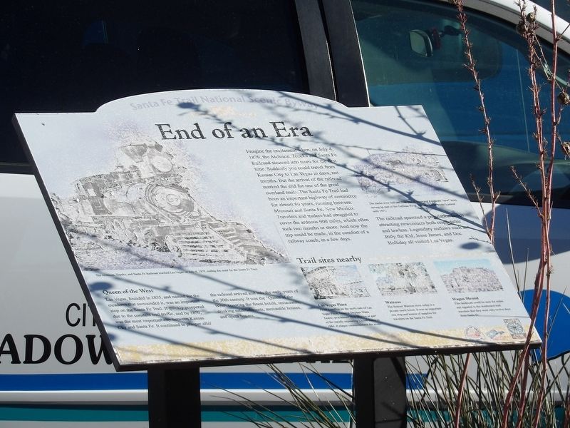
End of an Era
Photographed by Duane and Tracy Marsteller, October 14, 2023
1. End of an Era Marker
The railroad spawned a population boom attracting newcomers both respectable and lawless. Legendary outlaws such as Billy the Kid, Jesse James, and Doc Holliday all visited Las Vegas.
Queen of the West
Las Vegas, founded in 1835, and named for the meadows that surrounded it, was an important stop on the Santa Fe Trail. It quickly prospered due to the constant trail traffic, and by 1850, was the most important city between Kansas City and Santa Fe. It continued to prosper after the railroad arrived and into the early
this page online
Trail Sites Nearby
Las Vegas Plaza From a rooftop on the north side of Las Vegas Plaza, General Stephen Watts Kearny proclaimed New Mexico as part of the rapidly expanding United States in 1846. A plaque commemorates the event.
Watrous The Samuel Watrous store today is a private ranch house. It was an important rest stop and source of supplies for travelers on the Santa Fe Trail.
Wagon Mound This landmark could be seen for miles and signaled to the westbound trail travelers that they were only 12 days from Santa Fe.
[Captions]
• (Left) The Atchison, Topeka & Santa Fe Railroad reached Las Vegas on July 4, 1879, ending the need for the Santa Fe Trail.
• (Right) The tracks were laid one mile east of town and a separate “new” town sprang up east of the Callinas River. The two towns weren't joined until 1971.
Topics. This historical marker is listed in these topic lists: Railroads & Streetcars • Roads & Vehicles. A significant historical date for this entry is July 4, 1879.
Location. 35° 35.618′ N,
Photographed by Duane and Tracy Marsteller, October 14, 2023
2. End of an Era Marker

Regionally, this marker is in Northern New Mexico. It is also in the American Southwest, in the Mountain West, and on the Santa Fe Trail Corridor. Globally, it is in North America, the Rocky Mountains, the Western Hemisphere, the Western World, and the Anglosphere. Historically, it finds itself in what was once New Spain and also the territory of the Ancestral Puebloans.
Other nearby markers. At least 8 other markers are within walking distance of this marker: Atchison, Topeka & Santa Fe Railway Company Depot (within shouting distance of this marker); Gross, Blackwell & Company Commission House (within shouting distance of this marker); Wells Fargo Express Office (about 400 feet away, measured in a direct line); Rawlins House (about 400 feet away); Browne & Manzanares Commission House (about 600 feet away); Rosenthal Brothers General Merchandise Store (about 600 feet away); Clara Waring Bookstore (about 800 feet away); Meadows Hotel (approx. 0.2 miles away). Touch for a list and map of all markers in Las Vegas.
Credits. This page was last revised on November 23, 2023. It was originally submitted on November 22, 2023, by Duane and Tracy Marsteller of Murfreesboro, Tennessee. This page has been viewed 224 times since then and 18 times this year. Photos: 1, 2. submitted on November 22, 2023, by Duane and Tracy Marsteller of Murfreesboro, Tennessee.
