
Downtown Bentonville in Benton County, Arkansas — The American South (West South Central)
Bentonville's Early History
Photographed by Darren Jefferson Clay, November 10, 2023
1. Bentonville's Early History Marker
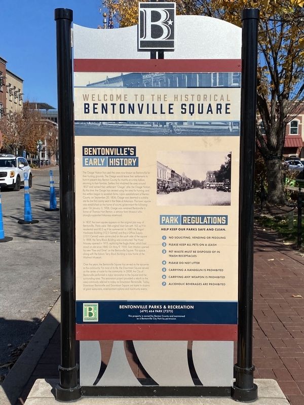
The Osage Nation first used the area now known as Bentonville for their hunting grounds. The Osage would leave their settlements to hunt in present day Benton County for months at a time before returning to their families. Settlers first inhabited the area around 1837 and named their settlement "Osage" after the Osage Nation. By this time, the Osage has ceased using the area for hunting, and the settlers began to establish farms. Upon establishment of Benton County, on September 20, 1836, Osage was deemed a suitable site for the first county seat in the State of Arkansas. The town square was established as the home of county government the following year. On January 3, 1906, Osage was renamed Bentonville in honor of Thomas Hart Benton, a senator from Missouri who strongly supported Arkansas statehood.
In 1837, the town square appears on the original plat map of Bentonville. There were 166 original town lots with 165 sq ft for residential and 82.5 sq ft for commercial. In 1885 the Bogart Hardware Building (112 E Central) and Roy's Office Supply (110 E Central) were constructed on the south side of the square. In 1888,
this page online
Over the years, the Bentonville Square has served as the epicenter to this community. For most of its life, the Downtown Square served as the center of trade for the community. In 2008, the City of Bentonville performed a major renovation to the Square and the surrounding area. This renovation project provided a rebirth to the area commonly referred to today as Downtown Bentonville. Today Downtown Bentonville and Downtown Square are home to dozens of great restaurants, entertainment options and community events.
Topics. This historical marker is listed in these topic lists: Indigenous Peoples and Communities • Industry & Commerce • Parks & Recreational Areas • Settlements & Settlers. A significant historical date for this entry is September 20, 1836.
Location. 36° 22.349′ N, 94° 12.525′ W. Marker is in Bentonville, Arkansas,
Photographed by Darren Jefferson Clay, November 10, 2023
2. Bentonville's Early History Marker

Regionally, this marker is in Northwest Arkansas, on the Ozark Plateau, in the Cherokee Heritage Region, and in Osage Territory. It is also in the American South, specifically in the Upper South, and in the Ozarks. Globally, it is in North America, the Western Hemisphere, the Western World, and the Anglosphere. Historically, it finds itself in what was once the territory of the Mississippian Culture, the Louisiana Purchase, one of the Confederate States of America, and the Antebellum South.
Other nearby markers. At least 8 other markers are within walking distance of this marker: Terry Block (a few steps from this marker); Confederate Memorial (a few steps from this marker); Peoples Bank (within shouting distance of

Photographed by Marc Hayot, May 29, 2026
3. Bentonville's Early History Marker
Another marker is no longer nearby. Walton's 5 & 10 (was a few steps from this marker but has been confirmed missing).
Credits. This page was last revised on May 30, 2026. It was originally submitted on December 15, 2023, by Darren Jefferson Clay of Duluth, Georgia. This page has been viewed 481 times since then and 79 times this year. Photos: 1, 2. submitted on December 27, 2023, by Darren Jefferson Clay of Duluth, Georgia. 3. submitted on May 29, 2026, by Marc Hayot of Siloam Springs, Arkansas. • Devry Becker Jones was the editor who published this page.
