Midlothian in Chesterfield County, Virginia — The American South (Mid-Atlantic)
From Mines to Market
Richmond Coal Basin
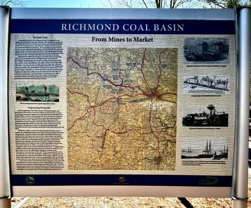
Beginning around 1748, Richmond coal was shipped to the major coastal cities of Colonial America.The market was primarily for smithing and home heating since steam engine development for industry and transportation was still in its infancy and charcoal was the preferred fuel for iron making. The increasing scarcity of wood, however, soon created a bourgeoning market for coal. The early coal mines, or pits, were just north and south of the James River, but the fall line to the east posed a dangerous impediment to shipment of the mined coal to the Tidewater and schooners just east of the city.
Shipment by wagon on unimproved rough roads was less than ideal due to the damage to the soft bituminous coal caused by interminable jostling and the risk of becoming mired in mud with heavy loads. Coal was shipped on the upper James via bateaux that depended on sluices blasted through the rock ridges and enhanced with small wing dams to form manageable channels and mitigate the risks of capsizing. The James River Company was chartered in 1785 (with George Washington as the honorary President) to address this situation and provide a safer water route through the fall lines. In 1789, the two hundred yard long Upper Canal around the falls at Westham and the three mile long Lower Canal terminating in downtown Richmond officially opened and became the first operating canal system with locks in America.
At the beginning of the 19th century, Richmond Basin coal production had become a lucrative industry, and the mine owners increasingly turned to engineers to maximize their productivity and marketability. Notably on the north side of the James, the Tuckahoe canal was built to access tho Tuckahoe and Guyton pits and link to the James River Canal. This link was further improved by the construction of the Tuckahoe and James River Rail Road in 1835. For the decades after 1820, the east-west canal, which became the James River & Kanawha Canal, was improved and ultimately extended east and west along the north side of the James River for 196 miles.
While the colliers of the James improved their route to market, the significant mines to the south could not easily access this canal system. A gravity railroad was built from Black Heath mines northward to the James, but access to the canal system was limited and mines further from the river needed a more economically viable route. In 1807, the Chesterfield mining magnates completed the Manchester Turnpike, the first paved road in Virginia, running thirteen miles from Falling Creek on old Buckingham Road to the port of Manchester. In 1828, not satisfied with seasonal road conditions they chartered the Chesterfield Railroad — Virginia’s first — a thirteen mile gravity and mule powered railway to transport coal from what is now the Midlothian Village area mines to the Manchester docks just east of the falls. This was completed in 1831, and 160 cars were put in operation, significantly reducing the cost of coal loaded on schooners to deliver the major Atlantic coastal cities. This railroad was on of the most profitable in the world until it was replaced by the steam-powered Richmond & Danville in 1850.
Coal exports from the Richmond Basin dropped in the mid 19th century due to the development of the Pennsylvania coal fields and their rail and maritime transportation infrastructure. The Civil War, however, gave Richmond coal production a second wind as coal was needed desperately at the Tredegar Iron Works to fuel production of armament and ironclad ships for the Confederate army and navy.
(captions)
Slaves running bateaux through the James River sluices
James River & Kanawha Canal commerce in Richmond, Virginia
Inaugural trip of Chesterfield Railroad in 1831
Richmond & Danville locomotive James A. Sedon
Schooners loading coal for Federal troops at City Point during Siege of Petersburg, similar to the operations at Warwick and Rocket’s Landing during the past hundred years.
Erected by Chesterfield County and the Virginia Department of Mines, Minerals and Energy.
Topics. This historical marker is listed in these topic lists: Colonial Era • Industry & Commerce • Railroads & Streetcars • War, US Civil. A significant historical year for this entry is 1748.
Location. 37° 29.749′ N, 77° 38.597′ W. Marker is in Midlothian, Virginia, in Chesterfield County. Marker can be reached from North Woolridge Road, 0.1 miles north of Scotter Hills Lane, on the left when traveling north. The marker is located on the west side of Mid-Lothian Mines Park across North Woolridge Road from the main trails. Touch for map. Marker is at or near this postal address: 13301 North Woolridge Road, Midlothian VA 23114, United States of America. Touch for directions.
Other nearby markers. At least 8 other markers are within walking distance of this marker. The Bermuda Hundred Campaign (a few steps from this marker); Headstock (within shouting distance of this marker); Mid-Lothian Mines and Rail Roads (about 400 feet away, measured in a direct line); a different marker also named Mid-Lothian Mines and Rail Roads (approx. 0.3 miles away); a different marker also named Mid-Lothian Mines and Rail Roads (approx. 0.4 miles away); a different marker also named Mid-Lothian Mines and Rail Roads (approx. 0.4 miles away); Midlothian Coal Mines (approx. half a mile away); Salisbury (approx. half a mile away). Touch for a list and map of all markers in Midlothian.
Also see . . . Mid-Lithuanian Mines Park: The Birthplace Of Virgin’s Coal Mining History. (Submitted on December 27, 2023, by Brandon D Cross of Flagler Beach, Florida.)
Credits. This page was last revised on December 27, 2023. It was originally submitted on December 27, 2023, by Brandon D Cross of Flagler Beach, Florida. This page has been viewed 70 times since then and 34 times this year. Photos: 1, 2. submitted on December 27, 2023, by Brandon D Cross of Flagler Beach, Florida. • Bernard Fisher was the editor who published this page.

