Downtown in Fargo in Cass County, North Dakota — The American Midwest (Upper Plains)
Red River Valley
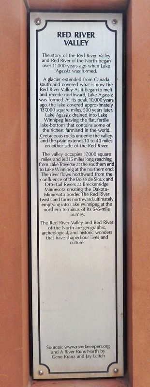
The story of the Red River Valley and Red River of the North began over 11,000 years ago when Lake Agassiz was formed.
A glacier extended from Canada south and covered what is now the Red River Valley. As it began to melt and recede northward, Lake Agassiz was formed. At its peak, 10,000 years ago, the lake covered approximately 137,000 square miles. 500 years later, Lake Agassiz drained into Lake Winnipeg leaving the flat, fertile lake-bottom that contains some of the richest farmland in the world. Cretaceous rocks underlie the valley, and the plain extends 10 to 40 miles on either side of the Red River.
The valley occupies 17,000 square miles and is 315 miles long reaching from Lake Traverse at the southern end to Lake Winnipeg at the northern end. The river flows northward from the confluence of the Boise de Sioux and Ottertail Rivers at Breckenridge Minnesota creating the Dakota-Minnesota border. The Red River twists and turns northward, ultimately emptying into Lake Winnipeg at the northern terminus of its 545-mile journey.
The Red River Valley and Red River of the North are geographic, archeological, and historic wonders that have shaped our lives and culture.
and A River Runs North by
Gene Kranz and Jay Leitch
Topics. This historical marker is listed in these topic lists: Agriculture • Waterways & Vessels.
Location. 46° 52.685′ N, 96° 47.247′ W. Marker is in Fargo, North Dakota, in Cass County. It is in Downtown. Marker is at the intersection of 2nd Avenue North and Broadway North, on the right when traveling west on 2nd Avenue North. The marker is located along the sidewalk near the northeast corner of the intersection. Touch for map. Marker is at or near this postal address: 201 Broadway North, Fargo ND 58102, United States of America. Touch for directions.
Other nearby markers. At least 8 other markers are within walking distance of this marker. Recreation on the Red River (a few steps from this marker); Osco Drug (a few steps from this marker); Black Building & Fargo Theatre (within shouting distance of this marker); Steamboats on the Red River (within shouting distance of this marker); Wildlife in the Red River Valley (within shouting distance of this marker); Plains Art Museum (about 400 feet away, measured in a direct line); NDSU Agriculture (about 400 feet away); Bonanza Farms (about 400 feet away). Touch for a list and map of all markers in Fargo.
Also see . . . Red River Valley (Wikipedia). Excerpt:
The population centers of Moorhead, Minnesota, Fargo and Grand Forks, North Dakota, and Winnipeg, Manitoba developed in the valley as settlement by ethnic Europeans increased in the late nineteenth century. Completion of major railroads, availability of cheap lands, and forceful removal of Indigenous people as well as a subsequent refusal to recognize Indigenous land claims attracted many new settlers. Forming the border between Minnesota and North Dakota when these territories were admitted as states in the United States, this fertile valley has been important to the economies of these states and to Manitoba, Canada.(Submitted on January 28, 2024, by Cosmos Mariner of Cape Canaveral, Florida.)
Credits. This page was last revised on January 28, 2024. It was originally submitted on January 28, 2024, by Cosmos Mariner of Cape Canaveral, Florida. This page has been viewed 62 times since then. Photos: 1, 2, 3. submitted on January 28, 2024, by Cosmos Mariner of Cape Canaveral, Florida.


