Grand View in Owyhee County, Idaho — The American West (Mountains)
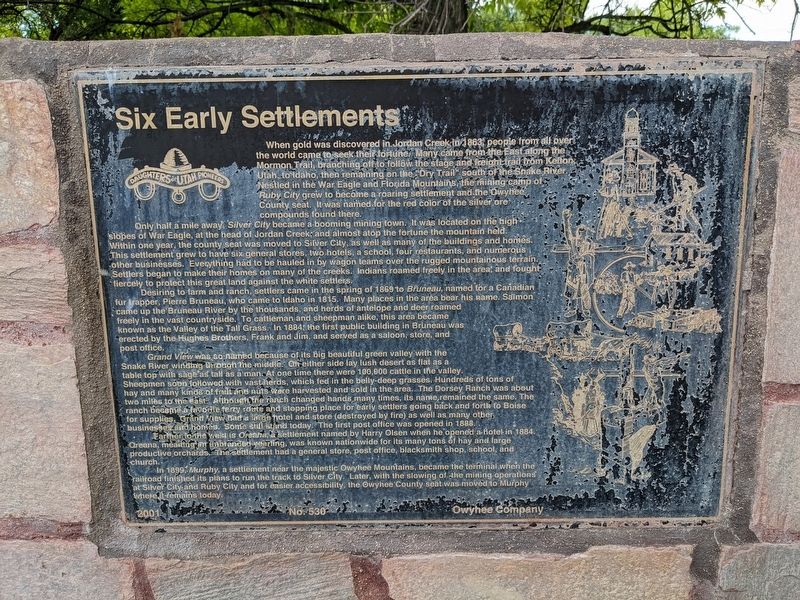
Six Early Settlements
Photographed by Jeremy Snow, July 31, 2023
1. Six Early Settlements Marker
When gold was discovered in Jordan Creek-in 1863 people from all over the world came to seek their fortune. Many came from the East along the Mormon Trail, branching off to follow the stage and freight trail from Kellon, Utah to Idaho, then remaining on the "Dry Trail" south of the Snake River. Nestled in the War Eagle and Florida Mountains, the mining camp of Ruby City grew to become a roaring settlement and the Owyhee County seat. It was named for the red color of the silver ore compounds found there.
Only half a mile away, Silver City became a booming mining town. It was located on the high slopes of War Eagle, at the head of Jordan Creek and almost atop the fortune the mountain held. Within one year, the county seat was moved to Silver City, as well as many of the buildings and homes. This settlement grew to have six general stores, two hotels, a school, four restaurants, and numerous other businesses. Everything had to be hauled in by wagon teams over the rugged mountainous terrain. Settlers began to make their homes on many of the creeks. Indians roamed freely in the area and fought fiercely to protect this
this page online
Desiring to farm and ranch, settlers came in the spring of 1869 to Bruneau, named for a Canadian fur rapper, Pierre Bruneau, who came to Idaho in 1815. Many places in the area bear his name. Salmon came up the Bruneau River by the thousands, and herds of antelope and deer roamed freely in the vast countryside. To cattieman and sheepman alike, this area became known as the Valley of the Tall Grass. In 1884 the first public building in Bruneau was erected by the Hughes Brothers, Frank and Jim, and served as a saloon, store, and post office.
Grand View was so named because of its big beautiful green valley with the Snake River winding through the middle. On either side lay lush desert as flat as a table top with sage ad tall as a man. At one time there were 100,000 cattle in the valley. Sheepmen soon followed with vast herds, which fed in the belly-deep grasses. Hundreds of tons of hay and many kinds of fruit and nuts were harvested and sold in the area. The Dorsey Ranch was about two miles to the east. Although the ranch changed hands many times, its nameremained the same. The ranch became a favorite ferry route and stopping place for early settlers going back and forth to Boise for supplies. Grand View ahd a large hotel and store (destroyed by fire) as well as many other businesses and homes. Some still stand today. The first post office was opened in 1888.
Father to the west is Oreana, a settlement named by Harry Olsen when he opened a hotel in 1884. Oreana, meaning an abandoned yearling, was known nationwide for its many tons of hay and large productive orchards. The settlement had a general store, post office, blacksmith shop, school, and church.
In 1899, Murphy, a settlement near the majestic Owyhee Mountains, became the terminal when the railroad finished its plans to run the track to Silver City. Later, with the slowing of the mining operations at Silver City and Ruby City and for easier accessibility, the Owyhee County seat was moved to Murphy where it remains today.
2001 No. 530 Owyhee Company
Erected 2001 by Daughters of Utah Pioneers. (Marker Number 530.)
Topics and series. This historical marker is listed in these topic lists: Agriculture • Industry & Commerce • Settlements & Settlers. In addition, it is included in the Daughters of Utah Pioneers series list. A significant historical year for this entry is 1863.
Location. 42° 59.304′ N, 116° 5.775′ W. Marker is in Grand View, Idaho, in Owyhee County. It can be reached from Main Street south of Boise Avenue, on the right when traveling south. The marker is in Centennial Park, set back from the street by about 100 feet. Touch for map. Marker is in this post office area: Grand View ID 83624, United States of America. Touch for directions.

Regionally, this marker is on the Snake River Plain. It is also in the American Mountain West. Globally, it is in North America, the Western Hemisphere, the Western World, and the Anglosphere.
Other nearby markers. At least 2 other markers are within 14 miles of this marker, measured as the crow flies: The Utter Disaster (approx. 11.3 miles away); Utter Wagon Train Disaster (approx. 13.2 miles away).
Credits. This page was last revised on February 10, 2024. It was originally submitted on February 6, 2024, by Jeremy Snow of Cedar City, Utah. This page has been viewed 533 times since then and 53 times this year. Photo 1. submitted on February 6, 2024, by Jeremy Snow of Cedar City, Utah. • Andrew Ruppenstein was the editor who published this page.
Editor’s want-list for this marker. photo of marker in its surroundings • Can you help?
