Downtown East in Minneapolis in Hennepin County, Minnesota — The American Midwest (Upper Plains)
Bridges of the St. Anthony Falls Area
| — | Mill Ruins Park | — |
Photographed by McGhiever, August 4, 2023
1. Bridges of the St. Anthony Falls Area Marker
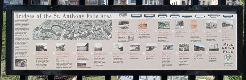
The landscape around the Falls was transformed by many types of construction. Blasting and excavations for bridge supports and rail trackage modified the river banks, rail trestles were built over the canal and tailrace to serve the mills, and a series of platforms suspended sawmills over the river.
Beginning with the first suspension bridge between Nicollet Island and the foot of Hennepin Avenue (1854), more than twenty bridges have been constructed across the river in the stretch between present-day Plymouth and Washington avenues.
A few of the earliest, such a the Christmas Avenue Bridge (1858-59), now Broadway Avenue, lasted only for a short time until they were swept away by floods or log jams.
The succession of bridges built near the Falls displays many historic engineering types.
Open spandrel arch • Closed spandrel deck arch • Howe truss • Pratt truss • Under truss • Through truss • Suspension • Girder or beam
① Hennepin Avenue East Channel
1853-69; 1869-78; 1878-1973- present
Wood beam span supported by pilings; replaced by a stone arch bridge; now steel beam.
② First Hennepin Avenue
1854/55-1876
T.M.
this page online
Wood suspension; first permanent bridge across the Mississippi.
③ St. Paul & Pacific Railroad
1867-1893; 1893-present (with remodeling)
Wood Howe truss; first railroad bridge in Minneapolis. Replaced by beam span.
④ First Upper/Plymouth Avenue
1873-1886
Wood Howe truss.
⑤ Lower/10th Avenue
1874-1943
Iron under-truss bridge replaced an earlier wood footbridge. Bridge linked 6th Ave. S.E. with 10th Ave. S.
⑥ Second Hennepin Avenue
1876-1890
T.M. Griffith, engineer
Stone tower suspension design; replaced 1854 bridge.
⑦ Minneapolis Eastern Railroad Trestle
1879-1962
Elevated trestle along main tailrace canal.
⑧ St. Paul and Northern Pacific Railroad
ca. 1881/1923-present
F.W. Cappelen, engineer
Double-track, deck truss; one of the first steel spans in the Northwest. (Relocated upriver from original location in 1923.) Now a pedestrian bridge.
⑨ St. Paul, Minneapolis & Manitoba Railway "Stone Arch Bridge"
1883-present
C.C. Smith, engineer
St. Cloud granite arch with one steel deck-truss span (added 1963). Refurbished as a pedestrian bridge
Photographed by McGhiever, August 4, 2023
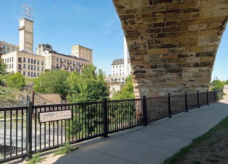
2. Bridges of the St. Anthony Falls Area Marker (left) under the Stone Arch Bridge
⑩ Washington Avenue
1884-1965; 1965-present
Iron truss. Replaced in 1965 with beam span.
1965-present
⑪ Minneapolis Western Railroad Trestle
1885-1936
Over 1st Street (main) waterpower canal. Replaced wood trestle built in 1878 by the Minneapolis and St. Louis Railroad.
⑫ Second Plymouth Avenue
1886-1983
Through-truss iron bridge. Replaced with current concrete box girder bridge in 1983.
⑬ Minneapolis Western Railroad
1887-1952
Iron under-truss.
⑭ Third Hennepin Avenue
1891-1988/89
Two-span steel arch.
⑮ Third Avenue
1918-present
Concrete Steel Engineering Co.
Concrete deck-arch in a reverse S-curve. Spans the Upper St. Anthony Falls Dam. Major renovation in 1980.
⑯ Cedar Avenue (Tenth Avenue)
1929-present
City of Minneapolis, engineer
Concrete rib-deck arch. Widening and new approached in 1976.
⑰ I-35W
1967-present
MnDOT, engineer
Steel and concrete deck-arch truss.
⑱ Fourth Hennepin Avenue
1990-present
HNTB, engineer
Steel suspension; fourth bridge at this location.
Erected by the Minneapolis Park and Recreation Board.
Topics. This historical marker is listed in these topic lists: Bridges & Viaducts • Railroads & Streetcars • Waterways & Vessels. A significant historical year for this entry is 1854.
Location. 44° 58.821′ N, 93° 15.432′ W. Marker is in Minneapolis, Minnesota, in Hennepin County. It is in Downtown East. It is on Portland Avenue, on the right when traveling east. The marker is mounted to the railing where the sidewalk passes under the Stone Arch Bridge. Touch for map. Marker is at or near this postal address: 102 Portland Avenue S, Minneapolis MN 55401, United States of America. Touch for directions.

Regionally, this marker is in the Twin Cities Metropolitan Area. It is also in the American Midwest, in the Corn Belt, and in the Great River Road Region. Globally, it is in North America, the Western Hemisphere, the Western World, and the Anglosphere. Historically, it finds itself in what was once Rupert’s Land, the territory of the Mississippian Culture, and the Louisiana Purchase.
Other nearby markers. At least 8 other markers are within walking distance of this marker: Minneapolis Underground (a few steps from this marker); What is Urban Archaeology? (within shouting distance of this marker); A Changing Landscape (about 300 feet away, measured in a direct line); Mills and Millraces (about 300 feet away); Beneath the Surface (about 300 feet away); A Milling District Timeline (about 400 feet away); The West Side Milling District (about 400 feet away); The West Side Mills (about 400 feet away). Touch for a list and map of all markers in Minneapolis.
Credits. This page was last revised on February 23, 2024. It was originally submitted on February 19, 2024, by McGhiever of Minneapolis, Minnesota. This page has been viewed 395 times since then and 35 times this year. Photos: 1, 2. submitted on February 19, 2024, by McGhiever of Minneapolis, Minnesota. • Andrew Ruppenstein was the editor who published this page.
