Spring Township near Elliottsburg in Perry County, Pennsylvania — The American Northeast (Mid-Atlantic)
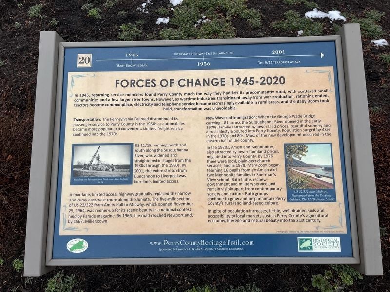
Forces of Change 1945-2020
Perry County Bicentennial
— 1820 - 2020 —
1946: "Baby Boom" began
1956: Interstate highway system launched.
2001: The 9/11 terrorist attack.
In 1945, returning service members found Perry County much the way they had left it: predominantly rural, with scattered small communities and a few larger river towns. However, as wartime industries transitioned away from war production, rationing ended, tractors became commonplace, electricity and telephone service became increasingly available in rural areas, and the Baby Boom took hold, transformation was unavoidable.
Transportation: The Pennsylvania Railroad discontinued its passenger service to Perry County in the 1950s as automobiles became more popular and convenient. Limited freight service continued into the 1970s.
US 11/15, running north and south along the Susquehanna River, was widened and straightened in stages from the 1930s through the 1990s. By 2001, the entire stretch from Duncannon to Liverpool was four-lane, limited access.
A four-lane, limited access highway gradually replaced the narrow and curvy east-west route along the Juniata. The five-mile section of US 22/322 from Amity Hall to Midway, which opened November 25, 1964, was runner-up for its scenic beauty in a national contest held by Parade magazine. In 1966, the road reached Newport and, by 1967, Millerstown.
New Waves of Immigration: When the George Wade Bridge carrying I-81 across the Susquehanna River opened in the early 1970s, families attracted by lower land prices, beautiful scenery and rural lifestyle poured into Perry County. Population surged by 43% in the 1970s and 80s. Most of the new development occurred in the eastern half of the county.
In the 1970s, Amish and Mennonites, also attracted by lower farmland prices, migrated into Perry County. By 1976 there were local, plain-sect church services, and in 1978, Mary Zook began teaching 16 pupils from six Amish and two Mennonite families in Sherman's View school. Both faiths eschew government and military service and remain visibly apart from contemporary society and culture. Both groups continue to grow and maintain Perry County's rural and land-based culture.
In spite of population increases, fertile, well-drained soils and accessibility to local markets sustain Perry County's agricultural economy, lifestyle and natural beauty into the 21st century.
[Captions:]
Building the Susquehanna Trail near New Buffalo, 1951.
US 22/322 near Midway. Photograph from the PA State Archives, RG-12.10, Image 50-89.
Erected 2020 by Historical Society of
Topics and series. This historical marker is listed in these topic lists: Churches & Religion • Immigration • Railroads & Streetcars • Roads & Vehicles. In addition, it is included in the Pennsylvania Railroad (PRR), and the Perry County Heritage Trail in Pennsylvania. series lists. A significant historical date for this entry is November 25, 1964.
Location. 40° 23.086′ N, 77° 17.851′ W. Marker is near Elliottsburg, Pennsylvania, in Perry County. It is in Spring Township. Marker is on Shermans Valley Road (Pennsylvania Route 274) 0.4 miles east of Veterans Way (Pennsylvania Route 74), on the right when traveling east. Touch for map. Marker is at or near this postal address: 2471 Shermans Valley Rd, Elliottsburg PA 17024, United States of America. Touch for directions.
Other nearby markers. At least 8 other markers are within walking distance of this marker. Most Visible Changes 1945-2020 (here, next to this marker); Early Schools, Academies and Religious Institutions (here, next to this marker); Pre-Civil War Transportation Development (here, next to this marker); Building on the Past as We March into the Future (here, next to this marker); Growth of Agriculture, Commerce and Industry Before the Civil War (here, next to this marker); The Perry County Home Front During World War II (here, next to this marker); Post-Civil War Transformation (here, next to this marker); Perry County at Gettysburg: Summer of 1863 (here, next to this marker). Touch for a list and map of all markers in Elliottsburg.
Credits. This page was last revised on March 28, 2024. It was originally submitted on February 29, 2024, by Devry Becker Jones of Washington, District of Columbia. This page has been viewed 39 times since then. Photos: 1, 2. submitted on February 29, 2024, by Devry Becker Jones of Washington, District of Columbia.

