Marker Logo
THE HISTORICAL
MARKER DATABASE
“Bite-Size Bits of Local, National, and Global History”
Columbus Park in Kansas City in Jackson County, Missouri — The American Midwest (Upper Plains)
 

Garrison Field House
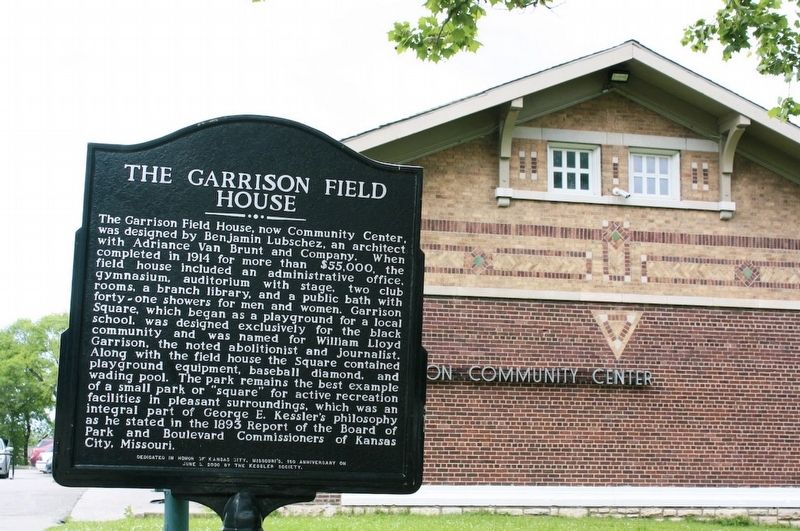
 
 
Garrison Field House Marker image. Click for full size.
1. Garrison Field House Marker
Inscription. The Garrison Field House, now Community Center, was designed by Benjamin Lubschez, an architect with Adriance Van Brunt and Company. When completed in 1914 for more than $55,000, the field house included an administrative office, gymnasium, auditorium with stage, two club rooms, a branch library, and a public bath with forty-one showers for men and women. Garrison Square, which began as a playground for a local school, was designed exclusively for the black community and was named for William Lloyd Garrison, the noted abolitionist and journalist. Along with the field house the Square contained playground equipment, baseball diamond, and wading pool. The park remains the best example of a small park or "square" for active recreation facilities in pleasant surroundings, which was an integral part of George E. Kessler's philosophy as he stated in the 1893 Report of the Board of Park and Boulevard Commissioners of Kansas City, Missouri. Dedicated in honor of Kansas City, Missouri's 150 Anniversary on June 5, 2000 by The Kessler Society.
 
Erected 2000 by The Kessler Society.
 
Topics. This historical marker is listed
Paid Advertisement
Click or scan to see
this page online
in these topic lists: African AmericansArchitectureParks & Recreational Areas. A significant historical date for this entry is June 5, 2000.
 
Location. 39° 6.659′ N, 94° 34.129′ W. Marker is in Kansas City, Missouri, in Jackson County. It is in Columbus Park. It is on East 5th Street west of Forest Avenue, on the right when traveling west. The marker stands southeast of Guinotte Manor. Touch for map. Marker is at or near this postal address: 1124 E 5th St, Kansas City MO 64106, United States of America. Touch for directions.

Regionally, this marker is in the American Midwest, in the Lewis & Clark Corridor, in the Corn Belt, and on the Santa Fe Trail Corridor. Globally, it is in North America, the Western Hemisphere, the Western World, and the Anglosphere. Historically, it finds itself in what was once the territory of the Mississippian Culture, the Louisiana Purchase, and the Antebellum South.

Other nearby markers. At least 8 other markers are within walking distance of this marker: Holy Rosary's Bell Tower Cross (approx. Ό mile away); Moving Settlers West (approx. half a mile away); Moving Indians, Trappers & Traders (approx.
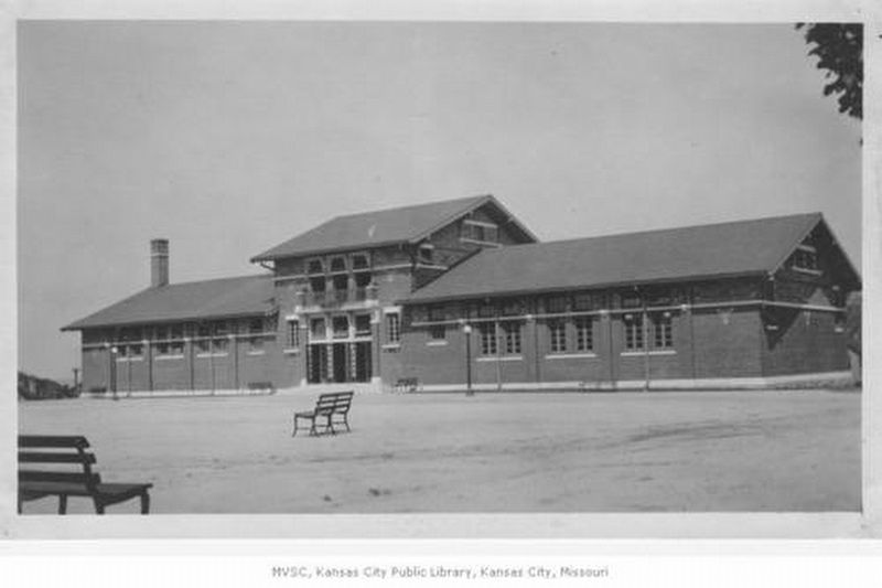
Garrison Field House image. Click for full size.
courtesy Missouri Valley Special Collections, Kansas City Public Library, December 1913
2. Garrison Field House
half a mile away); Moving Hearts & Minds (approx. half a mile away); Moving Water (approx. 0.6 miles away); Kansas City's Old Square (approx. 0.7 miles away); Kansas City's Old Square / Le Vieux Carre de Kansas City (approx. 0.7 miles away); The Old Chouteau Trading Post / Le Vieil Etablissement Commercial Chouteau (approx. 0.7 miles away). Touch for a list and map of all markers in Kansas City.
 
 
Credits. This page was last revised on March 11, 2024. It was originally submitted on March 11, 2024, by Sarah Biegelsen of Kansas City, Missouri. This page has been viewed 414 times since then and 30 times this year. Photos:   1. submitted on March 11, 2024.   2. submitted on March 11, 2024, by Sarah Biegelsen of Kansas City, Missouri. • Devry Becker Jones was the editor who published this page.
 
Editor’s want-list for this marker. A wide shot of the marker in context • Can you help?

m=242814

CeraNet Cloud Computing sponsors the Historical Marker Database.
This website earns income from purchases you make after using our links to Amazon.com. We appreciate your support.
Paid Advertisement
Jul. 25, 2026