Near Oktaha in Muskogee County, Oklahoma — The American South (West South Central)
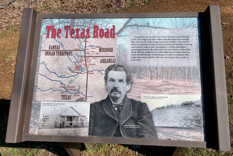
The Texas Road
Honey Springs Battlefield
— Interpretive Trail Three · Confederate Line —
[Captions:]
Right: Ox-drawn wagons on the Texas Road
(Courtesy of Frank Hall Wright Collection)
Left: Joshua Ross store owner
(Courtesy Smithsonian Institution)
Erected 2019 by Friends of Honey Springs Battlefield.
Topics and series. This historical marker is listed in these topic lists: Native Americans • Roads & Vehicles. In addition, it is included in the Honey Springs Battlefield series list.
Location. 35° 33.479′ N, 95° 28.334′ W. Marker is near Oktaha, Oklahoma, in Muskogee County. Marker can be reached from Honey Springs Battlefield Road, 1.9 miles north of East 1020 Road, on the right when traveling north. Touch for map. Marker is in this post office area: Oktaha OK 74450, United States of America. Touch for directions.
Other nearby markers. At least 8 other markers are within walking distance of this marker. 29th Texas Cavalry & 20th Texas Cavalry (within shouting distance of this marker); 5th Texas Partisan Rangers and Lee's Light Battery (within shouting distance of this marker); Breaking the Line, Hand-to-Hand Combat (within shouting distance of this marker); The Confederate Center (within shouting distance of this marker); 1st and 2nd Regiments of Creek Mounted Volunteers (about 300 feet away, measured in a direct line); The Confederate Right (about 300 feet away); 1st and 2nd Regiments of Cherokee Mounted Rifles (about 300 feet away); Primitive Trail to Elk Creek Overlook (about 300 feet away). Touch for a list and map of all markers in Oktaha.
Credits. This page was last revised on March 24, 2024. It was originally submitted on March 24, 2024, by Mark Hilton of Montgomery, Alabama. This page has been viewed 38 times since then. Photos: 1, 2. submitted on March 24, 2024, by Mark Hilton of Montgomery, Alabama.

