
Lewes in Sussex County, Delaware — The American Northeast (Mid-Atlantic)
Saving History
The Bridge at Lewes

Photographed by Pete Skillman, April 6, 2024
1. Saving History Marker
Preservation of the Bridge
The federal government is frequently engaged with projects that affect historic properties. Sometimes these projects result in the deconstruction or altering of properties. In 1966 Congress established the National Historic Preservation Act (NHPA), a program aimed at preserving the historical and cultural foundations of the nation as a living part of community life. Section 106 of the Act is a crucial part of the program which requires federal agencies to consider the effects of projects they carry out, approve, or fund on historic properties. The Section 106 review encourages but does not mandate preservation; however, federal agencies must assume responsibility for the consequences of projects and be publicly accountable for their decisions.
In 2018 the Lewes Swing Bridge (Bridge 3-928R) was determined individually eligible for listing in the National Register of Historic Places (RHP) for its significance and association in Engineering and Transportation as a rare surviving example of a Swing Bridge in Sussex County. The bridge was also determined to be a contributing resource to the eligible
this page online
Historic District, a rail line significant for its contribution to economic growth and development in Delaware and Sussex County from 1869 to 1956. Additionally, the bridge and rail line were instrumental in providing transport of naval ammunition during World War II.
Bridge 3-928R was closed in 2016 after inspections revealed a severely deteriorated and shifting rest pier. The rail line was decommissioned in 2017, and shortly thereafter Delaware Department of Transportation (DelDOT) ultimately decided to remove the bridge from the waterway.
In May 2019, representatives from federal, state, and local agencies came together to discuss potential mitigation options for the bridge's removal. Various relocation options and alternative mitigation alternatives were explored in order to save this significant piece of history. Ultimately, plans were finalized to move the bridge and portions of its operating mechanisms to its current location.
On February 14, 2022, preparations for the relocation of the Lewes Swing Bridge, a structure weighing 223,000 pounds (or 111.5 tons), finally began.
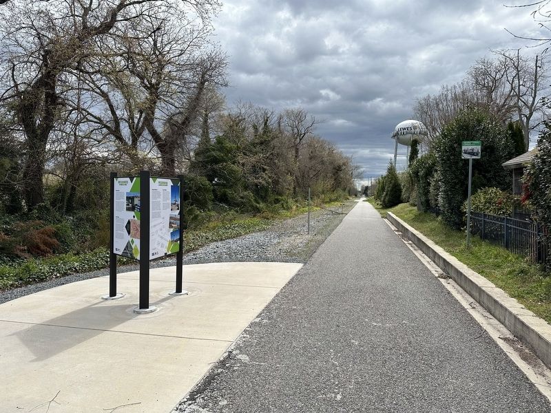
Photographed by Pete Skillman, April 6, 2024
2. Saving History Marker wide view
The memorial site is located in Lewes, at the southeast end of American Legion Road, a little over a quarter mile from its original
Location, where it has been integrated into the recreational Georgetown-to-Lewes Trail. The bridge was preserved through cooperation between the Lewes Junction Railroad & Bridge Association, the City of Lewes, and DelDOT.
[Captions]:
The approximately 70' long bridge on a 900-ton crane, in the process or being placed at its new location. (DelDOT February 16, 2022)
The recreation of the pivot pier at the bridge's new memorial site. (DelDOT February 16, 2022)
Final lowering of bridge onto recreated rest and pivot piers, at the new memorial site. (DelDOT February 16, 2022)
Erected 2022 by Delaware Department of Transportation.
Topics. This historical marker is listed in these topic lists: Bridges & Viaducts • Railroads & Streetcars • Waterways & Vessels. A significant historical year for this entry is 2022.
Location. 38° 46.385′ N, 75° 8.068′ W. Marker is in Lewes, Delaware, in Sussex County. It is on Lewes Georgetown Trail south of Gills Neck Road (Local Road 267), on the right when traveling east. Touch for map. Marker is at or near this postal address: 300 Gills Neck Rd, Lewes DE 19958, United States of America. Touch for directions.

Regionally, this marker is on Delaware’s Beaches. It is also in the American Mid-Atlantic, on the Delmarva Peninsula, and on the Eastern Seaboard. Globally, it is in the North Atlantic Region, North America, the Western Hemisphere, the Western World, and the Anglosphere. Historically, it finds itself in what was once New Netherland, one of the original Thirteen Colonies, and the Antebellum South.
Other nearby markers. At least 8 other markers are within walking distance of this marker: Over Calm Waters (here, next to this marker); Preservation (here, next to this marker); Fallen Heroes Memorial Garden (approx. 0.2 miles away); David Hall House (approx. ¼ mile away); The Fisher-Martin House (approx. ¼ mile away); H.M. Brig DeBraak (approx. ¼ mile away); Lewes (approx. ¼ mile away); Zwaanendael Museum (approx. ¼ mile away). Touch for a list and map of all markers in Lewes.
Credits. This page was last revised on April 8, 2024. It was originally submitted on April 6, 2024, by Pete Skillman of Wilmington, Delaware. This page has been viewed 166 times since then and 10 times this year. Photos: 1, 2. submitted on April 6, 2024, by Pete Skillman of Wilmington, Delaware. • Devry Becker Jones was the editor who published this page.
