Near Virgelle in Fergus County, Montana — The American West (Mountains)
Welcome to Prairie White Cliffs Ranch
Enduring Scenes of Visionary Enchantment

Photographed by Barry Swackhamer, August 18, 2022
1. Welcome to Prairie White Cliffs Ranch Marker
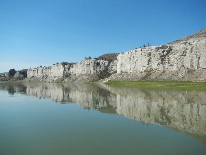
For the last four miles, you have been floating past a family farm and ranch whose riverfront lands are world-renowned for still looking more as they did when Lewis and Clark journeyed here than virtually any others in America. Much the same can be said for the vast stretches of prairie above the Missouri here - along with the famed White Cliffs, they still feature the same naturally sustained productivity that has defined their essence for generations.
The White Cliffs have endured as people have come and gone over thelast 200 years. Most settles merely passed through on steamboats bound for more hospitable areas of present-day Montana. Only a few stayed in this uncommonly dry and challenging county - and very few of them have stayed for long. The stone house whose remains still stand nearby was built in the late 1800s of hand-cut, native stone by Jack Munro. A stone mason by trade, Munro made his living by periodically rounding up wild horses and selling them in Miles City, Montana. Soon after, in 1900, a New Yorker named Gage Clark came to settle here with is wife and child. Gage built a five-room, two-story frame
this page online
It was 1981 when the present-day owner's family bought the farm and ranch. On the predominantly flat land above the river, the family has done some drylands farming-growing wheat and barley-but most of the lands have been used for grazing by sheep and cattle. With the help of a program called Undaunted Stewardship, the landowner preserves riverfront historic sites and manages the property so that livestock grazing sustains natural vegetation and enhances wildlife habitat.
(sidebar on the left)
"The hills and river Clifts which we passed today exhibit a most romantic appearance...we see the remains or ruins of eligant buildings;...As we passed on it seemed as if those seens of visionary inchantment would never have and end;... so perfect indeed are those walls that I should have thought that nature had attempted here to rival the human are of masonry..."(sic) Meriwether Lewis, May 31, 1805
Erected by Undaunted Stewardship.
Topics and series. This historical marker is listed in these topic lists: Exploration • Natural Features • Settlements & Settlers.

Photographed by Barry Swackhamer, August 18, 2022
2. Welcome to Prairie White Cliffs Ranch Marker
Location. 47° 53.835′ N, 110° 3.801′ W. Marker is near Virgelle, Montana, in Fergus County. It can be reached from Unreachable by road. Access is by float-trip from Coal Bank Landing. The marker is on the left bank of the Missouri River, about 17 river miles downstream from Coal Bank Landing. Touch for map. Marker is in this post office area: Loma MT 59460, United States of America. Touch for directions.

Regionally, this marker is in andspecifically entral Montana in Russell Country. It is also in the American Mountain West and in the Lewis & Clark Corridor. Globally, it is in North America, the Western Hemisphere, the Western World, and the Anglosphere. Historically, it finds itself in what was once Rupert’s Land and also the Louisiana Purchase.
Other nearby markers. At least 3 other markers are within 13 miles of this marker, measured as the crow flies: Virgelle State Bank (approx. 11.8 miles away); Virgelle Mercantile (approx. 11.9 miles away); Coal Banks Landing (approx. 12.3 miles away).

Photographed by Barry Swackhamer, August 18, 2022
3. Ruins of the Jack Munro Homestead

Photographed by Barry Swackhamer, August 18, 2022
4. Ruins of the Gage Clark Homstead
Photographed by Barry Swackhamer, August 18, 2022
5. The White Cliffs

Photographed by Barry Swackhamer, August 18, 2022
6. The White Cliffs

Photographed by Barry Swackhamer, August 18, 2022
7. Hole-in-the-Wall
Photographed by Barry Swackhamer, August 18, 2022
8. Citadel Rock
Credits. This page was last revised on November 16, 2024. It was originally submitted on May 9, 2024, by Barry Swackhamer of Brentwood, California. This page has been viewed 245 times since then and 27 times this year. Photos: 1, 2, 3, 4, 5, 6, 7, 8. submitted on May 9, 2024, by Barry Swackhamer of Brentwood, California.
