THE HISTORICAL
MARKER DATABASE
“Bite-Size Bits of Local, National, and Global History”
Carlisle in Cumbria, England, United Kingdom — Northwestern Europe (the British Isles)
 

The Citadel or Court Houses


The Citadel or Court Houses Marker image. Click for full size.
Photographed by Ray Gurganus, April 11, 2024
1. The Citadel or Court Houses Marker
Inscription. The towers were erected in 1810 from original designs by Thomas Telford completed by Sir Robert Smirke. They replace similar structures built on the order of Henry VIII in 1542 by his military engineer, Stefan Von Haschenperg to guard the southern end of the city, and to serve as an additional defence to the castle. The lower part of the old eastern bastion was preserved, but the western bastion was removed and the new tower sited further west. The original citadel towers were joined by a curtain wall and the entrance to the city from the south was by a gate in the city wall to the west of the westernmost tower. The original town defences probably begun about 1130 were gradually extended to enclose a triangular area of approximately 37 acres between the castle and the site of the citadel towers. Much of the medieval wall on the west remains, but the east wall which ran along the middle of Lowther Street as far as east tower street was removed about 1811.
 
Topics. This historical marker is listed in these topic lists: Forts and Castles • Law Enforcement. A significant historical year for this entry is 1810.
 
Location. 54° 53.513′ N, 2° 56′ W.
Paid Advertisement
Click or scan to see
this page online
Marker is in Carlisle, England, in Cumbria. It can be reached from English Street. Located along the sidewalk inside the tower. Touch for map. Marker is at or near this postal address: 11 English St, Carlisle, England CA3 8ND, United Kingdom. Touch for directions.

Regionally, this marker is in North West England. It is also in British Border Reivers Country. Globally, it is on the Atlantic Ocean, in the North Atlantic Region, in Europe, in Atlantic Europe, on one of the British Isles, in the Western World, and in the Anglosphere. Historically, it finds itself in what was once the Roman Empire.

Other nearby markers. At least 6 other markers are within 10 kilometers of this marker, measured as the crow flies: Changing Scenes of Carlisle (within shouting distance of this marker); Cathedral Church (approx. 0.4 kilometers away); Cloister (approx. 0.4 kilometers away); Fratry (approx. half a kilometer away); The Captain's Tower (approx. 0.8 kilometers away); King Edward I Statue (approx. 8.6 kilometers away).
 
Citadel Tower image. Click for full size.
Photographed by Ray Gurganus, April 11, 2024
2. Citadel Tower
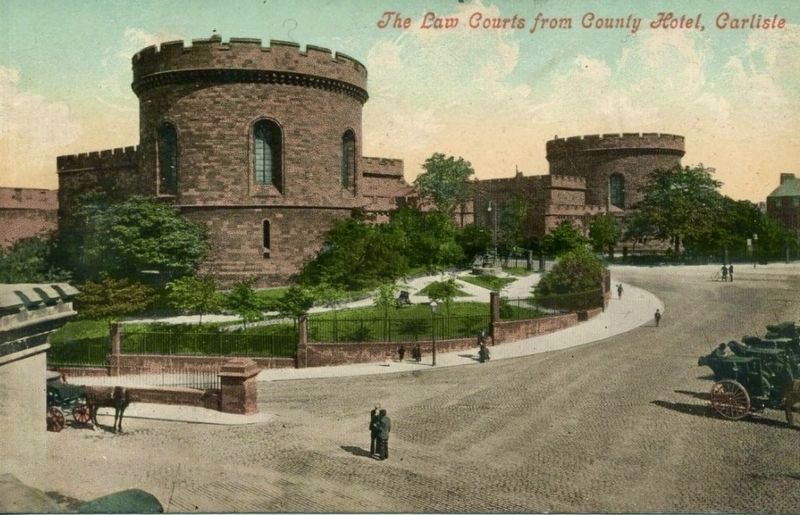
The Law Courts image. Click for full size.
circa 1910
3. The Law Courts
 
 
Credits. This page was last revised on May 16, 2024. It was originally submitted on May 14, 2024, by Ray Gurganus of Washington, District of Columbia. This page has been viewed 163 times since then and 16 times this year. Photos:   1, 2. submitted on May 14, 2024, by Ray Gurganus of Washington, District of Columbia.   3. submitted on May 16, 2024. • Andrew Ruppenstein was the editor who published this page.

m=246681

CeraNet Cloud Computing sponsors the Historical Marker Database.
This website earns income from purchases you make after using our links to Amazon.com. We appreciate your support.
Paid Advertisement
Sep. 29, 2026
