Webster Station in Dayton in Montgomery County, Ohio — The American Midwest (Great Lakes)
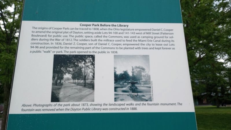
Cooper Park Before the Library
| — | Patterson Boulevard Canal Parkway | — |
Photographed by Craig Doda, May 4, 2024
1. Cooper Park Before the Library Marker
The origins of Cooper Park can be traced to 1808, when the Ohio legislature empowered Daniel C. Cooper to amend the original plat of Dayton, setting aside Lots 94-100 and 141-143 west of Mill Street (Patterson Boulevard) for public use. The public space, called the Commons, was used as camping ground for soldiers during the War of 1812. The soldiers built the millrace used to feed the Miami Erie Canal during its construction. In 1836, Daniel Z. Cooper, son of Daniel C. Cooper, empowered the city to lease out Lots 94-96 and provided for the remaining part of the Commons to be planted with trees and kept forever as a public "walk" or park. The park opened to the public in 1838.
[Caption:]
Above: Photographs of the park about 1873, showing the landscaped walks and the fountain monument. The fountain was removed when the Dayton Public Library was constructed in 1888.
Erected 2017.
Topics and series. This historical marker is listed in this topic list: Parks & Recreational Areas. In addition, it is included in the The Miami & Erie Canal series list. A significant historical year for this entry is 1808.
Location. 39° 45.701′ N, 84° 11.225′ W.
this page online

Regionally, this marker is in Ohio’s Miami Valley. It is also in the American Midwest and in the Corn Belt. Globally, it is in North America, the Western Hemisphere, the Western World, and the Anglosphere. Historically, it finds itself in what was once the Haudenosaunee (Iroquois) Confederacy, the territory of the Mississippian Culture, and the Northwest Territory.
Other nearby markers. At least 8 other markers are within walking distance of this marker: William McKinley Statue (here, next to this marker); The "New" Library (here, next to this marker); The Dayton Metro Library (here, next to this marker); The Library and the Flood (here, next to this marker); Inside the Library (here, next to this marker); Ambrose Winters Fountain (here, next to this marker); The Library in a Changing City

Photographed by Craig Doda, May 4, 2024
2. Cooper Park Before the Library Marker
Credits. This page was last revised on May 20, 2024. It was originally submitted on May 17, 2024, by Craig Doda of Napoleon, Ohio. This page has been viewed 368 times since then and 31 times this year. Photos: 1, 2. submitted on May 17, 2024, by Craig Doda of Napoleon, Ohio. • Devry Becker Jones was the editor who published this page.
