Franklin Township in Waverly in Ross County, Ohio — The American Midwest (Great Lakes)
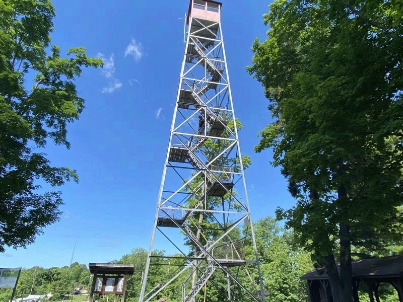
Scioto Trail Fire Tower
| — | Let's Get Historic | — |

Photographed by Cajun Scrambler, May 28, 2024
1. Scioto Trail Fire Tower Marker
Built in 1925, fire wardens and foresters used the 60-foot-tall Scioto Trail Fire Tower to spot blazes on Ohio lands. Ohio fire towers were staffed by lookouts and equipped with binoculars, maps, a radio, telephone, and an alidade - a device used to pinpoint a wildfire location. At the time the Scioto Trail Fire Tower was built, it had an average visibility of 10 miles in all directions.
Though the last tower was closed in 1978, this tower still stands as a proud symbol of forest conservation and a monument to the people who worked to preserve our natural resources. From the top of the tower, the Scioto Trail Fire Tower provides a magnificent 360-degree view of the surrounding forests and hills.
Erected by Ohio Department of Natural Resources. (Marker Number 43.)
Topics. This historical marker is listed in these topic lists: Horticulture & Forestry • Notable Buildings • Parks & Recreational Areas. A significant historical year for this entry is 1925.
Location. 39° 12.972′ N, 82° 58.534′ W. Marker is in Waverly, Ohio, in Ross County. It is in Franklin Township. It is on Stoney Creek Road (Ohio Route
this page online

Regionally, this marker is in the Scioto Valley and in Southern Ohio Hill Country. It is also in the American Midwest, in the Corn Belt, and in Northern Appalachia. Globally, it is in North America, the Western Hemisphere, the Western World, and the Anglosphere. Historically, it finds itself in what was once the Viceroyalty of New France, the Haudenosaunee (Iroquois) Confederacy, the territory of the Mississippian Culture, and the Northwest Territory.
Other nearby markers. At least 8 other markers are within 4 miles of this marker, measured as the crow flies: Ohio Forest Management Through the Years (a few steps from this marker); The American Chestnut (within shouting distance of this marker); Ross County Underground Railroad / The Underground Railroad (approx. 0.4 miles away); Scioto Trail (approx. 1½ miles away); The Lending Tackle Box Tackle Box Program (approx. 1½ miles away); Historic Log Church Replica (approx. 1½ miles away); William Hewitt Monument

Photographed by Cajun Scrambler, May 28, 2024
2. Scioto Trail Fire Tower Marker
More about this marker. Located in the Scioto Trails State Park
Photographed by Cajun Scrambler, May 28, 2024
3. Scioto Trail Fire Tower Marker
Credits. This page was last revised on November 13, 2024. It was originally submitted on May 29, 2024, by Cajun Scrambler of Assumption, Louisiana. This page has been viewed 527 times since then and 56 times this year. Photos: 1, 2, 3. submitted on May 29, 2024, by Cajun Scrambler of Assumption, Louisiana.
