
Ghent Square in Norfolk, Virginia — The American South (Mid-Atlantic)
The Norfolk 17
Photographed by Scott Rollins, February 25, 2012
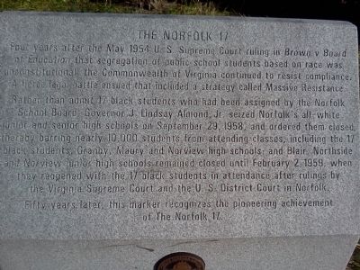
1. The Norfolk 17 Marker
Top of marker
Rather than admit 17 black students who had been assigned by the Norfolk School Board, Governor J. Lindsay Almond, Jr. seized Norfolk's all-white junior and senior high schools on September 29, 1958, and ordered them closed, thereby barring nearly 10,000 students from attending classes, including the 17 black students. Granby, Maury and Norview high schools; and Blair, Northside and Norview junior high schools remained closed until February 2, 1959, when they reopened with the 17 black students in attendance after rulings by the Virginia Supreme Court and the U. S. District Court in Norfolk.
Fifty years later, this marker recognizes the pioneering achievement of The Norfolk 17.
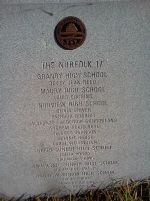
The Norfolk 17
Granby High School
Betty Jean Reed
Maury High School
Louis Cousins
Norview High School
Olivia Driver
Patricia
this page online
Alveraze Frederick Gonsouland
Andrew Heidelberg
Delores Johnson
Johnnie Rouse
Carol Wellington
Blair Junior High School
Lolita Portis
Reginald Young
Northisde Junior High School
Geraldine Talley
Norview Junior High School
Levera Forbes
Edward Jordan
James Turner Jr
Patricia Turner
Claudia Wellington
Erected 2009.
Topics. This historical marker is listed in these topic lists: African Americans • Civil Rights • Education. A significant historical date for this entry is February 2, 1959.
Location. 36° 51.892′ N, 76° 17.459′ W. Marker is in Norfolk, Virginia. It is in Ghent Square. It is on Shirley Avenue 0.1 miles west of Botetourt Gardens, on the right when traveling west. Touch for map. Marker is at or near this postal address: 322 Shirley Avenue, Norfolk VA 23517, United States of America. Touch for directions.

Regionally, this marker is in Virginia’s Hampton Roads, specifically in Coastal Virginia, and in the Hampton Roads Metropolitan Area. It is also in the American South, specifically in the Upper South, in the Tidewater, and on the Eastern Seaboard. Globally, it is in the North Atlantic
Photographed by Scott Rollins, February 25, 2012
2. The Norfolk 17 Marker
Front face of marker
Other nearby markers. At least 8 other markers are within walking distance of this marker: A different marker also named The Norfolk 17 (approx. 0.4 miles away); Blair Junior High School (approx. 0.4 miles away); West Point Monument at Elmwood Cemetery (approx. 0.4 miles away); West Point Monument (approx. 0.4 miles away); West Point Cemetery (approx. 0.4 miles away); Fort Tar (approx. half a mile away); a different marker also named West Point Cemetery (approx. half a mile away); The Yellow Fever Epidemic of 1855 (approx. 0.6 miles away). Touch for a list and map of all markers in Norfolk.
Another marker is no longer nearby. Pauline Adams (was approx. half a mile away but has been confirmed missing).
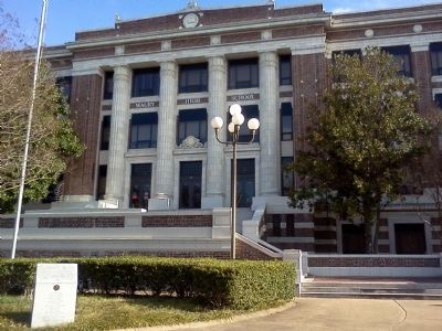
More about this marker. There are six of these markers, which are identical, located in front of each of the schools listed on the
Photographed by Scott Rollins, February 25, 2012
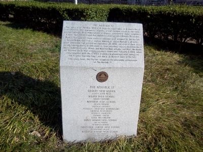
3. The Norfolk 17 Marker
Photographed by Scott Rollins, February 25, 2012
4. Maury High School & The Norfolk 17 Marker
Credits. This page was last revised on June 1, 2024. It was originally submitted on March 13, 2012, by Kristin Rollins of Portsmouth, Virginia. This page has been viewed 2,158 times since then and 47 times this year. Last updated on May 31, 2024, by Brandon D Cross of Flagler Beach, Florida. Photos: 1, 2, 3, 4. submitted on March 13, 2012, by Kristin Rollins of Portsmouth, Virginia. • J. Makali Bruton was the editor who published this page.
