Old Greenwich in Western Region, Connecticut — The American Northeast (New England)
Old Greenwich
Photographed by Tom Fuchs, May 25, 2007
1. Old Greenwich Marker
Inscription.
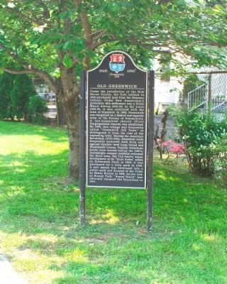
Under the jurisdiction of the New Haven Colony, the first settlers in 1640 purchased land from the Siwanoy Indians. Under New Amsterdam’s protection, this settlement was a dutch manor during 1642–56. In the years 1656–65, it was combined with the town of Stamford. In 1665, Greenwich was recognized as a distinct and separate town in the Colony of Connecticut. A tax-supported church (First Congregational Church) was established. By 1690, this village was frequently called “Greenwich Old Town” to distinguish it from the rest of the expanding town. During the American Revolution (1775–1782), wheelboat raids frequently occurred, both from and against Loyalist held Long Island and Westchester County. Popular waterfront hotels were started during the 1860’s; increasingly, summer residents enlivened the shore area. The Tod family began development of its “Innis Arden” estate on Greenwich Point in 1889; it was purchased for a town park in 1945. A salt marsh was developed into a public park and donated to the town by Edwin Binney in 1928, now known as Binney Park. “Sound Beach” was officially renamed Old Greenwich in 1931.
Location. 41° 1.793′ N, 73° 34.036′ W. Marker is in Greenwich in Western Region, Connecticut. It is in Old Greenwich. It is on Sound Beach Avenue, on the left when traveling north. Touch for map. Marker is at or near this postal address: 276 Sound Beach Ave, Old Greenwich CT 06870, United States of America. Touch for directions.
Regionally, this marker is on the Connecticut Shoreline and in Greater Bridgeport. It is also in the American Northeast, in New England, and on the Eastern Seaboard. Globally, it is in the North Atlantic Region, North America, the Western Hemisphere, the Western World, and the Anglosphere. Historically, it finds itself in what was once Fairfield County and also one of the original Thirteen Colonies.
Credits. This page was last revised on May 19, 2026. It was originally submitted on September 13, 2007, by Tom Fuchs of Greenbelt, Maryland. This page has been viewed 2,850 times since then and 87 times this year. Photos:1, 2. submitted on September 13, 2007, by Tom Fuchs of Greenbelt, Maryland. • J. J. Prats was the editor who published this page.