Near Gloucester in Gloucester County, Virginia — The American South (Mid-Atlantic)
Rosewell and Werowocomoco
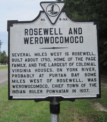
Photographed by Kevin W., July 21, 2010
1. Rosewell and Werowocomoco Marker
Note two digits on the dedication year are transposed, erroneously implying the marker was erected in 1298.
Erected 1928 by Conservation & Development Commission. (Marker Number 8-NA.)
Topics and series. This historical marker is listed in these topic lists: Indigenous Peoples and Communities • Notable Buildings. In addition, it is included in the Virginia Department of Historic Resources (DHR) series list. A significant historical year for this entry is 1750.
Location. Marker has been reported missing. It was located near 37° 20.708′ N, 76° 31.351′ W. Marker was near Gloucester, Virginia, in Gloucester County. It was on George Washington Memorial Highway (U.S. 17) south of Hickory Fork Road, on the right when traveling north. Touch for map. Marker was at or near this postal address: 5113 George Washington Memorial Hwy, White Marsh VA 23183, United States of America. Touch for directions.

Regionally, this marker was on the Middle Peninsula and in the Hampton Roads
this page online
Other nearby markers. At least 8 other markers are within walking distance of this location: Robert Russa Moton (here, next to this marker); United Negro College Fund (a few steps from this marker); Fairfield (approx. ¼ mile away); Rosewell (approx. ¼ mile away); Warner Hall (approx. 0.8 miles away); Abingdon Church (approx. 0.9 miles away); These Page Family Tombs (approx. 0.9 miles away); The Page Family (approx. 0.9 miles away). Touch for a list and map of all markers in Gloucester.
Other markers no longer nearby. Dr. Walter Reed’s Birthplace (was here, next to this marker but has been confirmed missing); Governor John Page (was
Photographed by Laura Troy, October 13, 2007
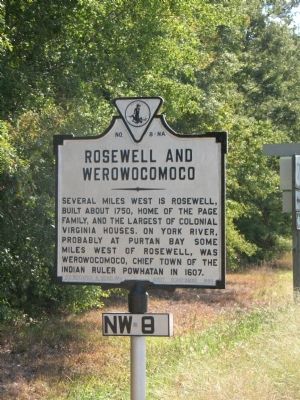
2. Rosewell and Werowocomoco Marker
More about this marker. This marker is numbered NA-8 on its face and has a marker number correction on its pole specifying NW-8 (shown on Photo 2). Virginia Department of Historic Resources online database numbers this marker NA-8. The original 1928 Key to Inscriptions on Virginia Historical Markers published by the Virginia Conservation and Development Commission—and all subsequent editions—number this marker NW-8, as do Margaret Peter’s 1985 Guidebook to Virginia’s Historical Markers and John Salmon’s 1994 edition. But Scott Arnolds’s 2007 edition numbers it NA-8.
Also zoom in and check out the year it was cast that is shown on the marker: a typo reading “1298”.
Regarding Rosewell and Werowocomoco. Rosewell—The ruins of one of the finest mansions built in the colonies sit on the banks of the York River in Gloucester County, Virginia. Here, you may see the brickwork and grace of form and scale which have inspired poets and architects since Thomas Jefferson. Begun in 1725, Rosewell was home to the Page family for more than 100 years. John Page, grandson of the builder,
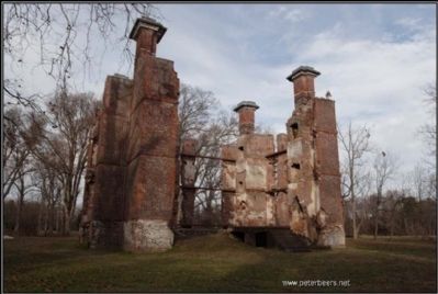
Photographed by Peter Beers, December 28, 2005
3. Ruins of Rosewell Plantation
Picture from www.peterbeers.net
Though slightly changed by a later owner and ravaged by time and economic hardships, Rosewell was still regarded as a place of grandeur and importance. Through the lean years following the War Between The States, parties and dances continued in the Great Hall. Finally, in 1916, a tragic fire swept the mansion leaving a magnificent shell which is testament to 18th century craftsmanship and dreams.
What remains are the four chimneys, the east wall with its regal compasshead window complete with carved keystone, the wine cellar, and enough of the walls that one may sense the proportion and scale of this unique structure. The fourth and last family to own Rosewell donated the ruins site to the Gloucester Historical Society in 1979. Since 1995, the Rosewell Foundation has taken on the mission of preserving, studying, and presenting this historic ruin.
From www.rosewell.org
Werowocomoco—Werowocomoco was a village which served as the political center of the Powhatan Confederacy, a grouping of 30 Native American tribes, speaking an Algonquian language which was formed in the coastal plain area they called Tsenacommacah in what is now the Commonwealth of Virginia by the late 16th century.
Werowocomoco was located near the north bank of the York River in what is now Gloucester County. Across the York River and the narrow Virginia Peninsula, many of the first English-Native encounters occurred during the establishment of the Colony of Virginia and its principal settlement at Jamestown on the James River beginning on June 14, 1607.
from wikpedia.org
Credits. This page was last revised on June 17, 2024. It was originally submitted on October 14, 2007, by Laura Troy of Burke, Virginia. This page has been viewed 2,081 times since then and 41 times this year. Last updated on June 15, 2024, by Jessica Hulstine of Mathews, Virginia. Photos: 1. submitted on July 27, 2010, by Kevin W. of Stafford, Virginia. 2, 3. submitted on October 14, 2007, by Laura Troy of Burke, Virginia. • Devry Becker Jones was the editor who published this page.
