
Bennett in Stikine Region, British Columbia — Canada’s West Coast (North America)
Welcome
⎯⎯⎯
Bienvenue
Photographed by Sandra Hughes Tidwell
1. Welcome / Bienvenue Marker

Klondike Gold Rush International Park
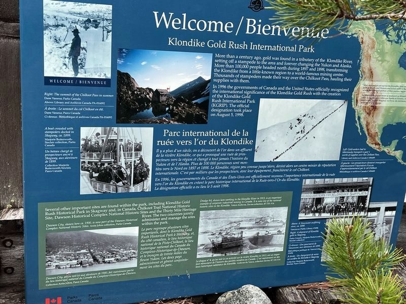
More than a century ago, gold was found in a tributary of the Klondike River, setting off a stampede to the area and forever changing the Yukon and Alaska. More than 100,000 people headed north during 1897 and 1898, transforming the Klondike from a little-known region to a world-famous mining centre. Thousands of stampedes made their way over the Chilkoot Pass, hauling their supplies with them.
In 1996 the governments of Canada and the United States officially recognized the international significance of the Klondike Gold Rush with the creation of the Klondike Gold Rush International Park (KGRIP). The official designation took place on August 5, 1998.
Il y a plus d'un siècle, on a découvert de l'or dans un affluent de la rivière Klondike, ce qui a provoqué une ruée de prospecteurs vers la région et changé à tout jamais l'histoire du Yukon et de l'Aska. Plus de 100 000 personnes sont montées vers le Nord en 1897 et 1898. Le Klondike, région peu connue josqu'alors, devint alors un centre minier de réputation internationale. C'est par millier que les prospecteurs, avec leur équipment, franchirent le col Chilkoot.
En 1996, les gouvernements du Canada et des États-Unis ont officiellement reconnu l'importance internationale de la ruée La désignation officielle a eu lieu le 5 août 1998.
Several
this page online
Erected by Parks Canada.
Topics. This historical marker is listed in these topic lists: Industry & Commerce • Natural Resources • Parks & Recreational Areas. A significant historical year for this entry is 1898.
Location. 59° 50.727′ N, 134° 59.883′ W. Marker is in Bennett, British Columbia, in Stikine Region. It can be reached from Chilkoot Trail (British Columbia Route 98) 19.2 kilometers north of Dyea Road, on the right when traveling north. The marker stands in the Chilkoot Trail National Historic Site. Touch for map. Marker is in this post office area: Bennett BC V0W 1A0, Canada. Touch for directions.

Regionally, this marker is in Northern BC. Globally, it is in North America, on the Ring of Fire, in the Pacific Rim, in the Western Hemisphere, in the Western World, and in the Anglosphere. Historically, it finds itself in what was once a British colony.
Other nearby markers. At least 7 other markers are within 16 kilometers of this marker, measured as the crow flies: Chilkoot Trail National Historic Site / Lieu historique national de la Piste-Chilkoot (here, next to this marker); Names on the land / Noms de la terre (here, next to this marker); A Precious Place / Un endroit préciux (here, next to this marker); St. Andrew's Church / Église St. Andrew's (within shouting distance of this marker); End of Trail / Fin de la piste (within shouting distance of this marker); Fraser (approx. 14.4 kilometers away); a different marker also named Fraser (approx. 14.7 kilometers away).
Credits. This page was last revised on July 27, 2026. It was originally submitted on June 17, 2024, by Sandra Hughes Tidwell of Killen, Alabama, USA. This page has been viewed 135 times since then and 16 times this year. Photo 1. submitted on June 17, 2024, by Sandra Hughes Tidwell of Killen, Alabama, USA. • Devry Becker Jones was the editor who published this page.
Editor’s want-list for this marker. A wide shot of the marker in context • Can you help?
