
Bennett in Stikine Region, British Columbia — Canada’s West Coast (North America)
End of Trail
Chilkoot Trail National Historic Site
⎯⎯⎯
Fin de la piste
Lieu historique national de la Piste-Chilkoot
| — | Parks Canada | — |
Photographed by Sandra Hughes Tidwell
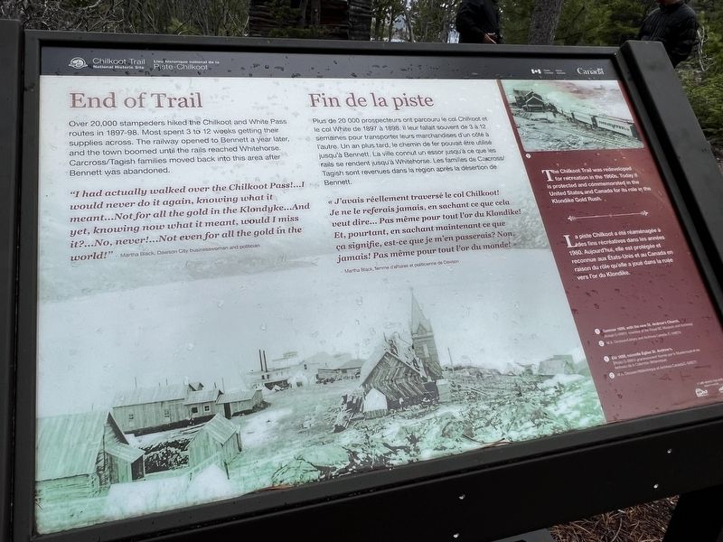
1. End of Trail Marker

Over 20,000 stampeders hiked the Chilkoot and White Pass routes in 1897--98. Most spent 3 to 12 weeks getting their supplies across. The railway opened to Bennett a year later, and the town boomed until the rails reached Whitehorse. Carcross/Tagish families moved back into this area after Bennett was abandoned.
"I had actually walked over the Chilkoot Pass!…I would never do it again, knowing what it meant…Not for all the gold in the Klondyke…And yet, knowing now what it meant, would I miss it?…No, never!…Not even for all the gold in the world!" - Martha Black, Dawson City businesswoman and politician
« J'avais réellement traversé le col Chilkoot! Je ne le referais jamais, en sachant ce que cela veut dire… Pas même pour tout l'or du Klondike! Et, pourtant, en sachant maintenant ce que ça signifie, est-ce que je m'en passerais? Non, jamais! Pas même pour tout l'or du monde! »
- Martha Black, femme d'affaires et politicienne de Dawson
The Chilkoot Trail was redeveloped for recreation in the 1960s. Today it is predotected and commemorated in the United States and Canada for its role in the Klondike Gold Rush.
Erected by Parks
this page online
Topics. This historical marker is listed in these topic lists: Indigenous Peoples and Communities • Railroads & Streetcars. A significant historical year for this entry is 1898.
Location. 59° 50.72′ N, 134° 59.963′ W. Marker is in Bennett, British Columbia, in Stikine Region. It can be reached from Chilkoot Trail (British Columbia Route 98) 19.3 kilometers north of Dyea Road, on the right when traveling north. Touch for map. Marker is in this post office area: Bennett BC V0W 1A0, Canada. Touch for directions.

Regionally, this marker is in Northern BC. Globally, it is in North America, on the Ring of Fire, in the Pacific Rim, in the Western Hemisphere, in the Western World, and in the Anglosphere. Historically, it finds itself in what was once a British colony.
Other nearby markers. At least 7 other markers are within 16 kilometers of this marker, measured as the crow flies: St. Andrew's Church / Église St. Andrew's (a few steps from this marker); Welcome / Bienvenue (within shouting distance of this marker); Chilkoot Trail National Historic Site / Lieu historique national de la Piste-Chilkoot (within shouting distance of this marker); A Precious Place / Un endroit préciux (about 90 meters away, measured in a direct line); Names on the land / Noms de la terre (about 90 meters away); Fraser (approx. 14.4 kilometers away); a different marker also named Fraser (approx. 14.7 kilometers away).
Credits. This page was last revised on July 27, 2026. It was originally submitted on June 17, 2024, by Sandra Hughes Tidwell of Killen, Alabama, USA. This page has been viewed 130 times since then and 20 times this year. Photo 1. submitted on June 17, 2024, by Sandra Hughes Tidwell of Killen, Alabama, USA. • Devry Becker Jones was the editor who published this page.
Editor’s want-list for this marker. A wide shot of the marker in context • Can you help?
