Ogdensburg in St. Lawrence County, New York — The American Northeast (Mid-Atlantic)
An Outdoor Geology Museum
Shaped by Rock, Water, & Ice
| — | Natural History | — |
Photographed by William Fischer, Jr., June 17, 2024
1. An Outdoor Geology Museum Marker
Great Lakes Seaway Trail bedrock and surficial geology form a foundation for scenic spectacles
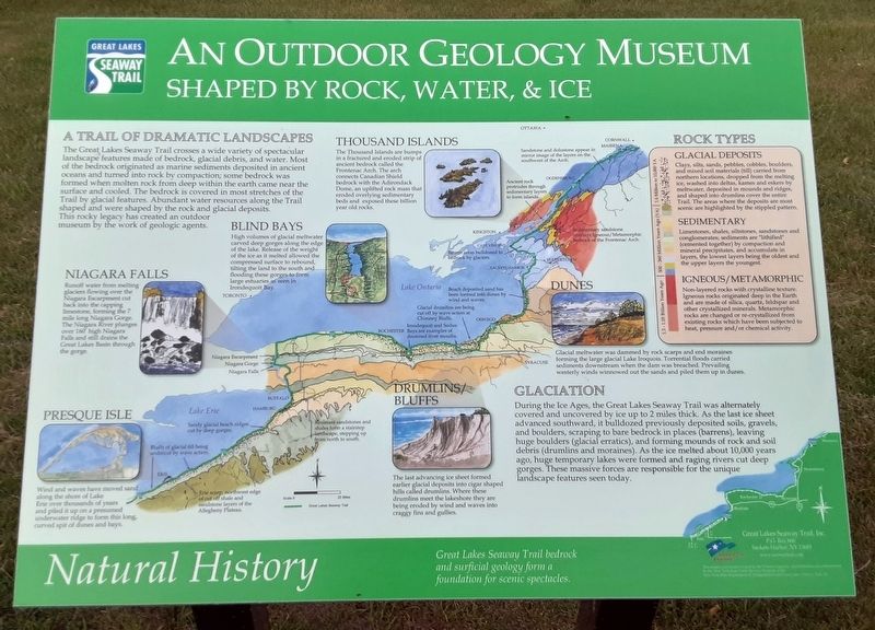
A TRAIL OF DRAMATIC LANDSCAPES
The Great Lakes Seaway Trail crosses a wide variety of spectacular landscape features made of bedrock, glacial debris, and water. Most of the bedrock originated as maritime sediments deposited in ancient oceans and turned into rock by compaction; some bedrock was formed when molten rock from deep within the earth came near the surface and cooled. The bedrock is covered in most stretches of the Trail by glacial features. Abundant water resources along the Trail shaped and were shaped by the rock and glacial deposits. This rocky legacy has created an outdoor museum by the work of geologic agents.
GLACIATION
During the Ice Ages, the Great Lakes Seaway Trail was alternately covered and uncovered by ice up to 2 miles thick. As the last ice sheet advanced southward, it bulldozed previously deposited soils, gravels, and boulders, scraping to bare bedrock in places (barrens), leaving huge boulders (glacial erratics), and forming mounds of rock and soil debris (drumlins and moraines). As the ice melted
this page online
[Notable natural features along New York's inland "coastline," from west to east]
Presque Isle [in far NW Pennsylvania]
Wind and waves have moved sand along the shore of Lake Erie over thousands of years and piled it up on a presumed underwater ridge to form this long, curved spit of dunes and bays.
Niagara Falls
Runoff water from melting glaciers flowing over the Niagara Escarpment cut back into the capping limestone, forming the 7 mile long Niagara Gorge. The Niagara River plunges over 160' high Niagara Falls and still drains the Great Lakes Basin through the gorge.
Blind Bays
High volumes of glacial meltwater carved deep gorges along the edge of the lake. Release of the weight of the ice as it melted allowed the compressed surface to rebound, tilting the land to the south and flooding these gorges to form large estuaries as seen in Irondequoit Bay.
Drumlins/Bluffs
The last advancing ice sheet formed earlier glacial deposits into cigar shaped hills called
Photographed by William Fischer, Jr., June 17, 2024
2. An Outdoor Geology Museum Marker
Dunes
Glacial meltwater was dammed by rock scarps and end moraines forming the large glacial Lake Iroquois. Torrential floods carried sediments downstream when the dam was breached. Prevailing westerly winds winnowed out the sands and piled them up in dunes.
Thousand Islands
The Thousand Islands are bumps in the fractured and eroded strip of ancient bedrock called the Frontenac Arch. The arch connects Canadian Shield bedrock with the Adirondack Dome, an uplifted rock mass that eroded overlying sedimentary beds and exposed these billion year old rocks.
ROCK TYPES
Glacial Deposits
Clays, silts, sands, pebbles, cobbles, boulders, and mixed soil materials (till) carried from northern locations, dropped from the melting ice, washed into deltas, kames and eskers by meltwater, deposited in mounds and ridges, and shaped into drumlins cover the entire Trail. The areas where the deposits are most scenic are highlighted by the stippled pattern.
Sedimentary
Limestones, shales, siltstones, sandstones and conglomerates; sediments are "lithified" (cemented together) by compaction and mineral precipitates, and accumulate in layers, the lowest layers being the oldest and the upper layers the youngest.
Igneous/Metamorphic
Non-layered rocks with crystalline texture. Igneous rocks originated deep in the Earth and are made of silica, quartz, feldspar and other crystallized minerals. Metamorphic rocks are changed or re-crystallized from existing rocks which have been subjected to heat, pressure and/or chemical activity.
[Small notes along the Trail/coastline map are not transcribed]
Erected by Great Lakes Seaway Trail, Inc.
Topics. This historical marker is listed in this topic list: Natural Features.
Location. 44° 41.715′ N, 75° 30.118′ W. Marker is in Ogdensburg, New York, in St. Lawrence County. It can be reached from Albany Avenue. Marker is along the Abbe Picquet Walking Trail at Fort de La Présentation, parking accessed along Albany Avenue north of New York Route 68. Touch for map. Marker is in this post office area: Ogdensburg NY 13669, United States of America. Touch for directions.

Regionally, this marker is in Upstate New York and in the Adirondacks & North Country. It is also in the American Northeast and in the Mid-Atlantic. Globally, it is in North America, the Western Hemisphere, the Western World, and the Anglosphere. Historically, it finds itself in what was once the Viceroyalty of New France, the Haudenosaunee (Iroquois) Confederacy, New Netherland, and one of the original Thirteen Colonies.
Other nearby markers. At least 8 other markers are within walking distance of this marker: Fort la Présentation (about 400 feet away, measured in a direct line); Fort de la Présentation - 1749-1759 (about 400 feet away); Fort Lévis - 1760 (about 400 feet away); Fort Oswegatchie 1760-1796 (about 400 feet away); The Battle of Ogdensburg (about 400 feet away); Aka Se We':Ka Tsi (Oswegatchie) (about 400 feet away); Fort de la Présentation (about 400 feet away); 300 Years of Artifacts, Refuse and Pollution (about 400 feet away). Touch for a list and map of all markers in Ogdensburg.
Also see . . .
1. The Great Lakes in Ancient Times and a Glimpse into the Future (Williams, Summer 1962). (Submitted on June 20, 2024, by William Fischer, Jr. of Reynoldsburg, Ohio.)
2. Great Lakes Seaway Trail – NY. (Submitted on June 20, 2024, by William Fischer, Jr. of Reynoldsburg, Ohio.)
Credits. This page was last revised on February 28, 2026. It was originally submitted on June 20, 2024, by William Fischer, Jr. of Reynoldsburg, Ohio. This page has been viewed 193 times since then and 26 times this year. Photos: 1, 2. submitted on June 20, 2024, by William Fischer, Jr. of Reynoldsburg, Ohio.
