
City Centre West in York, England, United Kingdom — Northwestern Europe (the British Isles)
Micklegate Bar

Photographed by Ray Gurganus, April 16, 2024
1. Micklegate Bar Marker
In 1642 Civil War broke out between King Charles I and Parliament. York remained loyal to the King and in April 1644 was besieged by a Parliamentarian army commanded by Yorkshireman Sir Thomas Fairfax. Charles's nephew, Prince Rupert, was sent to help York with an army of 15,000 men. He forced Fairfax's troops to break off the siege and retreat. While in pursuit, Rupert met disaster west of York at Marston Moor, where he suffered a crushing defeat. The siege was renewed and lasted until 16 July 1644 when the devastated Royalist Army opened Micklegate Bar and marched out in surrender.
Despite its proximity to one of the main areas of fighting, Micklegate Bar was not damaged during the siege. It was protected by the nearby Royalist fort on the Mount, which held out against the Parliamentarians who described it as 'a curious and strong work'.
The Railway Arrives
Walking the wall between Micklegate Bar and Lendal Bridge provides a whistle-stop tour of York's great railway heritage. In 1841 a railway station opened the City Walls. In order to get trains in the section of the wall and rampart was demolished and
this page online
As rail traffic increased, more lines were needed and in 1845 a second arch was cut through the wall. In 1876 third one was cut to provide access to the city centre from the new railway station which opened outside the walls in 1877. It was the largest in the country and seen by many as 'a monument to extravagance.'
Underneath the Arches
Micklegate Bar incorporates a 12th-century outer arch and the walls of the passage are built with re-used on stone blocks and coffins. The rear of the Bar was rebuilt in 1827, replacing an earlier timber structure (like that at Walmgate Bar). A side arch for pedestrians was made as early as 1753, although the present flanking archways are Victorian.
Erected by City of York Council.
Topics. This historical marker is listed in these topic lists: Forts and Castles • Wars, Non-US. A significant historical date for this entry is July 16, 1644.
Location. 53° 57.354′ N, 1° 5.453′ W. Marker is in York, England. It is

Photographed by Ray Gurganus, April 16, 2024
2. City Wall and Micklegate Bar Marker, on left under arch

Regionally, this marker is in England’s Yorkshire & The Humber. Globally, it is on the Atlantic Ocean, in the North Atlantic Region, in Europe, in Atlantic Europe, on one of the British Isles, in the Western World, and in the Anglosphere. Historically, it finds itself in what was once the Roman Empire.
Other nearby markers. At least 8 other markers are within walking distance of this marker: The Siege of York 1644 (a few steps from this marker); Northeastern Railway War Memorial (approx. 0.3 kilometers away); North Eastern Railway Head Office (approx. 0.4 kilometers away); George Leeman (approx. 0.4 kilometers away); Afghanistan War Memorial (approx. 0.4 kilometers away); York War Memorial (approx. half a kilometer away); John Snow (approx. half a kilometer away); John Snow Memorial (approx. half a kilometer away). Touch for a list and map of all markers in York.
Also see . . . The Trail: Section 11. Micklegate Bar (Friends of York Walls).
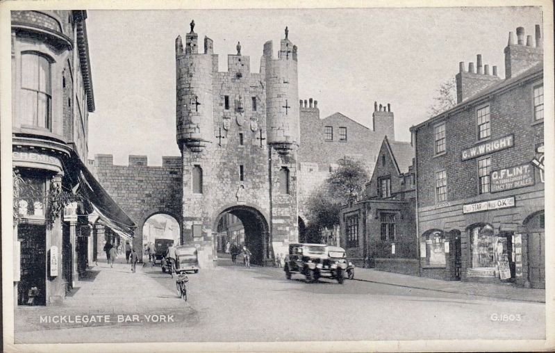
Photographed by Valentine and Sons, Ltd., circa 1928
3. Micklegate Bar, York
Excerpt: …This is called the principal bar because it guards the main road south, it’s the place where monarchs are greeted and it’s the main place where the heads of people these monarchs called traitors were shown off. Notice the modern stone figures on the battlements as you approach [and/or as you leave] the bar along the wall-walk –this is probably where the heads would have been spiked –the last ones were of supporters of Bonny Prince Charlie in 1745. He brought a Scots army further into England than York, scared York people into hurried repairs of the Walls but then retreated back to Scotland and defeat.(Submitted on July 6, 2024.)
Credits. This page was last revised on July 6, 2024. It was originally submitted on July 4, 2024, by Ray Gurganus of Washington, District of Columbia. This page has been viewed 164 times since then and 27 times this year. Photos: 1, 2. submitted on July 4, 2024, by Ray Gurganus of Washington, District of Columbia. 3. submitted on July 6, 2024. • Andrew Ruppenstein was the editor who published this page.
