
Chester in Cheshire West and Chester, England, United Kingdom — Northwestern Europe (the British Isles)
Heritage Features
Photographed by Ray Gurganus, April 9, 2024
1. Heritage Features Marker
1. Marquess Statue
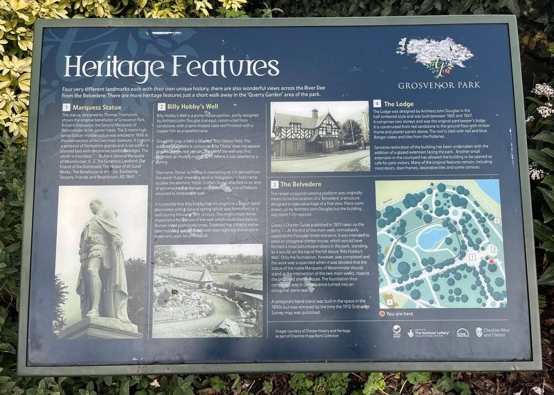
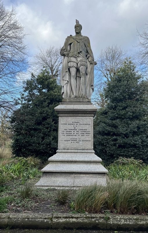
The statue designed by Thomas Thornicroft shows the original benefactor of Grosvenor Park, Richard Grosvenor the Second Marquess of Westminster in his garter robes. The 2-metre high white Sicilian marble statue was erected in 1868 at the intersection of the two main avenues. It sits on a pedestal of Derbyshire granite and is set within a planted bed with decorative sandstone edges. The plinth is inscribed "...Richard Second Marquess of Westminster, K.G. The Generous Landlord: The Friend of the Distressed: The Helper of all Good Works: The Benefactor to this City: Erected by Tenants, Friends and Neighbours: AD 1869..."
2. Billy Hobby's Well
Bully Hobby's Well is a pump house pavilion, partly designed by Architect John Douglas (canopy), constructed from sandstone, with a spire shaped slate roof finished with a copper fish as a weathervane.
On a 1745 map a field
this page online
The name 'Obbie' or Hobby is interesting as its derived from the word 'Hobb' meaning devil or hobgoblin; in field name studies the element 'Hobb' is often found attached to an area of perceived evil or danger, and there is still a lot of folklore attached to the present well.
It is possible that Billy Hobby has his origins in a pagan belief associated with a natural spring which was formalised en a well during the early 19th century. This might imply some importance for the site of the well which could date back to Roman if not prehistoric times. Tradition has it that in earlier days maidens would stand with the right leg immersed in water and wish for a husband.
3. The Belvedere
The raised octagonal viewing platform was originally meant to be the location of a 'Belvedere' structure designed to take advantage of a fine view. Plans were drawn up by Architect John Douglas but the building was never fully
Photographed by Ray Gurganus, April 9, 2024
2. Richard Grosvenor Statue
Geesty's Chester Guide published in 1873 takes up the story. At the end of the main walk immediately opposite the Foregate Street entrance, it was intended to erect an octagonal shelter-house, which would have formed a most picturesque object in the park, standing as it would on the top of the hill above 'Billy Hobby's Well'. Only the foundation; however, was completed and the work was suspended when it was decided that the statue of the noble Marquess of Westminster should stand at the intersection of the two main walks, close to the proposed shelter-house. The foundation thus competed was in consequence turned into a octagonal stone seat..."
A temporary band stand was built in the space in the 1890s but was removed by the time the 1912 Ordnance Survey map was published.
4. The Lodge
The Lodge was designed by Architect John Douglas in the half-timbered style and was built between 1865 and 1967. It comprises two storeys and was the original park keeper's lodge. It is constructed from red sandstone to the ground floor with timber frame and plaster panels above. The roof is tiled with red and blue Bangor slabes and tiles from the Potteries.
Sensitive restoration of the building has been undertaken with the addition of a glazed extension facing the park. Another small extension in the courtyard has allowed the building to be opened as cafe for park visitors. Many of the original features remain, including most doors, door frames, decorative tiles and some cornices.
Topics. This historical marker is listed in this topic list: Parks & Recreational Areas.
Location. 53° 11.384′ N, 2° 52.858′ W. Marker is in Chester, England, in Cheshire West and Chester. It can be reached from Grosvenor Park Terrace. in Grosvenor Park. Touch for map. Marker is in this post office area: Chester, England CH1 1SD, United Kingdom. Touch for directions.

Regionally, this marker is in North West England. Globally, it is on the Atlantic Ocean, in the North Atlantic Region, in Europe, in Atlantic Europe, on one of the British Isles, in the Western World, and in the Anglosphere. Historically, it finds itself in what was once the Roman Empire.
Other nearby markers. At least 8 other markers are within walking distance of this marker: North Eastern Chapel (approx. 0.3 kilometers away); South Eastern Chapel (approx. 0.3 kilometers away); The Chapter House (approx. 0.3 kilometers away); Ruins of the Church of St John the Baptist (approx. 0.3 kilometers away); Parker's Buildings (approx. 0.3 kilometers away); The Church of St John the Baptist (approx. 0.3 kilometers away); Eastern Ruins (approx. 0.3 kilometers away); a different marker also named The Church of St John the Baptist (approx. 0.4 kilometers away). Touch for a list and map of all markers in Chester.
Credits. This page was last revised on July 11, 2024. It was originally submitted on July 7, 2024, by Ray Gurganus of Washington, District of Columbia. This page has been viewed 143 times since then and 16 times this year. Photos: 1, 2. submitted on July 7, 2024, by Ray Gurganus of Washington, District of Columbia. • Bill Pfingsten was the editor who published this page.
