Albert Township in Lewiston in Montmorency County, Michigan — The American Midwest (Great Lakes)
The Michigan Home Colony

Photographed by Joel Seewald, July 1, 2024
1. The Michigan Home Colony Marker
In 1901 Cephus Buttles of Milwaukee, Wisconsin came to Lewiston to open the Michigan Home Colony land company. The Corporation purchased huge tracts of cutover land from the lumber companies at $1.25 per acre and resold the "fertile" open land for $5-$15 per acre to unsuspecting farmers looking to establish a homestead in Michigan. To prove the point of successful agriculture, Mr. Buttles raised pure bred Angus cattle at the family homestead, Angusdale Farm, still standing, 5 miles north of town.
The new settlers were recruited from neighboring states and a large group from Scandanavia [sic]. A new settlement of Finnish and Swedish families was established in the area of CR 612 and Townline Rd. Many ancestors [sic] of these hard working people remain in the area today. They were industrious folks, but the thin soil and short growing season made conditions very challenging.
After the railroads left the county transportation became very difficult and economic conditions nationwide turned bleak. Many farms were abandoned, and the few remaining turned to dairy, as it was not possible to sustain profitable crops in the
this page online
With the land boom over, the land company was dissolved and Mr. Buttles moved his family west to California. The Home Colony building continued to serve the community as the U.S. Post Office until it was torn down to make way for the first Standard Oil Gas Station in town in 1949.
Donated by Huston Real Estate.
The Lewiston Heritage Trail is a DDA project funded by private donors with period photos and historical text provided by the Lewiston Area Historical Society.
Erected by Lewiston Downtown Development Authority.
Topics. This historical marker is listed in these topic lists: Agriculture • Settlements & Settlers. A significant historical year for this entry is 1901.
Location. 44° 53.033′ N, 84° 18.342′ W. Marker is in Lewiston, Michigan, in Montmorency County. It is in Albert Township. It is at the intersection of Salling Avenue (County Road 612) and Kneeland Street, on the left when traveling west on Salling Avenue. Touch for map. Marker is at or near this postal address: 2980 Kneeland Street, Lewiston MI 49756, United States of America. Touch for directions.

Regionally, this marker is in Northern Michigan
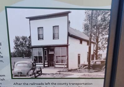
2. The Michigan Home Colony Marker — top image
Other nearby markers. At least 8 other markers are within walking distance of this marker: Lewiston Band Stand & Early Entertainment (within shouting distance of this marker); The First Telephone in Lewiston (within shouting distance of this marker); Village Park (within shouting distance of this marker); The First Lewiston Banks (within shouting distance of this marker); First Town Halls in Lewiston (about 300 feet away, measured in a direct line); M & H Company Store and Offices (about 400 feet away); The Lewiston House (about 500 feet away); The Sachs Hardware Building (about 500 feet away). Touch for a list and map of all markers in Lewiston.
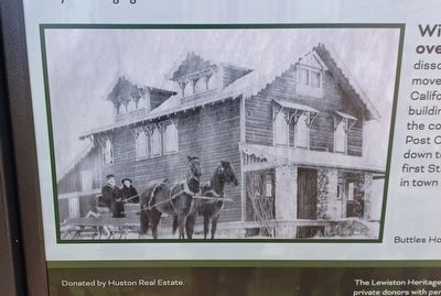
3. The Michigan Home Colony Marker — bottom image
Buttles Homestead, Angusdale Farm

Photographed by Joel Seewald, July 1, 2024
4. The Michigan Home Colony Marker
Credits. This page was last revised on July 8, 2024. It was originally submitted on July 7, 2024, by Joel Seewald of Madison Heights, Michigan. This page has been viewed 225 times since then and 37 times this year. Photos: 1, 2, 3, 4. submitted on July 7, 2024, by Joel Seewald of Madison Heights, Michigan.
