Waldorf in Charles County, Maryland — The American Northeast (Mid-Atlantic)
Mattawoman Run
Charles and Prince George's Counties
Photographed by F. Robby, November 10, 2009
1. Mattawoman Run Marker
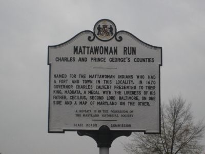
Named for the Mattawoman Indians who had a fort and town in this locality. In 1670 Governor Charles Calvert presented to their king, Maquata, a medal with the likeness of his father, Cecilius, second Lord Baltimore, on one side and a map of Maryland on the other.
Erected 1954 by State Roads Commission.
Topics and series. This historical marker is listed in these topic lists: Colonial Era • Forts and Castles • Settlements & Settlers. In addition, it is included in the Maryland Historical Trust series list. A significant historical year for this entry is 1670.
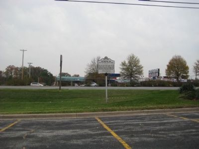
Location. Marker has been reported missing. It was located near 38° 39.385′ N, 76° 52.594′ W. Marker was in Waldorf, Maryland, in Charles County. It was on Crain Highway 0 miles south of Mattawoman Beantown Road (Maryland Route 205), on the right when traveling south. Touch for map. Marker was at or near this postal address: 12480 Mattawoman Dr, Waldorf MD 20601, United States of America. Touch for directions.

Regionally, this marker was in the Washington Metropolitan Area and in
this page online
Other nearby markers. At least 8 other markers are within 5 miles of this location, measured as the crow flies: John Wilkes Booth and his companion David Herold (approx. half a mile away); The Blue Jay Motel (approx. 1.3 miles away); Dr. Mudd's House (approx. 2.9 miles away); a different marker also named T. B. (approx. 3.1 miles away); Dr. Samuel A. Mudd House (approx. 4.2 miles away); Dr. Samuel A. Mudd (approx. 4.3 miles away); John Wilkes Booth (approx. 4.3 miles away); Home of Dr. Samuel Mudd (approx. 4.3 miles away). Touch for a list and map of all markers in Waldorf.
Other markers no longer nearby. T. B. (was approx. 3.1 miles away but has been replaced with another marker now near it); a different marker also named
Photographed by F. Robby, November 10, 2009
2. Mattawoman Run Marker
Additional commentary.
1. Correct year
The event commemorated on the marker actually occured on Septemmber 14, 1676. (Archives of Maryland, Volume 15, page 91; Proceedings of the Council of Maryland) The 1670 date on the marker is incorrect.
— Submitted September 12, 2012, by Tony Lopez of Hermosa beach, California.
2. Hull Plantation
My family the Stephen Cawood/Ann Terrett family at the time of 1675 until 1790 owned the Hull Plantation which is described as being located here; 1676, May 8, - Lord Baltimore granted the patent for the land called "Hull". the plantation still known as Hull lies 10 miles south of Washington, D.C., about three miles NE of the village of Waldorf in Charles Co., Maryland, and 5 miles as the crow flies from the point of the Potomac River opposite Mount Vernon. Hull Plantation is approached from the village of Waldorf. It sits 1/4 mile from the highway. I found where Stephen Cawood was killed by Indians and buried on the opposite side of the Potomac river in view of Mt Vernon. I have searched many maps and have been unable to locate Hull can anyone help with this?
— Submitted March 10, 2014, by George Alan Cawood of Bromley, Kentucky.
Credits. This page was last revised on December 27, 2024. It was originally submitted on November 15, 2009, by F. Robby of Baltimore, Maryland. This page has been viewed 3,289 times since then and 139 times this year. Last updated on July 7, 2024, by Rico Ramirez of Prince Frederick, Maryland. Photos: 1, 2. submitted on November 15, 2009, by F. Robby of Baltimore, Maryland. • Devry Becker Jones was the editor who published this page.
