Three Rivers in Otero County, New Mexico — The American Mountains (Southwest)
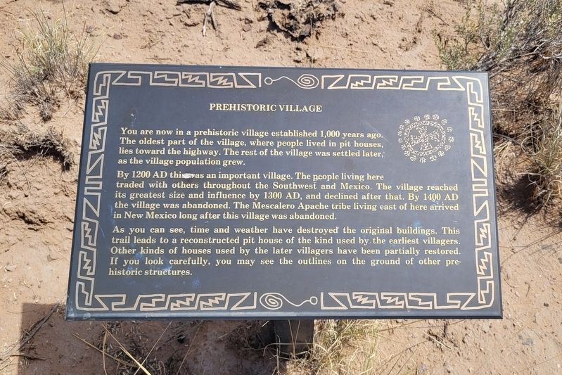
Prehistoric Village
Photographed by James Hulse, June 25, 2024
1. Prehistoric Village Marker
By 1200 AD this was an important village. The people living here traded with others throughout the Southwest and Mexico. The village reached its greatest size and influence by 1300 AD, and declined after that. By 1400 AD the village was abandoned. The Mescalero Apache tribe living east of here arrived in New Mexico long after this village was abandoned.
As you can see, time and weather have destroyed the original buildings. This trail leads to a reconstructed pit house of the kind used by the earliest villagers. Other kinds of houses used by the later villagers have been partially restored. If you look carefully, you may see the outlines on the ground of other pre- historic structures.
Topics. This historical marker is listed in these topic lists: Indigenous Peoples and Communities • Settlements & Settlers. A significant historical year for this entry is 1200.
Location. 33° 20.606′ N, 106° 0.432′ W.
this page online

Regionally, this marker is in the Pecos Valley. It is also in the American Borderlands and in the Southwest. Globally, it is in North America, the Western Hemisphere, the Western World, and the Anglosphere. Historically, it finds itself in what was once New Spain, the Comanchería, and the Republic of Texas.
Other nearby markers. At least 8 other markers are within walking distance of this marker: Leave Only Footprints (within shouting distance of this marker); Home - 1000 Years Ago (about 400 feet away, measured in a direct line); Adobe Surface House (about 400 feet away); Building of a Later Period (about 500 feet away); The First People (about 500 feet away); Three Rivers Petroglyph Site (about 800 feet away); Sacramento Mountains (approx. 0.3 miles away);

Photographed by James Hulse, June 25, 2024
2. Prehistoric Village Marker
Also see . . . Three Rivers Petroglyph Site. Bureau of Land Management
The Three Rivers Petroglyphs are outstanding examples of prehistoric Jornada Mogollon rock art. The basaltic ridge rising above the Three Rivers Valley contains over 21,000 petroglyphs, including masks, sunbursts, wildlife, handprints, and geometric designs. The number and concentration of petroglyphs make this one of the largest and most interesting rock art sites in the Southwest. A rugged 0.5-mile trail (Petroglyph Trail) begins at the visitor shelter and links many of the most interesting petroglyphs. Another short trail (Village Trail) begins on the east side of the picnic area and leads to a partially excavated prehistoric village.(Submitted on July 12, 2024, by James Hulse of Medina, Texas.)
The Three Rivers Petroglyph Site is one of the few locations in the Southwest set aside solely because of its rock art. It is also one of the few sites giving visitors such direct access to petroglyphs. The number and concentration of petroglyphs here make it one of the largest and most interesting petroglyphs sites in the Southwest. More than 21,000 glyphs of birds, humans, animals, fish, insects and plants, as well as numerous geometric and abstract designs are scattered over 50 acres of New Mexico's northern Chihuahuan Desert. The petroglyphs at Three Rivers, dating back to between about 200-1450 AD, were created by Jornada Mogollon people who used stone tools to remove the dark patina on the exterior of the rock. A small pithouse is nearby and Sierra Blanca towers above to the east. A detailed petroglyph guide is available at the Three Rivers Petroglyph Site.

Photographed by James Hulse, June 25, 2024
3. The view of the Prehistoric Village Marker along the trail
Credits. This page was last revised on July 12, 2024. It was originally submitted on July 11, 2024, by James Hulse of Medina, Texas. This page has been viewed 203 times since then and 13 times this year. Photos: 1, 2, 3. submitted on July 12, 2024, by James Hulse of Medina, Texas.
