Near Hancock in Washington County, Maryland — The American Northeast (Mid-Atlantic)
Explore Maryland Civil War Trails
Adventure Waits
Photographed by J. J. Prats, July 10, 2024
1. Explore Maryland Civil War Trails Marker
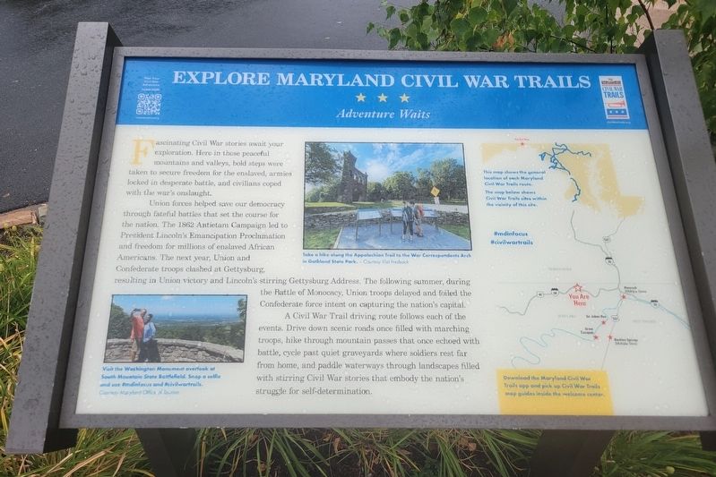
Fascinating Civil War stories await your exploration. Here in those peaceful mountains and valleys, bold steps were taken to secure freedom for the enslaved, armies locked in desperate battle, and civilians coped with the war's onslaught.
Union forces helped save our democracy through fateful battles that set the course for the nation. The 1862 Antietam Campaign led to President Lincoln's Emancipation Proclamation and freedom for millions of enslaved African Americans. The next year, Union and Confederate troops clashed at Gettysburg, resulting in Union victory and Lincoln's stirring Gettysburg Address. The following summer, during the Battle of Monocacy, Union troops delayed and foiled the Confederate force intent on capturing the nation's capital.
A Civil War Trail driving route follows each of the events. Drive down scenic roads once filled with marching troops, hike through mountain passes that once echoed with battle, cycle past quiet graveyards where soldiers rest far from home, and paddle waterways through landscapes filled with stirring Civil War stories that embody the nation's struggle for self-determination.
Erected by Maryland
this page online
Topics and series. This historical marker is listed in this topic list: War, US Civil. In addition, it is included in the Maryland Civil War Trails series list. A significant historical year for this entry is 1862.
Location. 39° 42.948′ N, 78° 16.861′ W. Marker is near Hancock, Maryland, in Washington County. It is on Sideling Hill Rest Area, Eastbound (Interstate 68) 3 miles east of Exit 74, on the right when traveling east. Touch for map. Marker is at or near this postal address: US-40, Hancock MD 21750, United States of America. Touch for directions.

Regionally, this marker is in Western Maryland. It is also in the American Mid-Atlantic, in Appalachia, and specifically in Northern Appalachia. Globally, it is in North America, the Western Hemisphere, the Western World, and the Anglosphere. Historically, it finds itself in what was once one of the original Thirteen Colonies.
Other nearby markers. At least 8 other markers are within 4 miles of this marker, measured as the crow flies: Interstate 68 Maryland Vietnam Memorial (about 800 feet away, measured in a direct line); a different marker also named Explore Maryland Civil War Trails
Photographed by J. J. Prats, July 10, 2024
2. Explore Maryland Civil War Trails Marker
Other markers no longer nearby. Gettysburg Campaign (was a few steps from this marker but has been replaced with another marker now near it); Sideling Hill Cut North Bench (was approx. 0.2 miles away but has been permanently removed); a different marker also named Gettysburg Campaign (was approx. 0.2 miles away but has been replaced with another marker now near it); The National Road (was approx. 0.2 miles away but has been permanently removed); The Challenge of Sideling Hill (was approx. 0.2 miles away but has been replaced with another marker now near it); a different marker also named The Challenge of Sideling Hill (was approx. 0.2 miles away but has been replaced with another marker
![Explore Your Chesapeake [Adjacent sign] image. Click for full size.](Photos9/972/Photo972863.jpg?913202670300PM "Explore Your Chesapeake [Adjacent sign]. Click for full size.")
Photographed by Devry Becker Jones (CC0), September 12, 2026
3. Explore Your Chesapeake [Adjacent sign]
Welcome to the Chesapeake region, a place that celebrates the natural and cultural heritage of the Chesapeake Bay and its rivers. Discover our proud traditions and precious resources at Chesapeake Bay Gateways.
The Chesapeake Bay Gateways Network unites more than 150 parks, wildlife refuges, maritime museums, historic sites and water trails across the Bay watershed. visit them all and enjoy the full meaning of the Chesapeake story.
Let us be your guide: Take a map of these special places, talk to a travel counselor and explore your Chesapeake! Visit us at www.baygetaways.net or call 1-866-BAYWAYS
More about this marker. This interpretive panel is illustrated with two photographs, a map which shows "the general location of each Maryland Civil War Trails route" superimposed on an outline map of the state, and a more detailed map showing the "Civil War Trails sites within the vicinity of this site."
The photographs are captioned,
Visit the Washington Monument overlook at South Mountain State Battlefield. Snap a selfie and use #mdinfocus and #civilwartrails.
Take a hike along the Appalachian Trail to the War Correspondents Arch in Gothland State Park.
Credits. This page was last revised on September 13, 2026. It was originally submitted on July 11, 2024, by J. J. Prats of Powell, Ohio. This page has been viewed 406 times since then and 53 times this year. Photos: 1, 2. submitted on July 11, 2024, by J. J. Prats of Powell, Ohio. 3. submitted on September 13, 2026, by Devry Becker Jones of Washington, District of Columbia.
