Near Amsterdam in Montgomery County, New York — The American Northeast (Mid-Atlantic)
Schoharie Crossing
State Historic Site
Photographed by Steve Stoessel, July 14, 2024
1. Schoharie Crossing Marker
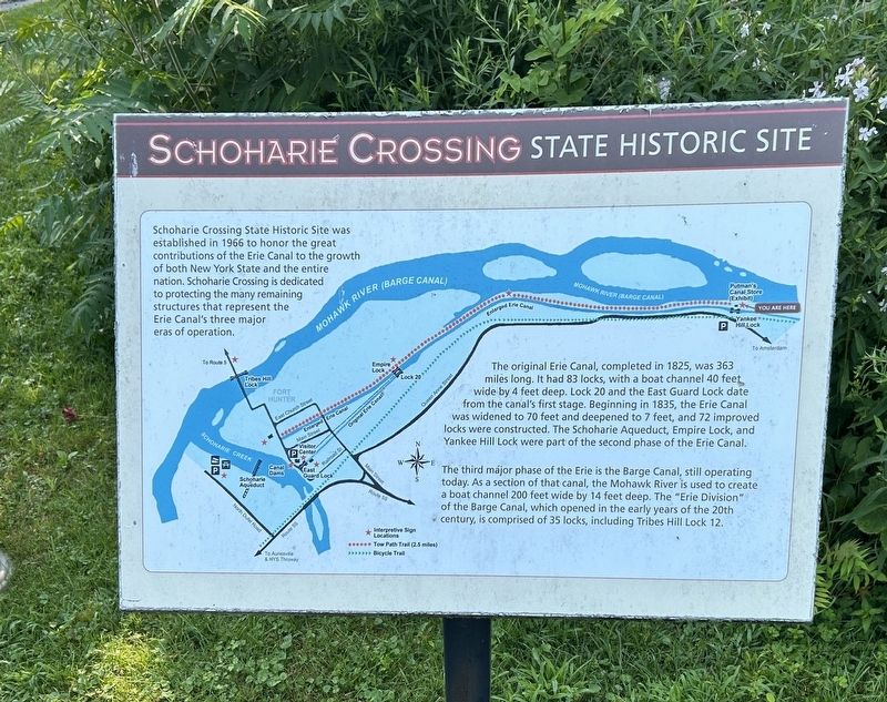
Schoharie Crossing State Historic Site was established in 1966 to honor the great contributions of the Erie Canal to the growth of both New York State and the entire nation. Schoharie Crossing is dedicated to protecting the many remaining structures that represent the Erie Canal's three major eras of operation
The original Erie Canal, completed in 1825, was 363 miles long. It had 83 locks, with a boat channel 40 feet wide by 4 feet deep. Lock 20 and the East Guard Lock date from the canal's first stage. Beginning in 1835, the Erie Canal was widened to 70 feet and deepened to 7 feet, and 72 improved locks were constructed. The Schoharie Aqueduct, Empire Lock, and Yankee Hill Lock were part of the second phase of the Erie Canal.
The third major phase of the Erie is the Barge Canal, still operating today. As a section of that canal, the Mohawk River is used to create a boat channel 200 feet wide by 14 feet deep. The "Erie Division" of the Barge Canal, which opened in the early years of the 20th century, is comprised of 35 locks, including Tribes Hill Lock 12.
Topics. This historical marker is listed in
this page online
Location. 42° 57.155′ N, 74° 14.284′ W. Marker is near Amsterdam, New York, in Montgomery County. It can be reached from the intersection of Queen Anne Road and Empire State Trail, on the right when traveling north. Marker is in the parking area for Yankee Hill Lock. Touch for map. Marker is in this post office area: Amsterdam NY 12010, United States of America. Touch for directions.

Regionally, this marker is in Upstate New York and in the Mohawk Valley. It is also in the American Northeast and in the Mid-Atlantic. Globally, it is in North America, the Western Hemisphere, the Western World, and the Anglosphere. Historically, it finds itself in what was once the Haudenosaunee (Iroquois) Confederacy, New Netherland, and one of the original Thirteen Colonies.
Other nearby markers. At least 8 other markers are within walking distance of this marker: Lock 28 - Yankee Hill Lock (a few steps from this marker); Putman's Lock Grocery (a few steps from this marker); Two Problems Solved (within shouting distance of this marker); The Last Improvements
Photographed by Steve Stoessel, July 14, 2024
2. Schoharie Crossing Marker
Also see . . .
1. Schoharie Crossing (Wikipedia). (Submitted on July 16, 2024, by Steve Stoessel of Niskayuna, New York.)
2. Erie Canal (Wikipedia). (Submitted on July 16, 2024, by Steve Stoessel of Niskayuna, New York.)
Credits. This page was last revised on July 16, 2024. It was originally submitted on July 14, 2024, by Steve Stoessel of Niskayuna, New York. This page has been viewed 160 times since then and 20 times this year. Photos: 1, 2. submitted on July 14, 2024, by Steve Stoessel of Niskayuna, New York.
