
Clearfield in Clearfield County, Pennsylvania — The American Northeast (Mid-Atlantic)
West Branch Susquehanna River Water Trail
Photographed by William Fischer, Jr., July 12, 2024
1. West Branch Susquehanna River Water Trail Marker
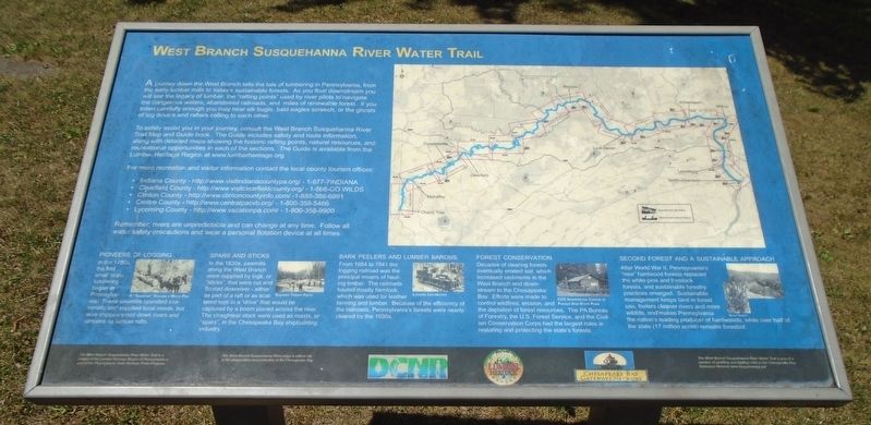
A journey down the West Branch tells the tale of lumbering in Pennsylvania, from the early lumber mills to today's sustainable forests. As you float downstream you will see the legacy of lumber; the "rafting points" used by river pilots to navigate the dangerous waters, abandoned railroads, and miles of renewable forest, If you listen carefully enough you may hear elk bugle, bald eagles screech, or the ghosts of log drivers and rafters calling to each other.
To safely assist you in your journey, consult the West Branch Susquehanna River Trail Map and Guide book. The Guide includes safety and route information, along with detailed maps showing the historic rafting points, natural resources, and recreational opportunities in each of the sections. The Guide is available from the Lumber Heritage Region at www.lumberheritage.org.
For more recreation and visitor information contact the local county tourism offices:
• Indiana County - http://www.visitindianacountypa.org/ -1-877-7INDIANA
• Clearfield County - http://www.visitclearfieldcounty.org/ - 1-866-GOWILDS
• Clinton County - http://www.clintoncountyinfo.com/ - 1-888-388-6991
this page online
• Lycoming County - http://www.vacationpa.com/ - 1-800-358-9900
Remember, rivers are unpredictable and can change at any time. Follow all water safety precautions and wear a personal flotation devise at all times.
Pioneers of Logging
In the 1780s the first small scale lumbering began in Pennsylvania. These sawmills operated seasonally and supplied local neds, but also shipped wood down rivers and streams as lumber rafts.
Spars and Sticks
In the 1830s, sawmills along the West Branch were supplied by logs or "sticks", that were cut and floated downriver - either as part of a raft or as scattered logs in a "drive" that would be captured by a boom placed across the river. The straightest stock were used as masts, or "spars", in the Chesapeake Bay shipbuilding industry.
Bark Peelers and Lumber Barons
From 1864 to 1941 the logging railroad was the principal means of hauling timber. The railroads hauled mostly hemlock, which was used for leather tanning and lumber. Because of the efficiency of the railroads, Pennsylvania's forests were nearly cleared by the 1930s.
Forest Conservation
Decades
Photographed by William Fischer, Jr., July 12, 2024
2. West Branch Susquehanna River Water Trail Marker
Second Forest and a Sustainable Approach
After World War II, Pennsylvania's "new" hardwood forests replaced the white pine and hemlock forests, and sustainable forestry practices emerged. Sustainable management keeps land in forest use, fosters cleaner rivers and more wildlife, and makes Pennsylvania the nation's leading producer of hardwoods, while over half of the state (17 million acres) remains forested.
Erected by PA DCNR, Lumber Heritage Region, and Chesapeake Bay Gateways Network.
Topics. This historical marker is listed in these topic lists: Horticulture & Forestry • Industry & Commerce • Railroads & Streetcars • Waterways & Vessels. A significant historical year for this entry is 1864.
Location. 41° 1.425′ N, 78° 26.422′ W. Marker is in Clearfield, Pennsylvania, in Clearfield County. It is on Front Street (Pennsylvania Route 153) just north of Locust Street, on the right when traveling south. Marker is in Lower Witmer Park. Touch for map. Marker is at or near this postal address: 2 East Locust Street, Clearfield PA 16830, United States of America. Touch for directions.

Regionally, this marker is in the Pennsylvania Wilds. It is also in the American Northeast, in the Mid-Atlantic, in Appalachia, and specifically in Northern Appalachia. Globally, it is in North America, the Western Hemisphere, the Western World, and the Anglosphere. Historically, it finds itself in what was once the Haudenosaunee (Iroquois) Confederacy and also one of the original Thirteen Colonies.
Other nearby markers. At least 8 other markers are within walking distance of this marker: Roger W. Bell (a few steps from this marker); Civilization in the Wilds (within shouting distance of this marker); Discover the Lumber Heritage Region (within shouting distance of this marker); Clearfield's Early Inhabitants (within shouting distance of this marker); Clearfield County (about 300 feet away, measured in a direct line); Old Town Historic District (about 400 feet away); Clearfield County Historical Society (about 400 feet away); Clearfield County Bicentennial Raft (about 400 feet away). Touch for a list and map of all markers in Clearfield.
Related marker. Click here for another marker that is related to this marker.
Also see . . .
1. Lumber Heritage Region. (Submitted on July 14, 2024, by William Fischer, Jr. of Reynoldsburg, Ohio.)
2. Log rafts and raftmen once ruled the Susquehanna River (Bay Journal, 2023). (Submitted on July 14, 2024, by William Fischer, Jr. of Reynoldsburg, Ohio.)
Credits. This page was last revised on December 16, 2024. It was originally submitted on July 14, 2024, by William Fischer, Jr. of Reynoldsburg, Ohio. This page has been viewed 212 times since then and 11 times this year. Photos: 1, 2. submitted on July 14, 2024, by William Fischer, Jr. of Reynoldsburg, Ohio.
