Brownville in Nemaha County, Nebraska — The American Midwest (Upper Plains)
Lewis and Clark Campsite
July 15, 1804

Photographed by Mark Hilton, July 11, 2024
1. Lewis and Clark Campsite Marker
Soon after embarking the next morning, the expedition’s keelboat caught on a snag in the river. Despite the delay, the explorers traveled 20 miles on July 16.
Erected by Nebraska State Historical Society, National Park Service. (Marker Number 338.)
Topics and series. This historical marker is listed in these topic lists: Exploration • Waterways & Vessels.
this page online
Location. 40° 23.695′ N, 95° 39.097′ W. Marker is in Brownville, Nebraska, in Nemaha County. It is on East Water Street, on the right when traveling south. Located near the Captain Meriwether Lewis Dredge. Touch for map. Marker is at or near this postal address: 1 E Water St, Brownville NE 68321, United States of America. Touch for directions.

Regionally, this marker is in Eastern Nebraska. It is also in the American Midwest, in the Lewis & Clark Corridor, in the Corn Belt, and on the prairies. Globally, it is in North America, the Western Hemisphere, the Western World, and the Anglosphere. Historically, it finds itself in what was once the Louisiana Purchase.
Other nearby markers. At least 8 other markers are within walking distance of this marker: The Nebraska House (about 800 feet away, measured in a direct line); The Large One-bottom Plow (approx. ¼ mile away); Co. C. 1st Reg. of Nebraska (approx. 0.3 miles away); Late 1800's Road Grader (approx. 0.3 miles away);

Photographed by Mark Hilton, July 11, 2024
2. Lewis and Clark Campsite Marker with the Captain Meriwether Lewis Dredge in background.
A week earlier, the Missouri River overflowed due to extensive rain. The area around the marker was water logged with deep mud. Could not remove the weeds to get a better photo.
Also see . . . Journals of the Lewis & Clark Expedition for July 15th, 1804. (Submitted on July 14, 2024, by Mark Hilton of Montgomery, Alabama.)
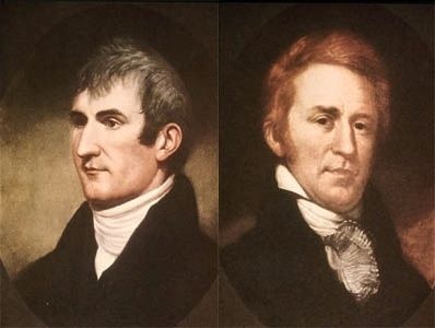
Public Domain
3. Captain Meriwether Lewis & Second Lieutenant William Clark.
Credits. This page was last revised on July 15, 2024. It was originally submitted on July 14, 2024, by Mark Hilton of Montgomery, Alabama. This page has been viewed 307 times since then and 48 times this year. Photos: 1, 2, 3. submitted on July 14, 2024, by Mark Hilton of Montgomery, Alabama.
Editor’s want-list for this marker. Clearer photo of marker. • Can you help?
