Near Highland in Doniphan County, Kansas — The American Midwest (Upper Plains)
Glaciers
Ancient ice sheets shaped northeast Kansas' landscape
| — | Glacial Hills Scenic Byway | — |
Photographed by Mark Hilton, July 11, 2024
1. Glaciers Marker
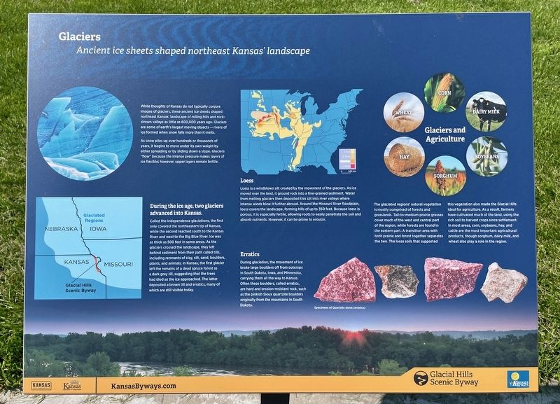
While thoughts of Kansas do not typically conjure images of glaciers, these ancient ice sheets shaped northeast Kansas' landscape of rolling hills and rock-strewn valleys as little as 600,000 years ago. Glaciers are some of earth's largest moving objects - rivers of ice formed when snow falls more than it melts. As snow piles up over hundreds or thousands of years, it begins to move under its own weight by either spreading or by sliding down a slope. Glaciers "flow" because the intense pressure makes layers of ice flexible; however, upper layers remain brittle.
During the ice age, two glaciers advanced into Kansas.
Called the Independence glaciations, the first only covered the northeastern tip of Kansas, while the second reached south to the Kansas River and west to the Big Blue River. Ice was as thick as 500 feet in some areas. As the glaciers crossed the landscape, they left behind sediment from their path called tills, including remnants of clay, silt, sand, boulders, plants, and animals. In Kansas, the first glacier left the remains of a dead spruce forest as a dark gray till, suggesting that the trees had died
this page online
Loess
Loess is a windblown silt created by the movement of the glaciers. As ice moved over the land, it ground rock into a fine-grained sediment. Water from melting glaciers then deposited this silt into river valleys where intense winds blew it further abroad. Around the Missouri River floodplain, loess covers the landscape, forming hills of up to 350 feet. Because loess is porous, it is especially fertile, allowing roots to easily penetrate the soil and absorb nutrients. However, it can be prone to erosion.
Erratics
During glaciation, the movement of ice broke large boulders off from outcrops in South Dakota, lowa, and Minnesota, carrying them all the way to Kansas. Often these boulders, called erratics, are hard and erosion-resistant rock, such as the pinkish Sioux quartzite boulders originally from the mountains in South Dakota.
Glaciers and Agriculture
The glaciated regions' natural vegetation is mostly comprised of forests and grasslands. Tall-to-medium prairie grasses cover much of the west and central part

Photographed by Mark Hilton, July 11, 2024
2. Glaciers Marker (on left of three). KS-7 highway in background.
Erected by Kansas Tourism, Kansas Department of Transportation.
Topics. This historical marker is listed in this topic list: Environment.
Location. 39° 55.782′ N, 95° 14.288′ W. Marker is near Highland, Kansas, in Doniphan County. It is at the intersection of Dove Creek Road and State Route 7, on the right when traveling north on Dove Creek Road. Located at Iowa Point. Touch for map. Marker is in this post office area: Highland KS 66035, United States of America. Touch for directions.

Regionally, this marker is in Eastern Kansas. It is also in the American Midwest, in the Lewis & Clark Corridor, in the Corn Belt, on the prairies, and on the Southern Plains. Globally, it is in North America, the Western Hemisphere, the Western World, and the Anglosphere. Historically, it finds itself in what was once the Louisiana Purchase.
Other nearby markers. At least 8 other markers are within 5 miles of this marker, measured as the crow flies: Landscape of the Glacial Hills (here, next to this marker); The Barns of Doniphan County (here, next to this marker); Homeland of the Kanza Indians (approx. 4½ miles away); "the water…contains a half…Glass of ooze" (approx. 4½ miles away); The Lewis and Clark Expedition (approx. 4½ miles away); Glacial Hills Scenic Byway (approx. 4½ miles away); Wilbur Chapman (approx. 4½ miles away); July 10, 1804 (approx. 4½ miles away). Touch for a list and map of all markers in Highland.
Another marker is no longer nearby. "abounds with Beaver" (was approx. 3.2 miles away but has been confirmed missing).
Credits. This page was last revised on July 23, 2024. It was originally submitted on July 23, 2024, by Mark Hilton of Montgomery, Alabama. This page has been viewed 347 times since then and 66 times this year. Photos: 1, 2. submitted on July 23, 2024, by Mark Hilton of Montgomery, Alabama.
