
Near New Market in Frederick County, Maryland — The American Northeast (Mid-Atlantic)
Mile Stones of the old National Pike
| — | The Road That Built The Nation | — |

Photographed by Devry Becker Jones (CC0), July 28, 2024
1. Mile Stones of the old National Pike Marker
Looking more like an ancient tombstone, the stone marker at the bottom of the hill before you, tucked inside the guardrail, was once used to denote mileage to Baltimore along the Baltimore and Frederick-Town Turnpike, also known as the old National Pike.
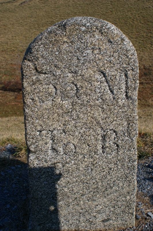
Long before automobiles sped along this corridor and synthetic materials were used for highway signs, mileage signs were literally carved in stone! Although it has worn away over time, hand-chiseled letters and numbers once read 35 M to B, and meant 35 miles to Baltimore.
This tradition dates back over 2000 years to the road builders of the Roman Empire, and it continued in 19th century America.
Forty-five markers were placed along the turnpike from Baltimore to Frederick, one mile apart, primarily on the north side of the road. Mile stones were a welcome sign for a weary traveler plodding along at a slow pace in a horse-drawn carriage or wagon. Heavily laden wagons often covered only a few miles a day.
Although built to last, the permanency of some mile stones has been usurped by road improvements that accommodated modern travelers. Only a few remain in their
this page online
[Sidebar:]
Traffic Jams Are Nothing New
This stretch of the National Pike once bustled with merchants and farmers transporting raw materials and farm products in horse-drawn wagons to markets in the east. James Buckingham, an early traveler on the road, described his fellow passengers as "being farmers, country-dealers, and speculators, passing from town to town" and noted a "spirit of mutual forbearance and good nature."
Erected by America's Byways; Maryland Heritage Areas Authority.
Topics and series. This historical marker is listed in these topic lists: Communications • Roads & Vehicles. In addition, it is included in the The Historic National Road series list. A significant historical year for this entry is 2000.
Location. 39° 22.645′ N, 77° 13.863′ W. Marker is near New Market, Maryland, in Frederick County. It is on Old National Pike (Maryland Route 144) 0.4 miles east of Jesse Smith Road, on the right when traveling west. Touch for map. Marker is at or near this postal address: 12406 Old National Pike, Mount Airy

Photographed by Devry Becker Jones (CC0), July 28, 2024
2. Mile Stones of the old National Pike Marker

Regionally, this marker is in the Washington Metropolitan Area and in Central Maryland. It is also in the American Mid-Atlantic. Globally, it is in North America, the Western Hemisphere, the Western World, and the Anglosphere. Historically, it finds itself in what was once one of the original Thirteen Colonies and also the Antebellum South.
Other nearby markers. At least 8 other markers are within 3 miles of this marker, measured as the crow flies: A different marker also named New Market (approx. 2.1 miles away); 3 West Main Street (approx. 2.1 miles away); 5 West Main Street (approx. 2.1 miles away); 9 West Main Street (approx. 2.1 miles away); New Market in the Civil War (approx. 2.1 miles away); 13 West Main Street (approx. 2.1 miles away); a different marker also named New Market (approx. 2.2 miles away); The Town of New Market (approx. 2.2 miles away). Touch for a list and map of all markers in New Market.
Other markers no longer nearby. Mile Stones of the old National Pike (was a few steps from this marker but has been replaced with another marker now
Photographed by Christopher Busta-Peck, February 8, 2008
3. Front of milestone 35 M to B
Related marker. Click here for another marker that is related to this marker. This marker has replaced the linked marker. There are differences in the subtitles and attributed erecting organizations in addition to formatting changes.
Credits. This page was last revised on July 28, 2024. It was originally submitted on July 28, 2024, by Devry Becker Jones of Washington, District of Columbia. This page has been viewed 291 times since then and 48 times this year. Photos: 1, 2. submitted on July 28, 2024, by Devry Becker Jones of Washington, District of Columbia. 3. submitted on February 15, 2008, by Christopher Busta-Peck of Shaker Heights, Ohio.
