Government Center in Boston in Suffolk County, Massachusetts — The American Northeast (New England)
Bent 38

Photographed by Marc Posner, July 6, 2024
1. Bent 38 Marker
The elevated John F. Fitzgerald Expressway was one of the Commonwealth's most ambitious and controversial urban redevelopment projects. Built by the Massachusetts Department of Public Works between 1951 and 1959, its downtown Boston route stretched from Dewey Square to North Station and allowed the growing crowds of suburban commuters to bypass the city's narrow streets. Twenty thousand citizens were displaced and hundreds of buildings were demolished to build the six-lane skyway. Nevertheless, planners hoped that it would alleviate congestion and simplify interurban travel.
Over the next 31 years, the Expressway's daily capacity grew from approximately 75,000 vehicles in 1969 to nearly 200,000 vehicles in 1990. Pollution and traffic jams became a regular part of the city's skyline, while the Waterfront and North End languished in the shadow, grease and grime of Boston's "other Green Monster". Between 1990 and 2007, the Central Artery / Tunnel Project redirected I-93 into a modern network of downtown tunnels. It also demolished the dilapidated Fitzgerald Expressway, restored the city's surface roads, and created the Rose Kennedy Greenway.
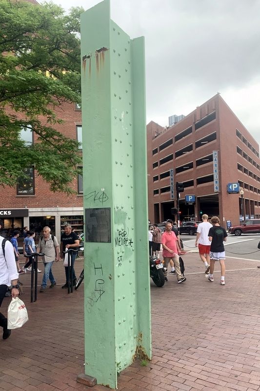
This structural column, known as "Bent 38", still rests on its original foundations and is the only piece of the elevated highway that was left undisturbed by construction. It remains as a memorial to the Expressway and to the impact that the health of our transportation systems have upon the life of the community. It also symbolizes the labor of scores of men and women who work to improve our infrastructure everyday.
Erected by Massachusetts Department of Transporation.
Topics. This historical marker is listed in this topic list: Roads & Vehicles. A significant historical year for this entry is 1951.
Location. 42° 21.641′ N, 71° 3.22′ W. Marker is in Boston, Massachusetts,
this page online

Regionally, this marker is in Massachusetts’ Historic Boston. It is also in the American Northeast, in New England, and on the Eastern Seaboard. Globally, it is in the North Atlantic Region, North America, the Western Hemisphere, the Western World, and the Anglosphere. Historically, it finds itself in what was once one of the original Thirteen Colonies.
Other nearby markers. At least 8 other markers are within walking distance of this marker: Armenian Genocide Memorial (within shouting distance of this marker); Larry "Legend" Bird (within shouting distance of this marker); Bill Rodgers (about 300 feet away, measured in a direct line); Arnold "Red" Auerbach (about 300 feet away); Spectacle Island (about 400 feet away); Boston Harbor Islands (about 400 feet away); Thompson Island (about 400 feet away); Peddocks Island
Photographed by Marc Posner, July 6, 2024
2. Bent 38
More about this marker. The "Green Monsters" mentioned on the marker are (1) the raised structures supporting the Expressway and its feeder roads as it passed through Boston and (2) the left field wall of Boston's Fenway Park.
Also see . . . Central Artery (Wikipedia). Boston's "Big Dig" (Submitted on July 31, 2024, by Michael Herrick of Southbury, Connecticut.)
Credits. This page was last revised on July 31, 2024. It was originally submitted on July 29, 2024, by Marc Posner of Somerville, Massachusetts. This page has been viewed 248 times since then and 29 times this year. Photos: 1, 2. submitted on July 29, 2024, by Marc Posner of Somerville, Massachusetts. • Michael Herrick was the editor who published this page.
